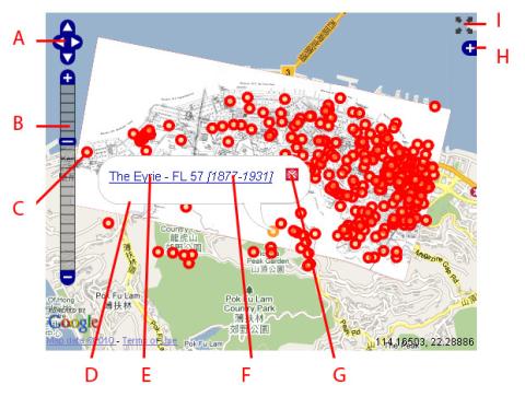
Here's a detailed, zoomable, scrollable, clickable map of Hong Kong from 1924, showing Central to Kennedy Town: (Show me) <= Click the 'Show me' to update the map above to show the 1924 overlay.
How to use the map
Pan: Use (A) to move around the map.
Zoom: Use (B) to zoom in and out. Try zooming in, as there's a lot more detail to see.
Markers: Each red marker (C) shows one Place that we've added. Typically that's a building, or other landmark.
Popups: If you click a marker, a popup window (D) appears. It shows the name of the place (E), and the years it was completed and demolished (F). The name is a link, you can click it to visit the Place and learn more about it, see photos, etc. When you've finished, click the red X (G) to close the popup.
Layers: Click the + (H) to see a short menu. There you can change the background, and hide / display the paper map or markers.
Fullscreen: Click this (I) to view a large, full-screen version of the map.
Alternatives: For experienced users you can also Pan using the arrow keys on your keyboard, or by dragging the map with your mouse. Zoom can also be controlled with the + / - keys on your keyboard, your mouse-wheel, or a double-click with your mouse.
More about this map
The map appeared in "Hong Kong, A Brief History and Guide of Hongkong and the New Territories", published by Kelly & Walsh, Ltd in 1924. There's a copy available in the local Royal Asiatic Society's library.
It appears that Kelly & Walsh licensed a copy of the map 'Plan of the City of Victoria", prepared in London by Stanfords (cf. an 1889 version of the same map shown in Plate 3-2, Mapping Hong Kong).
Lining it up with today's map was an interesting (ok, tedious) exercise. Most of the northern section lines up well, but the area south of Kennedy Road, east of Glenealy wasn't surveyed anywhere near as well. So, use that section of the map as a guideline only.
Still, it's a pleasure to see the map, and also how well the Place markers line up with the old map. You'll see the Western half of map isn't very well covered with markers. I hope this map will be a source of new Places for that part of Hong Kong.
If you have any questions, please leave a comment below.
Regards, David

Comments
Could you post the map in its
Could you post the map in its original form too ?
Map in its original form,
as requested: