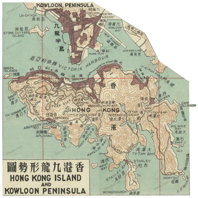
| NB: This is a hand-drawn commercial map and, as described below, its layout isn't always accurate. It is still a good source to see what was in Hong Kong in 1958, but don't rely on it to pinpoint the location of a building, street, etc. - please use one of the government maps for that instead. |
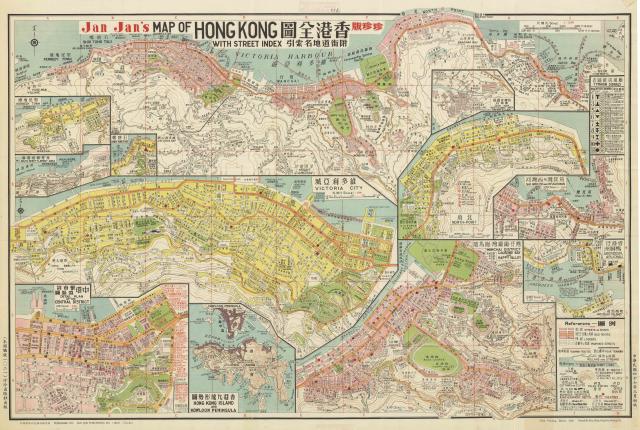
I've just finished adding this 1958 copy of Jan Jan's Map of Hong Kong to the maps on Gwulo. You can see it as an overlay by selecting the new '1958 HK' layer on any of Gwulo's maps, or go straight to it by clicking one of the links below:
- Kennedy Town, map only | Kennedy Town, map & markers
- Central, map only | Central, map & markers
- Causeway Bay, map only | Causeway Bay, map & markers
- North Point, map only | North Point, map & markers
- Shau Kei Wan, map only | Shau Kei Wan, map & markers
- Aberdeen, map only | Aberdeen, map & markers
Printed sheet map
Originally this was sold in Hong Kong as a printed sheet map. You may have seen it before, as the map is shown on Plate 7-3 of the excellent Mapping Hong Kong book, along with the note:
This is another remarkable private publication, and probably the first such street guide ever produced in Hong Kong. It obviously relies on government maps for basic data, a great deal of which has been crowded into the double-sided folded map. Though it may not be an example of good design, the map is certainly functional and is a fount of information. The reverse side contains the street index, a harbour plan, bus route information, and some imaginative ideas on alternative proposals for crossing the harbour — by tunnel, bridge, new ferry routes or by massive reclamation with roads and bridges to Kowloon via Stonecutters Island. At least two editions of this map have been identified and Jan Jan produced another version in 1961 entitled 'A Concise Map of Hong Kong and the New Territories' which showed Hong Kong Island on one side and the whole territory on the other.
Scanned copy
Back in November, Moddsey noted that the Australian National University (ANU) had a copy of 1958 Jan Jan's Map of Hong Kong Island 1:12 500 available for download. The ANU have done a great job of scanning the paper map, so the downloaded copies are sharp and high resolution.
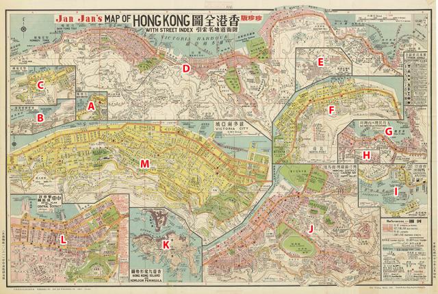
Here's a lower-resolution copy, which I've marked up to show the different sections.
Slice and dice
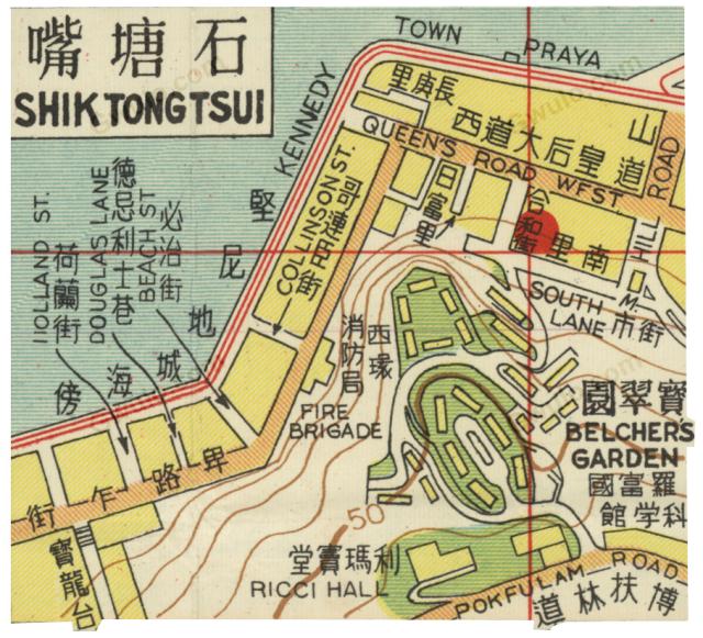
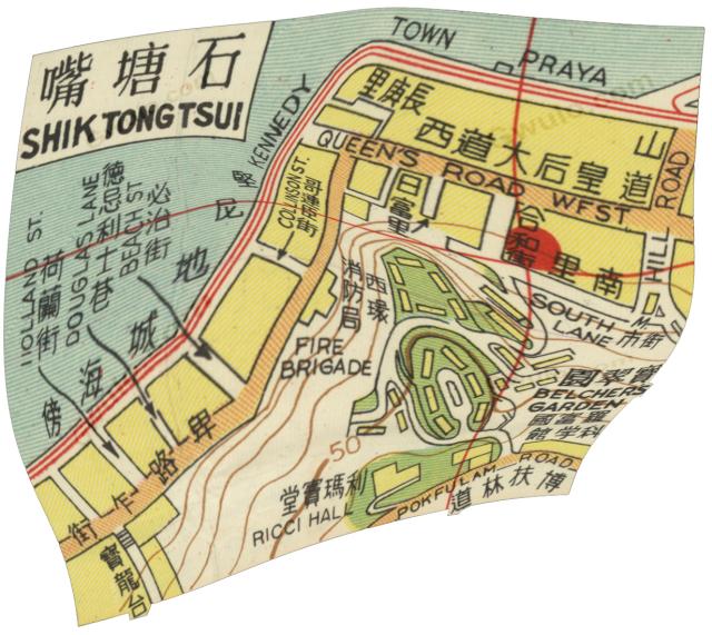
The first step towards adding the downloaded map to Gwulo is to open it in Photoshop, and cut it up into its different sections. Here's section A, showing Shek Tong Tsui (there are lots of spelling mistakes in the English captions on the map).
Georeference
The next job is to georeference each of the sections. Georeferencing a section adds information to its file that records which part of the world's surface it shows. The computer can use that information to display a section in the correct location on the modern maps.
I use the free, open-source QGIS tool for georeferencing. Here's what it looks like in use:
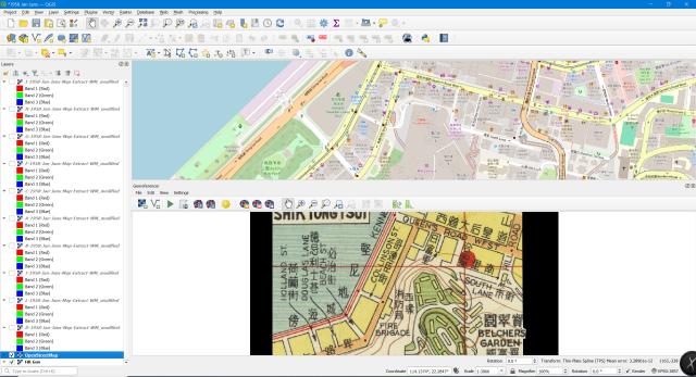
The georeferencing process is simple: I click a location on the scanned map, e.g. a road junction, and then I click the same location on the digital map above. If you zoom in to the above image you'll see red dots on the two maps, showing where I've clicked to add the connecting points.
If the scanned map is accurate this will be a quick job, needing as few as three points to finish aligning it.
But this is not an accurate map!
Problem 1: Jan Jan drew to fit the page, not the real world
Look at the blocks between the tram line on Kennedy Town Praya, and Belcher's Street. Collinson Street runs between them, and in the real world it is about half way between Queen's Road West at the top, and Sai Cheung Street at the bottom.
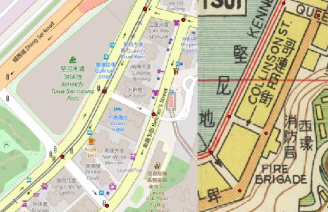
But 'Collinson Street' is a long name, so Jan Jan's artist moved the street down the map to make room for the name! Next look at how the Praya and Belcher's Street bend at the bottom. In the real world it is quite a gentle curve, but on Jan Jan's map there is a much sharper bend, drawn that way so that this section of the map takes up less room on the sheet.
It makes sense to the printer, and doesn't bother the average customer, but it is a pain for the georeferencer! This little section needed 14 points to force the scanned map to even roughly fit the real world. Here's what we end up with after georeferencing, showing how much it had to be warped and stretched to fit the shape of the real world.
Problem 2: just plain wrong!
There are also some parts of the map which can't be warped to fit the real world at all. Take Jan Jan's view of Johnston Road in Wanchai.
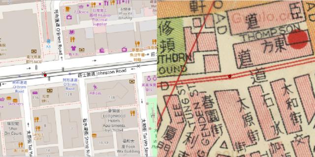
In the real world, O'Brien Road joins Johnston Road between the junctions with Tai Yuen Street and Stone Nullah Lane to the south. But in Jan Jan's world, O'Brien Road joins Johnston Road between the junctions with Spring Garden Lane and Tai Yuen Street.
I could either align the map based on the roads north of Johnston Road, which puts the roads south of Johnston Road in the wrong places, or I could make the southern roads right at the expense of the northern roads, but it is impossible to align the map so both are correct. If you look at the finished map on Gwulo, you'll see I chose a middle ground where neither the northern nor the southern roads look 100% right.
Reader beware!
Given those problems, there were several times I wondered whether it was better just to stop and discard this map, but then I'd see something interesting, e.g. that ...
- the rope factory in Kennedy Town was bigger than I'd imagined, and was still in operation in 1958, or
- a view of Ah King's slipways, clearly visible to the north of the recently reclaimed Victoria Park, or
- the names of all the major buildings in Central in 1958.
So as it can still be a useful tool to see what was in Hong Kong in 1958, and to get a rough idea of where a street or building was, I carried on. But remember: please take any locations of buildings or layouts of streets on Jan Jan's map with a large pinch of salt, and use one of the government maps for that information instead.
Final sections
There were two sections I didn't include. The first is section K, as although it shows all of Hong Kong Island and Kowloon, it doesn't have much detail:
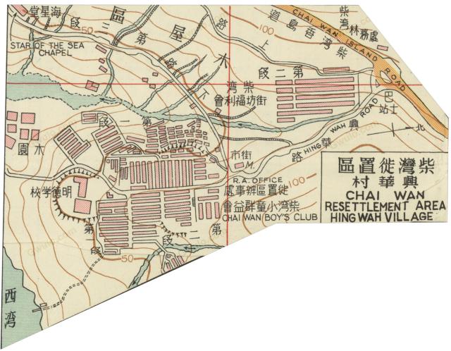
The other is section E, showing 'CHAI WAN RESETTLEMENT AREA, HING WAH VILLAGE'. We've got a Place on Gwulo for the Hing Wah Village, but I couldn't see how to align Jan Jan's map with the modern features. If you can work out jow it should be aligned, please let us know in the comments below.