The following post is courtesy of Rob Weir. He describes the pillboxes the British built around Hong Kong's coastline in the lead-up to the Japanese invasion. Over to Rob:
Pillboxes around the coast of Hong Kong island
Pillboxes (PB’s) were built on all beaches around HK Island considered suitable as landing sites for water borne attackers, as well as the waterfront areas along the northern coast in built-up areas [1].
[Each red marker shows one pillbox. Click any marker to see its name. Click the name for more details, and to see if we have any photos of that pillbox.
Subscribers - if you can't see the map, please click here to view the web version of this page.]
The map shows an obvious exception to the waterfront location: PB 45, built overlooking the valley behind Quarry Bay.
Originally, 72 pillboxes were planned, but as a result of exercises this was increased by at least a further six, and a photo exists of another one previously unknown [2].
Built to house the Vickers machine gun, they were considered bullet- and splinter-proof. Walls and roof were 12 inches (30.5 cm) thick, reinforced concrete. Each pillbox had between two and four firing loopholes, covered with outward-opening steel doors. Soldiers entered via an outward-opening, lockable steel door.
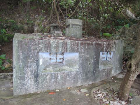
Pillbox 30 at Turtle Cove, viewed from the sea side. We can see two firing loopholes with their steel doors, and the round Commander's Turret on top.
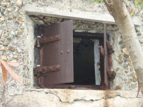
Close-up of a loophole and its outward-opening steel doors on Pillbox 29.
A Commander’s Turret protruded from the roof, accessed by a steel ladder inside the PB. This allowed him external visibility through an open slot, which could be closed by a sliding steel shutter. Ventilation within the PB was through a vertical airshaft on the outside rear wall and external airducts on the roof, to preformed holes through the roof. Construction of a two loophole PB was costed at £260.
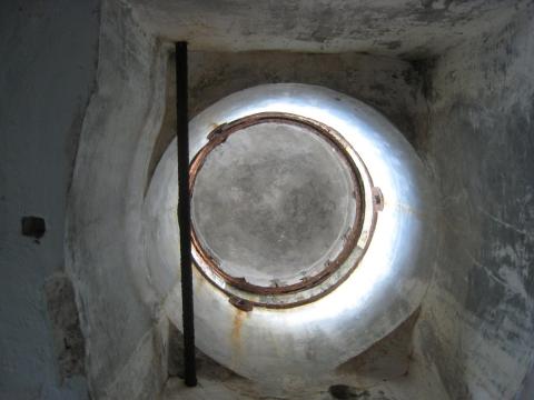
The view of the Commander's Turret of Pillbox 22 from below.
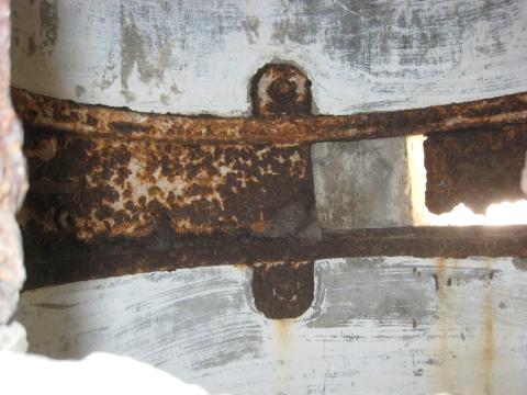
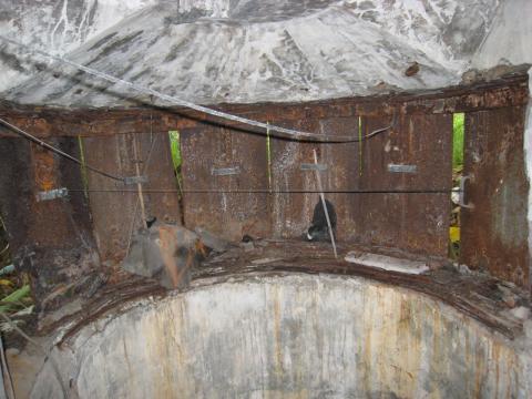
The remains of the sliding steel shutter in
the Commander's Turret of Pillbox 17.
A PB crew consisted of a commander and six men for a two-gun PB, increasing by two per additional gun fitted. Fold-away canvas stretchers were used during rest periods. Two of the PB crew were designated to operate the associated, adjacent, Lyon Light (LL). This was controlled by the PB Commander through voice via a speaking tube connecting the PB and LL, or predetemined whistle signals.
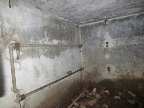
Remains of a couple of the fold-away stretchers on the walls of Pillbox 21.
Construction of these PB’s did not commence until after the revised Defence Plan of 1938 aimed to fully defend HK Island only. Initially, only those on the West, South and East coasts were constructed, due to difficulty in obtaining suitable land in the built-up area along the North coast.
As the probability of war increased in 1941, PB’s were built in the missing areas, but these were of a slightly different design, characterised by individual air vents on the roof, and vertical “steps” in the sides of the loopholes. These “steps” were a result of experience gained in the war in Europe, where it was found that smooth sided loopholes, as previously used in HK designs, deflected bullets and shrapnel into the loophole openings.
Attempts were made to camouflage the PB’s on beaches, using stones and rocks attached to the exterior faces, and at least one is known to have been painted to resemble adjacent beach huts. PB’s and LL’s were surrounded by fences and barbed wire entanglements.
PB crews were considered expendable. "INSTRUCTIONS FOR CLOSE DEFENCE OF BEACHES HONG KONG" states, in part:
There will be no withdrawing from M.G. Pillbox. By remaining in action even if completely surrounded a delay will be imposed on the enemy during which it may be possible to launch a counter attack and drive them back into the sea.
Lyon Lights
The Lyon Light was a small (20" diameter) carbon light projector (searchlight) used to illuminate the area of water in front of the defences. The light had a maximum range of 1,000 yards under favourable atmospheric conditions, reducing in poor conditions, for example, mist. It had its own self-contained generating set, powered by a Briggs and Stratton petrol engine, producing 12V power for the light.
The lights formed an important part of the beach defence. They generally had their own small concrete shelter, positioned to the side and behind the PB, so as not to blind the PB crew. A path connecting the two often had a protective wall on the sea side. (This can still be seen at PB/LL 30).
The shelter contained the light, mounted on a concrete shelf, behind steel shutters which opened out and down when the light was being used. The engine was mounted on other concrete shelves at the back, with holes through the wall for its air intake and exhaust, and there were two stretcher beds which folded up against the wall. An airshaft and duct on the roof formed a ventilation system through an outlet above the light. Construction cost of a concrete shelter was £60.
Lyon Light 16 can be seen on along the coastal path between
Deep Water Bay and Repulse Bay.
The view inside Lyon Light 4, showing the steel shutters that would fold out and down when the light was in use.
The LL was manned by two personnel from the PB crew. Communication between the PB and LL Shelter was by a speaking tube connecting the two. Colour coded arcs were painted around the shutter opening, corresponding with the same colours in front of the PB loopholes. This ensured that, through a series of whistle blasts initiated by the PB Commander, the light would be pointing in the same direction as the guns.
In some flat areas it was not possible to get the light to a higher position, other than by building the shelter on top of the Pillbox. There are several known positions where this was done, and probably others, but the only remaining example is PB 33a. Along the built-up area of Central, space precluded the construction of separate shelters, and lights were installed in adjacent buildings.
Several LL Shelters have been identified on post war aerial photographs on the mainland, but no sites or remains have been found. No written records appear to exist.
The lights were considered such an important part of beach defence at night that written instructions at the time bore the ominous note that, once the light had been exposed (illuminated), it should remain illuminated until the landing was defeated or the light was destroyed.
Beach Defence Units
The "Infantry Beach Defence Unit" was the official title of the combination of a Beach Pillbox, and its associated Lyon Light.
Depending on the length of the beach, there may be more than one unit (e.g. Repulse Bay beach had three, 17,18 and 19). Each unit was surrounded by barbed wire.
References:
- The reference for the PB positions is the HK Interim Defence Plan. A copy can be viewed at the UK National Archive, their reference WO 106/2379.
It was produced after the 1938 decision to attempt to defend only HK Island. It has some hand-written amendments dating up to Nov 1941, so presumably it was sort of current. It doesn't, however, have any details of Mainland defence using the extra forces created by the Canadians. - Pillbox 058a: http://gwulo.com/node/2110
Notes:
- Because the LL and PB were so close, in many cases the same coordinates have been used for both.
- This is best information available I have at present (2014). Further information or corrections will be appreciated.
Thanks to Rob for sharing the results of many hours of research and field trips. If you can add any photos or information about Hong Kong's pillboxes, please get in touch.
|
Elsewhere on Gwulo.com this week:
|
Comments
1940s Coastal Pillbox
1940s Coastal Pillbox. Location Unknown. More information on pillboxes can be viewed here
Philip has a good write-up
Philip's blog has a good write-up about the coastal pillboxes and their lyon lights. My favourite line is:
The PBs had stores of kettles, spades, maps, prismatic compasses, binoculars, sandbags and other equipment.
The British soldier was powered by tea, so it's good to see kettles listed!
Pathe Film of the Coastal Pillbox
1940 British Pathe Film of the Defence of Hong Kong. See here
PB & Minefield
Hi David,
I note your comment on the stores kept inside a PB. This newspaper clipping reveals that the stores were targeted by thieves, who in turn were targeted by soldiers - literally!
Hi Moddsey,
Thanks for the video link. I'm wondering if the footage at 0:31 - 0:33 shows PB and LL 14 at Deep Water Bay? The video is a bit blurred but I think it shows a LL shelter a short distance above, behind and to the left of the PB - same as at Deep Water Bay. Both the video and at PB 14 have a flat area infront of the PB with the land rising steeply to the rear and left. Most intriguingly, the video shows a dark, narrow, vertical slit on the left of the PB's front wall, which is very similar to the entrance to the narrow passage at PB 14 - a feature unique to PB 14 amongst the surviving PB's as far as I am aware.
On the negative side, the loops of the PB in the video appear to have small protruding frames above them, and the far end of the PB's front wall appears not to be flush with the remainder of the front wall, neither of which are present at PB 14 today.
The video footage at 0:41 - 0:44 is of the minefield and boom across the Tathong Channel with Cape Collinson Lighthouse on the left and Joss House Bay on the right.
Re: Coastal Pillbox
Hi gw, had the same thoughts about the location being Deep Water Bay. To film the pillbox, I would assume it would be a location that would be easily accessible. Thanks.
Thank you for the Gaumont
Thank you for the Gaumont British News footage of the pill box and Lyon Light shelter. On the whole I agree with gw and Moddsey about the likely location being PB14. However, I have two comments. The soldiers climbing from the pill box up to the Lyon Light shelter are going round to the left and not taking the flight of steps that appears on a slightly later image and was/still is immeditely on the left of the pill box. Another image on Gwulo clearly shows soldiers climbing those steps. This could easily be explained if the steps were built at a slightly later date to the shooting of the Pathe newsreel. My second thought is that at 37secs it would seem that there is no steep hillside behind the pillbox as shown on the earlier footage. My recollection and photographs taken in 2006 are also of a high, steep and rocky hillside - allbeit showing lots of landslip on and around the pill box.
I was interested to see the footage from 41sec showing the Cape Collinson lighthouse - an alnost identical view well remembered from my time in 1957/8.
However, the newsreel footage was almost certainly taken from the Cape Collinson Road a several hundred yards further to the East of its junction with the old Little Sai Wan camp road (Leaping Dragon Trail). Two things stem from that. If the camp road had been there in 1940, a closer and better view would have been had from the spot on that road where my photograph taken the 'cave' window overlooked the sea. So, in 1940 the camp road had not been built, and PB37 and its Lyon Light must have been serviced from the sea as I have recently speculated. Secondly I was intrigued to see that the Eastern boom defence was placed at such a wide part of the Eastern approaches. I had always thought that it must have been at the much narrower Lei Yue Mun, but this location ties in with the proxinity of the Cape Collinson battery.
I'll shortly add some photographs taken in 2006 into and around PB14 in my 2000 gallery. Cheers, Andrew
Coastal Pillbox
I hate fuzzy old pictures which promise so much, but only succeed in adding the identification difficulties. The video showing the beach PB looks similar to PB 14, but with enough differences to make me cautious about it, particularly the background and around the LL Shelter. The second I doubt is a PB as such, the loophole cover apparently opens downward onto the supports below, and this has not been seen on any other PB on the Island or Mainland. The PB that is firing is certainly not the first one shown - nor the second. The void shown on the right side of PB 14 is not unique, however its purpose is unknown. It goes along the side and back walls, but does not give access into the PB.
The film was obviously a PR exercise, whereby a number of troops were dragged around different places and told to do this or that, with the usual licences being taken. For example, why should a large number of troops, possibly six including one lugging a machine gun on his shoulder, be going to a LL Shelter whose crew was only two and had no room or mountings for a machine gun.
The pillbox in the video at
The pillbox in the video at 35s looks remarkably similar to the one at Pom fu Lam reservoir (but I'd
guess it's a pretty standard design)
B&wpillbox.png, by MalcolmM
Latest condition of Beach Defence Units from Tai Tam to Stanley
https://youtu.be/WyV2zmtITi8
This YouTube video shows the latest condition of PB030, PB029, PB027, LL024 and PB022. It's a pity that it only contains Cantonese narration and Chinese subtitles.
There're some more footages for Mount Davis and Jubilee Batteries in the same channel.
It's good for viewing if you're not going to visit them by yourself.
Pillbox Video Translation
Thank you Old Jim for the link to the video.
This is a Cantonese-to-English translation of the video - https://www.youtube.com/watch?v=WyV2zmtITi8 - about current condition of several Hong Kong’s war time pillboxes and Lyon search lights. This is not a professional translation, as its quality is limited to my knowledge of the spoken Cantonese words and ability to translate. Corrections are welcome.
I can only imagine the life of a soldier serving within and away from their home country. While standing, sitting or lying on the floor of these structures, many thoughts must have gone through their mind at moment of peace and battle - their hometown and family, friends and neighbours. As Remembrance Day approaches, may I salute them here, and watch this video to retrace their footsteps and see what they saw. OldTimer
0:04 One Person Walking.
0:13 Hi everyone, join us again for this happy countryside tour of Hong Kong’s war time coastal defence installations.
0:24 Previously, we had focused on Tai Tam and the sea, which led to three points of interest.
0:29 This is follow-up to previous discussion,
0:32 now from Tai Tam to Stanley,
0:33 we introduce five sites, some trips easy and some difficult.
0:36 Five sites in white, three others in red no longer exist, and PB025 is in restricted Stanley military area hence not accessible.
0:58 Let’s start the walk.
------------------------------------------------------------------------------------------------------
1:07 PB030 Turtle Cove (Beach)
1:09 To go to Turtle Cove, at Sai Wan take Bus #14.
1:18 Next walk down steps to the beach.
1:24 Follow the steps going down.
1:25 At bottom of stairs near beach, turn left.
1:30 Through rough vegetation growth and next we’ll see PB030 gun site.
1:38 Not much vegetation here, could be easy to find.
1:46 noted feature, at rear and up to the left is a path to search lights.
1:58 Let’s tour the pillbox.
2:02 Lookout at top of structure still there, some one had sealed off the opening.
2:07 The rear has become a garbage dump.
2:10 Let’s look at the front.
2:14 At front of two gun position, some metal parts still there.
2:25 Let’s go see inside.
2:26 This metal door is not the original.
2:30 Not locked, let’s go and see the inside.
2:35 The two gun supporting platform still here.
2:40 Looking up - Lookout tower (observation turret), opening blocked as mentioned earlier.
2:45 Interior quite clean and graffiti-free.
2:48 Someone installed iron bars at window.
2:52 Tour of this site ending, let’s see the search light site.
2:56 Behind the gun site, looks like a path going up.
3:01 The walk here not much better, up and down and miscellaneous stuff on ground.
3:09 End of this walk is search light site.
3:15 Not a lot of stuff here, few graffiti.
3:20 Gun window, looks like some hardware left there, left and right blinds at window.
3:40 Let’s again go look from the outside.
3:45 At top filled with vegetation hence not possible to see its exterior though standing next to it.
3:54 This site overlooking a sandy beach.
4:02 Tour of this site ends, let’s leave the place.
4:10 Turtle Cove Beach connects to Red Hill, these refer to as Red Hill Peninsula.
4:15 PB030 gun and search light sites were placed inside the bay, connected by a hidden path.
4:25 Both designed/located to repel invaders about to enter or already in the bay.
4:40 Search light site well hidden by thick vegetation by now, not visible from the air.
4:50 Short break.
[For more information about Pillbox 030, see: https://gwulo.com/node/1953]
-----------------------------------------------------------------------------------------------------------------
4:58 PB029 located near American Club, Country Club shore.
5:01 To American Club, also take Bus #14, get off next stop after Turtle Cove.
5:10 After getting off bus, walk in opposite direction and north (to Pacific View 38 Tai Tam Road), clockwise around building, then steps down to the beach.
5:20 Follow the concrete-lined water channel; and hop on the little bridge,
5:26 path to steps going up.
5:30 Beware of running into objects and wire barrier net to the side.
5:36 Next, along the walkway next to building until road ahead visible, turn left and go downhill.
5:42 Follow path leading to the abandoned house, go to the front of it and walk to the right.
5:57 Continue with retaining wall on your right.
6:05 This part of the land is rather hazardous perhaps.
6:08 Ground soil not firm, down leaves and miscellaneous,
6:12 and wet slippery rocks, easy to cause slippery fall.
6:18 Seeing two yellow tarps, you have arrived at LL029 search light structure.
6:28 Above here is the American Club private property,
6:32 so everyone be careful not to trespass.
6:34 Entrance has lots of rocky soil blocking it, so I am not entering it,
6:39 on the other hand, getting to the top is easy.
6:46 Airflow opening still there, but cover is gone.
6:52 Look to the left sea side, can see gun site.
7:04 From the top, take a look down at this place.
7:10 Most window mechanism gone.
7:14 Outside, some rocky soil and miscellaneous. Not much else.
7:26 To the left, there is a path to the gun place.
7:40 “PB029”
7:48 Much of this gun place still in good shape.
7:50 Here, many keys, their purpose?
8:00 This place has three shooting openings, hence three machine guns possible.
8:04 Inside, many graffiti.
8:07 Right gun aims to southeast,
8:12 the other two look to northeast Tortoise Cove Bay and its exterior.
8:30 Most openings remain open for air flow without obstruction.
8:37 Top observation tower’s (turret) cover and shutters gone.
8:47 Interior there are signs of alterations.
8:52 Ha! Another key.
8:58 Let’s go outside to take a look.
9:02 Opening for air flow (low left of picture) destroyed/damaged, so was the ladder to the roof.
9:09 So, going up to take a look.
9:12 On roof, two air flow passages, their cover and parts are missing.
9:17 Note these are air flow passages, not for diverting rain water or for light.
9:21 They too had exterior cover,
9:23 if not, rain will flood the interior turning it into a shower room.
9:27 Have we thought about the design of these air passage way?
9:30 why built at an angle on roof and not directly into the interior?
9:36 This design connects one air intake passage to another end called air intake site (not sure of the exact translation).
9:40 Also prevents invaders who climbs to the top to drop hand grenade, but (due to the design) can not fall into the interior and
9:45 turning occupants into Shake-Shake (Cantonese term for fried potatoes).
9:50 PB029 fire power cover a wide area from Stanley east bay to sea.
10:23 Its location serves also to cover PB030’s blind spot.
10:40 Search lights now hidden by vegetation,
10:46 difficult to spot it still there.
[For more information about PB029, see: https://gwulo.com/node/4663]
10:56 Short break.
------------------------------------------------------------------------------------------------------
11:06 “PB027 Stanley Bay east”
11:09 Stanley main beach, east, by water next to Stanley prison.
11:10 If you don’t want to go to prison, walk along water’s edge.
11:17 I start from the main beach, walk along water’s edge.
11:21 Part of the walk in water.
11:32 Take mini bus #16M, get off at Stanley main beach.
11:35 At beach, turn right and walk. Walk past a dock.
11:46 by now, here are rocks to walk on.
12:00 Arrow shows the spot where you must get into water.
12:07 I will change clothes and shoes and store them in water-proof bag.
12:10 Better wear proper wet suit and gloves.
12:12 because of rocks and many of them have sharp faces
12:15 that can cause injury.
12:18 Getting out of water, this is my carelessness. The thigh got it.
12:22 Around the rocks, coming upon a small beach.
12:25 Beyond this rock outcrop is PB027.
12:29 Straight to the far end of the beach on the right we will see the PB027 gun site.
12:34 On my return to Stanley main beach, I will shower and change clothing.
12:40 PB027 now only gun structure remaining, has been deteriorating and no longer in one piece.
12:50 Only base floor and partial wall visible.
12:54 Who forgot to collect their BBQ stove after they used it?
13:10 Designed for two guns.
13:20 Let’s go inside to take a look.
13:29 Except for this partial back wall remaining, other walls gone.
13:37 Guns aim at Hair Pin Beach (to the north).
13:42 Firepower extends to main beach and Red Hill.
13:59 Previous search could not find the site of its search light.
14:20 Like some relics, this will someday disappear.
14:35 PB027 located below Stanley prison by the beach,
14:40 normally difficult to access, one can walk from the main beach,
14:48 and part of the way in water.
14:50 So get your swim suits ready,
14:54 like water-proof bag, water-exercise shoes (right word?), and gloves to prevent cuts.
14:59 Also accessible by rowing boat.
15:02 Let’s imagine how the (original) pillbox looked like (artist impression)
[For more information about PB027, see: https://gwulo.com/node/19308]
15:25 Short break.
-------------------------------------------------------------------------------------------
15:35 “LL024 St. Stephen’s Bay/Beach”
15:38 Take Bus #14,
15:45 get off at St. Stephen’s Primary School - Wong Ma Kok
15:50 Cross the road and via Wong Ma Kok down to the beach.
15:58 At the beach, through parking and turn left,
16:00 Continue straight ahead.
16:15 At big building turn right towards the beach,
16:17 then turn left to continue.
16:20 Here, step over these big rocks to concrete ground.
16:33 Along and outside the chain-link fence.
16:40 Building inside is operated by some organization/association.
16:46 Reaching this point, one step up.
16:52 Until reaching the centre of the foothill on the left.
17:02 (Here, entrance to some sort of forest.)
17:05 Beware of steep grade, branches and wood,
17:09 soil not stable, not much to hold onto.
17:14 So, be extra careful while walking.
17:16 After passing two water tanks, we will reach LL024.
17:26 LL024, like PB024, is part of coastal defence
17:32 it is also surrounded by vegetation.
17:36 Access to top relatively easy.
17:42 From where I stand (I can see) air circulating system still there,
17:45 but top cover is missing.
17:50 Let’s look down from the pillbox top first.
17:56 Actually, I am standing on the part that was built/added at later date.
17:58 To the left are (unknown words).
18:10 After some effort, from there I go down to the entrance.
18:13 Interior has become a place for junks.
18:16 Original window openings altered to two small windows.
18:31 At entrance – extended overhead cover to make more space.
18:40 Original opening and added space.
18:44 From this angle, let’s look at the exterior,
18:47 unfortunately, too much vegetation is hiding the place.
18:57 Looking out of small window, view to outside is affected.
19:00 When entering and exiting, beware of overhead steel dangling.
19:04 PB024’s gun support mechanism certain had been removed/dismantled.
19:11 What remains now is search light shell a bit uphill.
19:16 From air, not possible to see it due to vegetation.
19:20 Good thing we found this place after researching about the building behind the chain-link fence,
19:26 their building in the centre and what’s behind it.
[For more information about PB024, see: https://gwulo.com/node/19305]
19:40 Short break.
-------------------------------------------------------------------------------------
19:53 “PB022 Stanley Bay”
19:56 For Stanley Bay, take mini Bus #16M at Chai Wan station,,
20:02 Exit at last stop, Chung Hom Kok Road.
20:04 To the left of bicycle parking, a lane to Stanley Ma Hang Park.
20:10 Not too far ahead, take the path branching off to the right.
20:17 After that, the path descends, just follow it.
20:26 After crossing the wood bridge, ladder-like path to the beach.
20:36 Beware of wild dogs.
20:44 Looks like the beach is now a boat repair place.
20:52 Coming to, and another walk by rocky place.
21:15 Ahead is PB022 gun position.
21:19 Walking here needs my both hands, hence no video recorded.
21:30 From rocky beach now up to the gun pillbox entrance.
21:33 Upon entry, notice place has changed to a mini storage place,
21:37 full of all kinds of fishing gears.
21:42 Top observation tower opening still there.
21:50 Window openings for two guns still there.
21:58 Interior looks like no alterations had occurred.
22:00 Much of interior is filled with miscellaneous stuff.
22:09 Believe space is used by local fishermen, a common place for all.
22:17 Front of structure not much room to move around.
22:20 On the other hand, at back, a lane to the rooftop.
22:32 Considering these guns, this pillbox covers the interior part of Stanley Bay.
22:54 Just noticing behind the pillbox is a lane way going uphill.
23:01 Oh, a flat spot here.
23:05 To the right, it looks like a private residence.
23:07 This flat spot looks like a small garden.
23:10 Let me walk to find the search light place,
23:14 but it looks like none exists.
23:18 What is left to do is to go down to the rocky beach to explore.
23:24 What a surprise, a face-like rock (up there).
23:27 Doesn’t it look like a Mohican head statue?
23:33 And it is next to PB022 (LL022).
23:40 To reach it, walk up from below.
23:45 “PB022 (LL022) “
23:50 Interior condition good, and quite clean.
23:54 front view to outside quite open/bright and no obstruction by vegetation.
23:58 But I ran into one thing after coming here.
24:01 Though sprayed myself with mosquito repellent, still got bitten by 10+mosquitoes or some crazy bugs.
24:06 Making me to not stay inside any longer, and get out asap.
24:11 A quick scan, no refuse or junks inside.
24:15 Outside, some re-bars exposed?
24:16 Top exterior air circulation still in good shape.
24:20 And some vegetation growth too.
24:23 Can’t cope with (mosquito?) situation, but
24:26 making me to suspect there is a path on the right side leading to somewhere.
24:30 Now leaving the place.
24:36 BP022 and search lights
24:43 located inside Stanley Bay, next to (several sites mentioned)
24:50 As mentioned earlier, place is clean and tidy.
24:55 Believe someone is looking after the place.
24:58 Compared with previous explorations,
25:00 this is not the first time seeing someone maintaining a place
25:02 and cleaning everywhere.
25:06 while it looks like someone is using the place,
25:09 the place is not being destroyed.
25:10 rather, it is getting cleaner.
25:13 by comparison, there has been more destruction of this kind of place.
25:19 Gun place though used as storage, it has not had much alteration.
25:25 When it is maintained by user(s), is it not a cultural protected place?
25:30 It appears this place is also accessible from Stanley’s Ma Hang Park.
[For more information about PB022, see: https://gwulo.com/node/53652]
25:47 Mission completed. (End of video)
Pillboxes at WNCG/Aberdeen Country Park
Sorry if I missed it, but were the above PBs part of the additional 6 PBs you refer to? So not in the original plan?
Pillbox Video Translation
Dear OldTimer,
I can't believe that you've done such a wonderful job. I'm indeed a Cantonese speaker so I understand the content of the video. (You can find out from my poor English expression.) I just feel sorry to have shared a link of video with no English subtitles here. (Supposed most of the members here can't understand Chinese.)
You're so kind to have translated the whole narration of the video. This can make those who can only read English enjoy the video.
You are a star!
Thanks a lot!
Old Jim
Pillbox Video Translation
Greetings,Old Jim, you are very welcome. Regards, Peter
re: Pillboxes at WNCG/Aberdeen Country Park
Yes, they weren't in the original batch of pillboxes. Rob talks about the later additions on this page: "Line of Gaps" pillboxes on Hongkong Island