I made a visit to the area recently and captured this image similar to the angle of your photograph. The original tower of the lighthouse is long gone. But I am curious about your remark of "man-made cave" under your original image caption. I am wondering if this could be the entrance of an ARP tunnel. The presnet-day map indicates that there is an ARP tunnel (Network 49) running from the Old Camp Road toward the seaside. I couldn't see any sign of it nowaday. Did you know about its location back in the old days?
Thanks for the current view. It confirms that we were both standing in the same place albeit 60 years apart! I hadn't heard that 'our' 1958 tunnel might have been an ARP tunnel, but I am not sure exactly what an ARP tunnel was for. What does Network 49 mean? Our tunnel was quite short, set back from and starting just above the road and was fairly narrow but just about high enough for me to stand up in. At the cliff edge it was wider and just before that I definitely recall that there was a steel girder across the roof which bore the name of Dorman and Long, a famous British steel firm. When I first re-found the exact spot in about 2001 the tunnel had been long demolished (probably in 1958 when several of the men from the construction gang arrived while we were in it. With hindsight, I suspect that they were already planning to demolish it on safety grounds. This demolition, whenever it was done clearly created the short cutting that now exists. The ARP tunnel shown on your 1949 plan looks longer than I remember, but it must be the same one.
At the top of your plan I think that the area enclosed in a wide line, is where the hillside was being excavated in 1958 to provide infill for our new sports field in front of the camp - see various photographs in my 1958 folder. In 1987, when I re-visited the area the excavation was already becoming very unstable and in, I think, 2002 it was being stabilised with lots of concrete. A friend told me recently that in 1958 he had explored a long and narrow tunnel that ran along the ridge above that excavation work and along towards the Point. He told me that it had side tunnels leading off it overlooking both the sea and our camp. He is convinced that this was a Japanese tunnel - they being very keen on digging tunnels, as we now know. In my 1958 colour photograph of Little Sai Wan, taken from the sea, you can see, with a bit of a stretch of imagination, what look like two or three dark features up there that could have been 'entrances' to that tunnel, just above the huge excavation work. Does your plan cover the area further North towards the Point, as we always called it?
I hope that all this helps to answer your question and clarify things a bit and does not cause confusion!
I really appreciate your prompt feedback and detailed description of the site and its surroundings. So now we are certain that the tunnel does exist but the entrances were most likely disappeared after the demolition you mentioned. I am quite sure that the tunnel you ran into with the steel girders was actually British and could also be used as air raid precaution tunnel (ARP) back then. The map with the indication of tunnel network is came from the slope safety map of civil engineering and development department (cedd). Only the dotted line area belongs to the tunnel. The path running due north with the solid outlines is actually Camp Road. Sorry there wasn't any tunnel heading to the Point to my knowledge. CEDD was so kind to label each ARP tunnel with its corresponding network number, and that's why it stirred up my interest when I first saw network no. 49 from the map. So you can tell it is a very short tunnel and might not open to civilians in wartime. Could that be an escape tunnel accessible mainly for the troops stationed there? As always, thank you for telling us the history and adventure around the area.
Thanks, Freddie
I think that the CEDD mapping probably took place after 1958 because the slope stabilisation programme was unlikely to be operating in what was a very remote part of the island and an area that was strictly off-limits to anyone other than the Service personnel stationed at R.A.F. Little SainWan. The short tunnel that is marked would possibly be marked because it was so close to the Camp road and quite visible from it. The long tunnel that my friend remembers was certainly above the large area of excavation and probably unknown to anyone other than my contemporaries on the camp who could roam more or less anywhere there - although some of us were wary of both the very fierce R.A.F. Police dogs that patrolled the hills and also the cobras and other snakes that were certainly very common in the grass and low vegetation. It is just, remotely possible that the long tunnel might still exist up there. I took a group of old men - like myself - back to Hong Kong for a week of nostalgia in December 2007 and I asked that friend if he could identify where 'his' tunnel had been but apart from saying that it was up above where the slope consolidation work had taken place a few years earlier, he and I hadn't the time, energy or motivation to climb up through the 'jungle' to look for it!
Yes, I realised that the path on the plan was the old camp road. Between 1987 and 2007 I walked up it every year when I returned to Hong Kong for my exploration of the old pill boxes and other military structures. That and sitting on 'our' sun-bathing rocks round the Point was my bit of personal nostalgia. I always had my swimming trunks with me but the water was not as clean as it had been in 1958, so I always delayed my nostalgic swims until I had walked up the camp road and over the hill to Big Wave Bay. Now the camp,road is a well-lit path used for exercise by so many of the thousands of people who live at Siu Sai Wan. I used to think that they must have thought it a bit odd seeing an old Gwuilo there sometimes talking into his camcorder as he trudged up the hill. Old Gwuilos should have been down in the city!! If they'd asked me, I'd have told them that I too had enjoyed living at Siu Sai Wan long before most of them were born.
No, I am pretty certain that the short tunnel 49 was never an escape tunnel. Escape on, I believe 18 or 19 December 1941, from the wireless station, pill box 37 and its associated Lyon Light installation was up towards Pottinger Peak and thence via the road across the TaiTam Tuk dam to Stanley. I don't think that the camp road was put in unti after the war and I have always thought that a natural escape route would have probably followed the catch waters that run round the flanks of Pottinger Peak and then used to lead down to the Tai Tam Tuk reservoir. In 1958 I once walked along a very big one up there. It's probably been filled in and is now the site of one of the huge cemeteries. The Lyon Light building still exists lower down on the ridge above the Point and has been well explored by several Gwulo members. It did cross my mind some years ago that the window sized opening at the end of the short tunnel could well have been an excellent observation post for observers looking out to watch for enemy shipping approaching the most important Eastern entrance to the harbour. That could have been manned by either the British or, after December 1941, the Japanese. British observation posts were usually substantial concrete structures as on the summit of Jardine's Lookout. The lookout at tunnel 49 was just hacked out of the loose and crumbling rock - like all the other Japanese tunnels I have seen.
My iPad battery is running very low so, that's all for now.
I've just downloaded the Geoinfo map (thanks for the link) and can confirm that N49/Network 49 is not the same as the cave/cutting discussed at www.gwulo.com/node/28598. The cave/cutting is not within the range of the small map Freedie posted above, but is visible on the full map on the website. The cave/cutting is just to the south of the area covered by Freddies map, on a single dotted line marking a path that runs roughly east/south-east from the road to the sea. The cave/cutting is not seperately labelled but the path runs through it right next to the road. The contours show that the cave/cutting runs across the lowest point of the ridge in this area.
That's very interesting. I have no recollection of another tunnel in the exact place where N 49 is marked and doubt whether there would have been 2 tunnels so close together. As the line of the old camp road is not, in my opinion, accurately marked - it was not as straight as that, I wonder whether N49 should have been marked as you and I agree the,current cutting is at the place where the camp road is closest to the low part of the ridge line..
Are you able to send me the link so that I can see the larger picture?
Re Andrew's request, I can't find a link on the map page and don't know how to copy contents. I'm basically useless if it involves computers. Would you mind doing the honours of posting a slightly larger version of the map you posted above please?
Thank you for the larger image. That is interesting. Tunnel 49 is clearly not the same one that I explored in1958. 'Mine' was almost certainly the one where the cutting and path down to the shore now exist. I suspect that tunnel 49 is possibly still there, slightly to the North of where the narrow cutting and path are. Andrew
SECOND THOUGHTS! I have a very strong feeling that before I got into the tunnel, I had to climb up a bit from the road to the tunnel's entrance and that the guys who were inspecting it all were on the road quite a bit below where I was at the tunnel entrance. So, that fits with the position of tunnel 49 on the map and not where the modern path in its cutting is. Looking at the map, I wonder whether I have been wrong all these years and that I actually did enter tunnel 49!! It was all a long time ago but the two photographs in my 1958 folder do seem to match very closely the ones that both I and several Gwulo members have taken in recent years at the place where the cutting overlooks the sea. All very confusing! Andrew
Thank you for taking the time to help identify the location of tunnel. Honestly, I am not quite familiar with the surroundings of this area apart from the AASL site up on the ridge. We did try to look for the entrance of N49 tunnel off the Camp Road last time without success. It seems to me that the entrance is situated high above the ground and blocked by heavy undergrowth. We didn't have time to check it out last time but will probably revisit the site sooner in future to verify. We did however go over to other side of the hill and tried to look for the eastward facing entrance. Unfortunately, we had no luck finding it except for a fallen signal mast. It is my first time to see its tip end up close and I don't know if all the signal masts were having the same design in this area.
Fallen Signal Mast, by Freddie
Fallen Signal Mast Cut in Half, by Freddie
We also discovered a pretty old pulley lying next to the mast. The company is Ansell Walsall and I don't know if it is still existed. But one thing for certain is that you can still find such vintage pulleys for sale in the internet nowadays.
Vintage Ansell Walsall 6 Inch 3 Rope Pulley - Front, by Freddie
Vintage Ansell Walsall 6 Inch 3 Rope Pulley, by Freddie
The terrain on the eastside of the hill is very steep and tough to natvigate. So I don't know why they would pick such location to become the exit of the tunnel. So my only hope is to find out the entrance of the Camp Road and see if it can lead us to the other entrance.
Here is another picture of the base structure of the signal mast with the ground wire that I found around the area.
If you zoom in on one or two of my 1957/8 photographs taken from the Cape Collinson road younwill see that there were several very big four legged aerial masts down near the sea but a lot more quite simple masts dotted around the hillside above the camp. The four legged ones were probably demolished after the camp closed but some of the single column ones like the one on your photographs were left standing as not being worth salvaging and, in the years when I returned between 1987 and 2007 a few of them were still visible standing not far below the camp road, protruding up out of the dense vegetation, but gradually being covered in climbing plants, so they might now be completely hidden in the tall vegetation. When I was trying to get to the AASL building in the early 2000s I followed a rough path down the ridge and came to a clearing which had obviously been the site of one of those masts. There, I took a photograph of a piece of concrete that had benn used to anchor a mast stay and whoever had made it had scratched 1961 or maybe 1962 into the wet concrete. From there I followed an even narrower and very rough path that led me down to the gate at the lighthouse.
I'm still wondering just were 'my' tunnel was. The two photographs that I took in 1958 do seem to point to it being where the narrow cutting is but it was longer than that cutting so either there has been a lot of cliff erosion there in the past 60 years or, more likely it might still exist in the spot marked on the map. I have just realised that a late friend who was at Little Sai Wan about two years after me took two photographs in the tunnel so my earlier speculation that the workmen were thinking of demolishing the tunnel on safety grounds cannot have been correct. I'll try to find those photographs and add them to my 1957-8 folder.
Your pulley looks to be in remarkably good shape considering it had probably been exposed to the weather for many years. It was probably manufactured by the company that is today called "Ansell Jones", based in Darlaston which is near or a suburb of the town of Wallsall in the English West Midlands. Their website (www.anselljones.com) says they were founded in 1845 and claims that they are "world leaders in high quality lifting and mooring equipment". It doesn't say if the "Jones" part of the name has been used from the start.
Why don't you send them your photos of the pulley to see if they can suggest a year of manufacture?
That is a very interesting video on Youtube so many thanks for drawing my attention to it. Unfortunately I do not speak Cantonese so was not able to follow the dialogue.
However, I see that the video starts at the short cave (now cutting) at the point where the road is closest to the top of the ridge line. That fits exactly with my own an other photographs taken in 1957/8, and at least one that was taken in the early 2000s when I was able to revisit the spot.
More interesting is that an old colleague of mine from the 1957/8 period told me years ago that he had then explored a very long tunnel that basically contoured along the ridge somewhere above the road and that it had several short tunnels heading off to overlook the sea. He says that he even escorted other friends along them all - a pity I missed out on that! That would fit very well with what the video now shows, but I have a feeling that tunnel 49 is further down the camp road from 'my' tunnel and that would fit with a very simple sketch that my friend gave me in 2006. He was in the group that I took back on our nostalgic trip in late 2007 and he and I stood some along the road and decided that his long tunnel was somewhere above where the now large concreted slope is (probably hidden from view by thick vegetation) next to the road. Perhaps someone who can translate relevant parts of the video commentary might be able to confirm the location of tunnel 49.
Later on in the video I am fairly certain that it covers the very steep drop down the cliff to the small bay close to where there was an observation post much nearer to the old Camp Collinson and battery - now the Correctional Institute.
So the first tunnel is located a hundred metres down the road from the short tunnel/ cutting, and the second tunnel is located on the ridge next to the start of the camp road, facing the Pottinger Peak and Cape Collinson Road.
From the look of the tunnels, I think the first tunnel was very likely an observation post, since it commands a clear view of the bay. It could also be a headquarters or an underground supply depot, as the entrance section of the tunnel is quite large. The second tunnel looks like it could have had a small artillery gun mounted in it's "main" entrance, and other entrances were probably used as machine gun posts or access points.
Thank you for clarifying things. 'My' very short tunnel/now a cutting at the place where the road is closest to the ridge line was always thought of as being an observation post - I recall that its 'window' seemed very wide, providing an excellent view over the sea but the cave didn't seem large enough to hold a gun.
I am really intrigued by your suggestion that the long tunnel is right up at the top of the camp road, close to the first sharp bend in the road - or am I mistaken. My friend's memory was that 'his' long tunnel was much further down the camp road somewhere above the area where the contractors were removing a huge area of material from the ridge to infill the sea for the new sports field and approximately below where the 'pimple' cairn is at the highest part of the ridge. Are we at cross purposes?
I believe that the tunnel your friend mentioned might be the large tunnel system shown in the video ( 11:25 - 17:00). The tunnel shares many characteristics with the description of the tunnel which your friend visited. Your friend might have accessed the tunnel from the area where there is a recently concreted slope. There is a trail running north to south on the ridge that more or less leads to the tunnel, and he might have ended up on that trail after climbing up from the road. Either this theory is correct, or there is still another unexplored tunnel.
Another strange thing about " Tunnel 49" in the video is that the section leading to the "observation window", and the large section of the cave is connected by a vertical shaft, in which you will have to climb up to reach the "observation window". This doesn't make any sense, as it is extremely strange to dig vertically up, as you could just have dug vertically, since both points have a clear view of the bay. Maybe they dug the "observation window" and the main section of the cave seperately and just connected them over time.
To reiterate my earlier comment, I believe that "Tunnel 49" and your short tunnel/cutting, were both used as observation posts. Having two observation posts quite close together means that there should have been a sizable artillery position nearby. I feel like it either means that the large tunnel system was used as a artillery gun position, or it might have been used to coordinate artillery fire from the Collinson Battery, which was probably occupied and put in use by the Japanese.
I think that what you suggest in all three paragraphs is very likely. I only walked along part of that trail along the ridge once, probably in 2004 when I unsuccessfully tried to find the Lyon Light shelter building up there. Being very much aware that nobody had the faintest idea where I was and not having a mobile phone in those days I tended to stick to paths, so I missed out on locating quite a few places that have become readily(?) accessible now.
As far as I know there were no Japanese guns of any calibre in that area but observation posts must have been quite prevalent and that ridge would be a perfect location for them - but why there was such a complex tunnel system is a bit of a mystery. As I discovered from the 1945 aerial photographs the Japanese certainly took over the British wireless station. A photograph taken in 1953 by one of the 367 members (rather blurred so I didn't upload it) shows one of the two tall wireless masts, just visible on the 1945 aerial photograph, in the process of being demolished, and there is evidence on the aerial photograph of several small buildings (huts?) towards the bottom of the camp road. I think that the Japanese must have had a reasonably strong presence down there - both for wireless and observational reasons. I'll try to enhance that photograph by Don Thrower and upload it into his gallery and then add it here. Success - and I'll now try to insert the annotated RAF aerial photograph taken in 1945. Andrew
little Sai Wan wartime aerial mast 1953, by Andrew Suddaby
I just thought of another possibility. What if the observation posts and the large tunnel system were used as anti-commando defences. If the Japanese had a wireless station there, they would have had to establish defensive measures against any commando raids by the Allies. Constructing tunnels that overlook the approaches to Ngan Wan ( the Cantonese name for Cape Collinson Bay), would be necessary in order to halt a commando raid.
Another theory is that the large tunnel system was used to house an AA gun. If an AA gun was stationed there, it would cover the skies above the Little Sai Wan Bay, necessary to defend the wireless station from American bombing raids.
The hut in the foreground of the 1953 picture definitely looks Japanese in design. I also wonder if the Japanese also built those aerial masts, as I feel like the original British aerial masts would have been destroyed or heavily damaged when the Japanese shelled the area during the Battle of Hong Kong.
I don't think that there is any evidence to suggest that the Japanese tunnels at Siu Sai Wan were intended as a precaution against possible Allied attacks on their wireless station, which was probably not their main one, or that the tunnels contained any anti aircraft guns. Perhaps Rob Weir might have some thoughts on both issues.
I too had noticed that the small building in the foreground of Don's photograph looks like a Japanese one, but as the 1945 aerial photograph is rather indistinct in that area I didn't annotate it. It was certainly not British and it must have been demolished very soon after Don took his photograph in order to make way for the 367 unit's car park / small parade ground.
Interesting to see your new post. The dashed line looks familiar to me. I recall that in 2005(?) when trying to get to the Lyon Light shelter I climbed the steps at the left hand side of the huge concreted area and turned left. I decided not to fight my way through the very dense vegetation to the shelter that I could just see down towards the Point, and followed quite a broad path down the ridge and came to a small clearing. This was very likely the site of a post war aerial mast - a very small cable anchoring block dated 1962(?) suggested what had been there. I then took a very narrow and partly overgrown path down to the lighthouse.
The only other Japanese military installation that I know about is the Japanese observation station on Violet Hill. A few months ago, I bushwhacked all over the eastern slopes of Violet Hill, and discovered what appeared to be Japanese tunnels, foxholes and most mysteriously, there were stone walls and platforms. I feel like there are always some strange stone ruins near Japanese military installations, such as the strange stone building on pottinger peak, which might have been a water collection point for the Japanese in Little Sai Wan.
There was a stone obelisk on the summit of Violet Hill that was built by the Japanese to mark their installation. Would there have been a similar one in Little Sai Wan?
Comments
Same View Today
Here's the view today.
See comments at www.gwulo.com/media/22207.
Very good. Thank you for both
Very good. Thank you for taking both the up to date photographs. Andrew
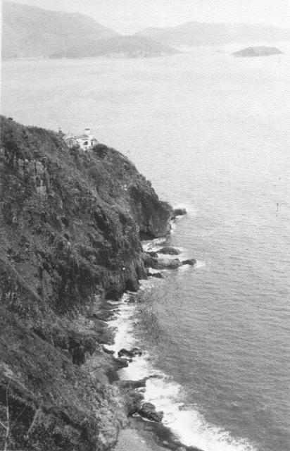
Cape Collinson Lighthouse and ARP tunnel
Hi Andrew,
I made a visit to the area recently and captured this image similar to the angle of your photograph. The original tower of the lighthouse is long gone. But I am curious about your remark of "man-made cave" under your original image caption. I am wondering if this could be the entrance of an ARP tunnel. The presnet-day map indicates that there is an ARP tunnel (Network 49) running from the Old Camp Road toward the seaside. I couldn't see any sign of it nowaday. Did you know about its location back in the old days?
Regards,
Freddie
Lighthouse ex cave window
Hi Freddie
Thanks for the current view. It confirms that we were both standing in the same place albeit 60 years apart! I hadn't heard that 'our' 1958 tunnel might have been an ARP tunnel, but I am not sure exactly what an ARP tunnel was for. What does Network 49 mean? Our tunnel was quite short, set back from and starting just above the road and was fairly narrow but just about high enough for me to stand up in. At the cliff edge it was wider and just before that I definitely recall that there was a steel girder across the roof which bore the name of Dorman and Long, a famous British steel firm. When I first re-found the exact spot in about 2001 the tunnel had been long demolished (probably in 1958 when several of the men from the construction gang arrived while we were in it. With hindsight, I suspect that they were already planning to demolish it on safety grounds. This demolition, whenever it was done clearly created the short cutting that now exists. The ARP tunnel shown on your 1949 plan looks longer than I remember, but it must be the same one.
At the top of your plan I think that the area enclosed in a wide line, is where the hillside was being excavated in 1958 to provide infill for our new sports field in front of the camp - see various photographs in my 1958 folder. In 1987, when I re-visited the area the excavation was already becoming very unstable and in, I think, 2002 it was being stabilised with lots of concrete. A friend told me recently that in 1958 he had explored a long and narrow tunnel that ran along the ridge above that excavation work and along towards the Point. He told me that it had side tunnels leading off it overlooking both the sea and our camp. He is convinced that this was a Japanese tunnel - they being very keen on digging tunnels, as we now know. In my 1958 colour photograph of Little Sai Wan, taken from the sea, you can see, with a bit of a stretch of imagination, what look like two or three dark features up there that could have been 'entrances' to that tunnel, just above the huge excavation work. Does your plan cover the area further North towards the Point, as we always called it?
I hope that all this helps to answer your question and clarify things a bit and does not cause confusion!
best wishes, Andrew
Air Raid Precaution Tunnel
Hi Andrew,
I really appreciate your prompt feedback and detailed description of the site and its surroundings. So now we are certain that the tunnel does exist but the entrances were most likely disappeared after the demolition you mentioned. I am quite sure that the tunnel you ran into with the steel girders was actually British and could also be used as air raid precaution tunnel (ARP) back then. The map with the indication of tunnel network is came from the slope safety map of civil engineering and development department (cedd). Only the dotted line area belongs to the tunnel. The path running due north with the solid outlines is actually Camp Road. Sorry there wasn't any tunnel heading to the Point to my knowledge. CEDD was so kind to label each ARP tunnel with its corresponding network number, and that's why it stirred up my interest when I first saw network no. 49 from the map. So you can tell it is a very short tunnel and might not open to civilians in wartime. Could that be an escape tunnel accessible mainly for the troops stationed there? As always, thank you for telling us the history and adventure around the area.
Thanks, Freddie
Hello Freddie,
Hello Freddie,
I think that the CEDD mapping probably took place after 1958 because the slope stabilisation programme was unlikely to be operating in what was a very remote part of the island and an area that was strictly off-limits to anyone other than the Service personnel stationed at R.A.F. Little SainWan. The short tunnel that is marked would possibly be marked because it was so close to the Camp road and quite visible from it. The long tunnel that my friend remembers was certainly above the large area of excavation and probably unknown to anyone other than my contemporaries on the camp who could roam more or less anywhere there - although some of us were wary of both the very fierce R.A.F. Police dogs that patrolled the hills and also the cobras and other snakes that were certainly very common in the grass and low vegetation. It is just, remotely possible that the long tunnel might still exist up there. I took a group of old men - like myself - back to Hong Kong for a week of nostalgia in December 2007 and I asked that friend if he could identify where 'his' tunnel had been but apart from saying that it was up above where the slope consolidation work had taken place a few years earlier, he and I hadn't the time, energy or motivation to climb up through the 'jungle' to look for it!
Yes, I realised that the path on the plan was the old camp road. Between 1987 and 2007 I walked up it every year when I returned to Hong Kong for my exploration of the old pill boxes and other military structures. That and sitting on 'our' sun-bathing rocks round the Point was my bit of personal nostalgia. I always had my swimming trunks with me but the water was not as clean as it had been in 1958, so I always delayed my nostalgic swims until I had walked up the camp road and over the hill to Big Wave Bay. Now the camp,road is a well-lit path used for exercise by so many of the thousands of people who live at Siu Sai Wan. I used to think that they must have thought it a bit odd seeing an old Gwuilo there sometimes talking into his camcorder as he trudged up the hill. Old Gwuilos should have been down in the city!! If they'd asked me, I'd have told them that I too had enjoyed living at Siu Sai Wan long before most of them were born.
No, I am pretty certain that the short tunnel 49 was never an escape tunnel. Escape on, I believe 18 or 19 December 1941, from the wireless station, pill box 37 and its associated Lyon Light installation was up towards Pottinger Peak and thence via the road across the TaiTam Tuk dam to Stanley. I don't think that the camp road was put in unti after the war and I have always thought that a natural escape route would have probably followed the catch waters that run round the flanks of Pottinger Peak and then used to lead down to the Tai Tam Tuk reservoir. In 1958 I once walked along a very big one up there. It's probably been filled in and is now the site of one of the huge cemeteries. The Lyon Light building still exists lower down on the ridge above the Point and has been well explored by several Gwulo members. It did cross my mind some years ago that the window sized opening at the end of the short tunnel could well have been an excellent observation post for observers looking out to watch for enemy shipping approaching the most important Eastern entrance to the harbour. That could have been manned by either the British or, after December 1941, the Japanese. British observation posts were usually substantial concrete structures as on the summit of Jardine's Lookout. The lookout at tunnel 49 was just hacked out of the loose and crumbling rock - like all the other Japanese tunnels I have seen.
My iPad battery is running very low so, that's all for now.
best wishes, Andrew
N49 and the Cave/Cutting
Hi Andrew & Freddie,
I've just downloaded the Geoinfo map (thanks for the link) and can confirm that N49/Network 49 is not the same as the cave/cutting discussed at www.gwulo.com/node/28598. The cave/cutting is not within the range of the small map Freedie posted above, but is visible on the full map on the website. The cave/cutting is just to the south of the area covered by Freddies map, on a single dotted line marking a path that runs roughly east/south-east from the road to the sea. The cave/cutting is not seperately labelled but the path runs through it right next to the road. The contours show that the cave/cutting runs across the lowest point of the ridge in this area.
Hi,
Hi,
That's very interesting. I have no recollection of another tunnel in the exact place where N 49 is marked and doubt whether there would have been 2 tunnels so close together. As the line of the old camp road is not, in my opinion, accurately marked - it was not as straight as that, I wonder whether N49 should have been marked as you and I agree the,current cutting is at the place where the camp road is closest to the low part of the ridge line..
Are you able to send me the link so that I can see the larger picture?
best wishes, Andrew
N49 and the Cave/Cutting
Hi Freddie,
Re Andrew's request, I can't find a link on the map page and don't know how to copy contents. I'm basically useless if it involves computers. Would you mind doing the honours of posting a slightly larger version of the map you posted above please?
Thanks GW
Here's the map of that area
Cave Window
Thank you for the larger image. That is interesting. Tunnel 49 is clearly not the same one that I explored in1958. 'Mine' was almost certainly the one where the cutting and path down to the shore now exist. I suspect that tunnel 49 is possibly still there, slightly to the North of where the narrow cutting and path are. Andrew
SECOND THOUGHTS! I have a very strong feeling that before I got into the tunnel, I had to climb up a bit from the road to the tunnel's entrance and that the guys who were inspecting it all were on the road quite a bit below where I was at the tunnel entrance. So, that fits with the position of tunnel 49 on the map and not where the modern path in its cutting is. Looking at the map, I wonder whether I have been wrong all these years and that I actually did enter tunnel 49!! It was all a long time ago but the two photographs in my 1958 folder do seem to match very closely the ones that both I and several Gwulo members have taken in recent years at the place where the cutting overlooks the sea. All very confusing! Andrew
N49 Tunnel & Signal Mast
Hi Andrew, David & gw,
Thank you for taking the time to help identify the location of tunnel. Honestly, I am not quite familiar with the surroundings of this area apart from the AASL site up on the ridge. We did try to look for the entrance of N49 tunnel off the Camp Road last time without success. It seems to me that the entrance is situated high above the ground and blocked by heavy undergrowth. We didn't have time to check it out last time but will probably revisit the site sooner in future to verify. We did however go over to other side of the hill and tried to look for the eastward facing entrance. Unfortunately, we had no luck finding it except for a fallen signal mast. It is my first time to see its tip end up close and I don't know if all the signal masts were having the same design in this area.
We also discovered a pretty old pulley lying next to the mast. The company is Ansell Walsall and I don't know if it is still existed. But one thing for certain is that you can still find such vintage pulleys for sale in the internet nowadays.
The terrain on the eastside of the hill is very steep and tough to natvigate. So I don't know why they would pick such location to become the exit of the tunnel. So my only hope is to find out the entrance of the Camp Road and see if it can lead us to the other entrance.
Here is another picture of the base structure of the signal mast with the ground wire that I found around the area.
Regards,
Freddie
Hi Freddie,
Hi Freddie,
If you zoom in on one or two of my 1957/8 photographs taken from the Cape Collinson road younwill see that there were several very big four legged aerial masts down near the sea but a lot more quite simple masts dotted around the hillside above the camp. The four legged ones were probably demolished after the camp closed but some of the single column ones like the one on your photographs were left standing as not being worth salvaging and, in the years when I returned between 1987 and 2007 a few of them were still visible standing not far below the camp road, protruding up out of the dense vegetation, but gradually being covered in climbing plants, so they might now be completely hidden in the tall vegetation. When I was trying to get to the AASL building in the early 2000s I followed a rough path down the ridge and came to a clearing which had obviously been the site of one of those masts. There, I took a photograph of a piece of concrete that had benn used to anchor a mast stay and whoever had made it had scratched 1961 or maybe 1962 into the wet concrete. From there I followed an even narrower and very rough path that led me down to the gate at the lighthouse.
I'm still wondering just were 'my' tunnel was. The two photographs that I took in 1958 do seem to point to it being where the narrow cutting is but it was longer than that cutting so either there has been a lot of cliff erosion there in the past 60 years or, more likely it might still exist in the spot marked on the map. I have just realised that a late friend who was at Little Sai Wan about two years after me took two photographs in the tunnel so my earlier speculation that the workmen were thinking of demolishing the tunnel on safety grounds cannot have been correct. I'll try to find those photographs and add them to my 1957-8 folder.
Keep exploring and best wishes, Andrew
Your Pulley
Hi Freddie,
Your pulley looks to be in remarkably good shape considering it had probably been exposed to the weather for many years. It was probably manufactured by the company that is today called "Ansell Jones", based in Darlaston which is near or a suburb of the town of Wallsall in the English West Midlands. Their website (www.anselljones.com) says they were founded in 1845 and claims that they are "world leaders in high quality lifting and mooring equipment". It doesn't say if the "Jones" part of the name has been used from the start.
Why don't you send them your photos of the pulley to see if they can suggest a year of manufacture?
Your tunnel still exists
Hi guys
This tunnel ( tunnel 49) still exists, and there is a recent video on Youtube of people exploring it.
Link to video: https://www.youtube.com/watch?v=1ChPSxQojH0&t=502s
Tunnel 49
Thank you Lewis,
That is a very interesting video on Youtube so many thanks for drawing my attention to it. Unfortunately I do not speak Cantonese so was not able to follow the dialogue.
However, I see that the video starts at the short cave (now cutting) at the point where the road is closest to the top of the ridge line. That fits exactly with my own an other photographs taken in 1957/8, and at least one that was taken in the early 2000s when I was able to revisit the spot.
More interesting is that an old colleague of mine from the 1957/8 period told me years ago that he had then explored a very long tunnel that basically contoured along the ridge somewhere above the road and that it had several short tunnels heading off to overlook the sea. He says that he even escorted other friends along them all - a pity I missed out on that! That would fit very well with what the video now shows, but I have a feeling that tunnel 49 is further down the camp road from 'my' tunnel and that would fit with a very simple sketch that my friend gave me in 2006. He was in the group that I took back on our nostalgic trip in late 2007 and he and I stood some along the road and decided that his long tunnel was somewhere above where the now large concreted slope is (probably hidden from view by thick vegetation) next to the road. Perhaps someone who can translate relevant parts of the video commentary might be able to confirm the location of tunnel 49.
Later on in the video I am fairly certain that it covers the very steep drop down the cliff to the small bay close to where there was an observation post much nearer to the old Camp Collinson and battery - now the Correctional Institute.
Regards Andrew
Tunnel locations
Hi Andrew
So the first tunnel is located a hundred metres down the road from the short tunnel/ cutting, and the second tunnel is located on the ridge next to the start of the camp road, facing the Pottinger Peak and Cape Collinson Road.
From the look of the tunnels, I think the first tunnel was very likely an observation post, since it commands a clear view of the bay. It could also be a headquarters or an underground supply depot, as the entrance section of the tunnel is quite large. The second tunnel looks like it could have had a small artillery gun mounted in it's "main" entrance, and other entrances were probably used as machine gun posts or access points.
Lewis
Hi Lewis, Thank you for…
Hi Lewis,
Thank you for clarifying things. 'My' very short tunnel/now a cutting at the place where the road is closest to the ridge line was always thought of as being an observation post - I recall that its 'window' seemed very wide, providing an excellent view over the sea but the cave didn't seem large enough to hold a gun.
I am really intrigued by your suggestion that the long tunnel is right up at the top of the camp road, close to the first sharp bend in the road - or am I mistaken. My friend's memory was that 'his' long tunnel was much further down the camp road somewhere above the area where the contractors were removing a huge area of material from the ridge to infill the sea for the new sports field and approximately below where the 'pimple' cairn is at the highest part of the ridge. Are we at cross purposes?
Andrew
Confused
Hi Andrew
I believe that the tunnel your friend mentioned might be the large tunnel system shown in the video ( 11:25 - 17:00). The tunnel shares many characteristics with the description of the tunnel which your friend visited. Your friend might have accessed the tunnel from the area where there is a recently concreted slope. There is a trail running north to south on the ridge that more or less leads to the tunnel, and he might have ended up on that trail after climbing up from the road. Either this theory is correct, or there is still another unexplored tunnel.
Another strange thing about " Tunnel 49" in the video is that the section leading to the "observation window", and the large section of the cave is connected by a vertical shaft, in which you will have to climb up to reach the "observation window". This doesn't make any sense, as it is extremely strange to dig vertically up, as you could just have dug vertically, since both points have a clear view of the bay. Maybe they dug the "observation window" and the main section of the cave seperately and just connected them over time.
To reiterate my earlier comment, I believe that "Tunnel 49" and your short tunnel/cutting, were both used as observation posts. Having two observation posts quite close together means that there should have been a sizable artillery position nearby. I feel like it either means that the large tunnel system was used as a artillery gun position, or it might have been used to coordinate artillery fire from the Collinson Battery, which was probably occupied and put in use by the Japanese.
Lewis
Hi LewisI think that what…
Hi Lewis
I think that what you suggest in all three paragraphs is very likely. I only walked along part of that trail along the ridge once, probably in 2004 when I unsuccessfully tried to find the Lyon Light shelter building up there. Being very much aware that nobody had the faintest idea where I was and not having a mobile phone in those days I tended to stick to paths, so I missed out on locating quite a few places that have become readily(?) accessible now.
As far as I know there were no Japanese guns of any calibre in that area but observation posts must have been quite prevalent and that ridge would be a perfect location for them - but why there was such a complex tunnel system is a bit of a mystery. As I discovered from the 1945 aerial photographs the Japanese certainly took over the British wireless station. A photograph taken in 1953 by one of the 367 members (rather blurred so I didn't upload it) shows one of the two tall wireless masts, just visible on the 1945 aerial photograph, in the process of being demolished, and there is evidence on the aerial photograph of several small buildings (huts?) towards the bottom of the camp road. I think that the Japanese must have had a reasonably strong presence down there - both for wireless and observational reasons. I'll try to enhance that photograph by Don Thrower and upload it into his gallery and then add it here. Success - and I'll now try to insert the annotated RAF aerial photograph taken in 1945. Andrew
Japanese wireless station
Hi Andrew
I just thought of another possibility. What if the observation posts and the large tunnel system were used as anti-commando defences. If the Japanese had a wireless station there, they would have had to establish defensive measures against any commando raids by the Allies. Constructing tunnels that overlook the approaches to Ngan Wan ( the Cantonese name for Cape Collinson Bay), would be necessary in order to halt a commando raid.
Another theory is that the large tunnel system was used to house an AA gun. If an AA gun was stationed there, it would cover the skies above the Little Sai Wan Bay, necessary to defend the wireless station from American bombing raids.
The hut in the foreground of the 1953 picture definitely looks Japanese in design. I also wonder if the Japanese also built those aerial masts, as I feel like the original British aerial masts would have been destroyed or heavily damaged when the Japanese shelled the area during the Battle of Hong Kong.
Tunnel 49
Hi Andrew
I have created a new post for this tunnel. https://gwulo.com/node/60017#17~22.26089~114.25408~Map_by_GovHK-Markers…
Hi LewisI don't think that…
Hi Lewis
I don't think that there is any evidence to suggest that the Japanese tunnels at Siu Sai Wan were intended as a precaution against possible Allied attacks on their wireless station, which was probably not their main one, or that the tunnels contained any anti aircraft guns. Perhaps Rob Weir might have some thoughts on both issues.
I too had noticed that the small building in the foreground of Don's photograph looks like a Japanese one, but as the 1945 aerial photograph is rather indistinct in that area I didn't annotate it. It was certainly not British and it must have been demolished very soon after Don took his photograph in order to make way for the 367 unit's car park / small parade ground.
Interesting to see your new post. The dashed line looks familiar to me. I recall that in 2005(?) when trying to get to the Lyon Light shelter I climbed the steps at the left hand side of the huge concreted area and turned left. I decided not to fight my way through the very dense vegetation to the shelter that I could just see down towards the Point, and followed quite a broad path down the ridge and came to a small clearing. This was very likely the site of a post war aerial mast - a very small cable anchoring block dated 1962(?) suggested what had been there. I then took a very narrow and partly overgrown path down to the lighthouse.
Andrew
Japanese military sites.
Hi Andrew
The only other Japanese military installation that I know about is the Japanese observation station on Violet Hill. A few months ago, I bushwhacked all over the eastern slopes of Violet Hill, and discovered what appeared to be Japanese tunnels, foxholes and most mysteriously, there were stone walls and platforms. I feel like there are always some strange stone ruins near Japanese military installations, such as the strange stone building on pottinger peak, which might have been a water collection point for the Japanese in Little Sai Wan.
There was a stone obelisk on the summit of Violet Hill that was built by the Japanese to mark their installation. Would there have been a similar one in Little Sai Wan?
Link to Japanese stone ruins on Violet Hill: https://gwulo.com/node/59725#17~22.24982~114.19924~Map_by_GovHK-Markers…
Lewis
I don't know anything about…
I don't know anything about the ruins on Violet Hill, and I don't think that the Japanese erected any sort of marker at Little Sai Wan.