Current condition
Demolished / No longer exists
Date completed
(Day is approximate.)
Date closed / demolished
(Day, Month, & Year are approximate.)
Tymon Mellor has written an interesting article about this at:
http://industrialhistoryhk.org/japanese-radar-station-tai-shan/
Photos that show this Place
2016

2016
2016
Comments
Re: Location of WW2 Japanese Radar Station
Hi David,
That seemed to be along the foot path towards the present day Fire Lookout Post. Maybe we should mark it up as a side trip on our next possible outing going up the old donkey path nearby via Chuen Lung and Heung Shek Cemetery.
T
Re: Location of WW2 Japanese Radar Station
Hi Thomas,
Yes, definitely somewhere I'd like to explore too. But when it's warmer!!
Regards, David
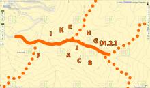
Japanese Radar and AA Gun Positions on Tai Mo Shan
In 2011, the Hong Kong Institute of Surveyors published a special issue of their journal Surveying & Built Environment to commemorate the 70th anniversary of the battle for Hong Kong. One chapter by Lawrence Lai, Ken S.T. Ching, and Y.K Tan provides a map showing exactly where the 12 radar sites were located in a cluster atop Tai Mo Shan. I imagine it was actually all one site with multiple arrays and antennas. The map also shows the location of three Japanese AA gun positions atop Tai Mo Shan. I remember seeing the remnants of these positions when I hiked up Tai Mo Shan years ago. According to the chapter, the positions were built by POWs. --Steve
HKIS
Thanks Steve, good tip.
I see that issue of their journal is available on their website:
http://www.hkis.org.hk/hkis/general/journal/SBEvol21b.pdf
The map is on page 88.
Regards, David
Re AA gun location
Hi David,
I think I may have reached the AA gun sites. I found three sites with boulder boundary walls. They could actually be spotted from the bush fire lookout.
More later. Have to chow down a bit. Just got down through Lin Fa Shan/Shek Lung Gung/Chai Wan Kok......
T
Re AA gun location
Good news there is still something to see. Please let me know when you're next heading up that way and I'd like to join you.
Regards, David
Re: WW2 Japanese Radar Station on Tai Mo Shan
Hi David,
I went up again yesterday, a bit earlier this time. The Radar sites seemed spreaded out in a bigger area of the slopes. Couldn't locate them all this time. For the ones I passed by they seem to have the same boulder wall characteristics as the AA Gun emplacements. But many of them are much overgrown, literally. The walled up area are basically a tropical forest of its own.
A few of them remained opened, with a bigger one with some brick wall with concrete reinforcement. If we go next time, I suggest to go further up Tai Mo Shan Road to try and get a better view of the site before going down for a closer inspection. Those artificial shapes would be difficult to miss from above.
T
.
Japanese Radar Station on Tai Mo Shan
For interest, part of an Intell Report (NA Kew, WO 208/750A, dated 14th Sept 1945).
Tai Mo Shan: An Air Intelligence Unit (radio location) 113 strong is at the top of the mountain. The road leading to it is nearly 9 miles long. Construction started in Jan 1944 and with camp buildings was finished in Aug 1944. 3 Coy's of Japanese Engineers from Canton with 800 coolies were employed. The rains necessitate frequent repair as the road is not surfaced.
The main installation of 1 Transmitter and 4 receivers is serviceable. Each receiver searches a 90° arc. The power is supplied by a 75W 200 Volt AC diesel driven generator.
Japanese Radar Station
Good find, thanks. I've updated the completion date.
Regards, David
WW2 Japanese Radar Station on Tai Mo Shan
Hi David,
One minor finding elsewhere. I browsed through the Hiking booking concerning War relics in the New Territories by Mr Yip and found he did not have any entries about this site and the AA Gun emplacements. Will try to check out Tim Ko's book at the Library later for this.
T
Photos
Thanks to Philip Cracknell, who writes:
There are a couple of photos in Gordon Alderson's History of RAF Kai Tak (1927-1971) of the Japanese receiving heads at the Japanese radar station on Tai Mo Shan and of the Japanese accommodation at the radar station. There is a copy of this book in HKU HK 355.0942 A36
I see the Public Library also has a copy (https://webcat.hkpl.gov.hk/lib/item?id=chamo:1735146&theme=WEB), which I've just requested.
Then & now photos
Tai Mo Shan WWII Japanese sites
Hi There,
Had been browsing aerial photos these days and I noticed a few blobs east of the sites we visited quite a few years back.
T