Current condition
Ruin
As mentioned in the Mt Nicholson thread, I came across this PB back in 2000 and have never been back since.
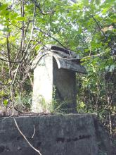
It's to the South of the old Mt Nicholson governemnt apartments, now demolished for the new Wheelock development. I remember the PB being located on a flat, slightly elevated piece of ground, with steps leading up to it. I recollect it being fairly exposed, i.e. not dug into the hill. Someone had cultivated a garden in the flat ground beside it.
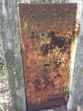
The heavy door was lying nearby, but other bits of iron work were still in place. From memory I think it was a PB design and not an artillery observation post.
Happy hunting!
HillWalker


Comments
re; Mount Nicholson
Hi Hillwalker - I know exactly what you're referring to; I've wondered about that but I always figured it was something to do with the water tanks next to it; the concrete bunker-like structure was always flooded. If it's still there (possible), I'll have another look
Re: Mount Nicholson
Hi there,
The location is now an active construction site. The contractor might have already cordon off the road.
Best Regards,
T
re: Mount Nicholson
You were previously able to access that area from Black's Link by climbing down a gully - the light green patch next to the location marker is the old water tank site. That was owned by the government and I don't know if it's been included or demolished as part of the new works
Re Pill Box
Hi 80sKid
Glad it rings a bell.
The structure I remember certainly wasn't a pump room or utility building. Although it was some time ago I remember inspecting the gun ports with their heavy, rusting shutters. I also remember the solid steel door lying on the ground outside. I can picture its crude but effective bolt in my mind.
You might be able gain access from Blacks Link by crashing downhill through the undergrowth. Alternatively, take the long path from Wong Nai Chung Gap. Although you could walk all that way only to discover it's fenced when you arrive.
Good luck!
HillWalker
Actually it's an AOP
I revisited this "pill box" after first stumbling across it more than ten years ago.
Obviously it's an artillery observation post and not a pill box. And the door is where it should be and is not lying on the ground as I mentioned above. So I got that wrong.
But otherwise it's pretty much where I remember it, on a ridge above the reservoir which is directly behind (South of) 103 Mt Nicholson Rd.
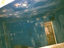
It's actually the cover of the NE observation port which is missing. Looking at the apparent bullet holes inside, I wonder if the cover was blown off in battle and shots fired through the opening. (Pure speculation.)
The chains that used to hold the bunks are still attached to the walls.
Does anyone know if the blue colour paint inside is original? There are signs people have slept in there in recent times and they may have 'redecorated'. But it seems odd to paint the walls and not paint over the bullet holes.
HillWalker
re: Mt Nicholson
Great photos HillWalker - it wasn't the structure I was originally thinking of. I think (bearing in mind this was more than 25 years or ago) that when I lived there as a kid there was an old woman living there. I recall there was always a couple of dogs around the building and she was never pleased with us wandering around, so I don't remember having a decent look. I'll have to go back and check it out. Maybe other Mt Nick folk remember it?
re: Mt Nicholson
I agree, great photos. I haven't seen a paint job like this before, so it was probably done by a later resident. The damage to the concrete might just be spalling, where the iron reinforcing bars rust, expand, and ping off the concrete above them.
I guess this is the missing "Wanchai" AOP that Rob mentioned (see http://gwulo.com/Artillery-Observation-Posts-in-Hong-Kong). [Update: It is different - for the Wanchai AOP see https://gwulo.com/node/17146]
Regards, David
Wanchai AOP?
Hi David
Thanks. I wonder if it is indeed the Wanchai AOP Rob described. It's sort of, kind of around the corner from Wanchai. If so, mystery solved!
Re the paint, yes I'm sure it's recent. But I still wonder if the marks are bullet holes which affected the blue paint, eg by allowing moisture to seep through ? Wish I'd taken better pics, but I was on my own and was spooked by rustling in the jungle further up the hill (probably a wild pig, or maybe a Gwulo enthusiast!).
Thanks also 80sKid. I think I saw the structure you referred to, next to the reservoir. It looks pill box-ish but I suspect it's something to do with the waterworks.
For anyone who wants to visit, you need to head down from Black's Link as the construction site completely blocks access from Mt Nicholson Rd. I actually exited through the construction site and startled the guard with a cheery hello as I marched out onto Mt Nicholson Rd.
mt nicholson aop
Hi, I went to check this out over the weekend, a nostalgic trip as the bunker is where I used to run around as a kid. I've been reminded it was a not very friendly old man who lived there with his not very friendly dogs. You can the remnants of a lean-to he built which was since collapsed, while most of his stuff is still inside the building or scattered down the hillside. Going there now it's hard to imagine what it must have been like to live there in the jungle.
I think both shutters for the windows were intact previously. I found the one that's fallen out, looks like the root of a tree pulled it out rather than a Japanese soldier.
As for the bullet holes, it's hard to tell. There's no damage outside the building, while the holes inside had been plastered and painted over; the paint has since fallen off. Anyone found any reference to the AOP? Whether used or abandoned during the battle. Its siting makes sense, it's set back on the top of a ridge above what was a military camp, while it had a good view across to Mt Cameron and Kowloon. It's now firmly in the jungle which is liberally decorated with spider webs.
Geo Update
Visited this AOP two weeks back and took more accurate GPS readings. It's at Lat. 22.2617915 Long. 114.1805785, slightly east of the Aberdeen Tunnel on the map. As usual, it's on the GeoInfo map marked as "R". https://www.map.gov.hk/gm/geo:22.2619,114.1803?z=564
re: Geo Update
Thanks for the correction, I've updated the marker location from the original position at 22.262415, 114.180189