Tymon Mellor’s article "Japanese Radar Station On Tai Mo Shan," first published in November 2014 on The Industrial History of Hong Kong website, presents an illustrated overview of the radar system used at the site and some of the surrounding huts and facilities. It also identifies the existing locations of those huts and facilities. The final photograph on the article’s page has a caption describing a “Water filter bed” and a “presumed to be Japanese communal bathing arrangement.” It shows a double-walled elliptical concrete structure and a round water tank positioned one above the other on high ground. The photograph sparked interest at the time because the location of these structures remained something of a mystery.
The Hong Kong Institute of Surveyors’ journal, Vol. 35, Issue 2 (July 2026), provides a comprehensive study of the area, including additional photographs of the various buildings and detailed descriptions of their functions. On page 45, it suggests that the double-walled structure above the round filter tank was more likely a settling tank than a bath tank. With the help of the 1945 and 1963 aerial maps available on hkmaps.hk, we can now identify where the original structures were located.
Condition at the last visit (2017):
- Settling Tank: Demolished. No longer existed.
- Water Filter Tank: In ruins.
Photos that show this Place

Comments
Exploring the site
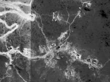
An excerpt from the 1945 aerial map on hkmpas.hk, showing the Japanese radar site and the original structures in the surrounding area.
A cropped close-up of the settling tank and water filter tank, showing a visible path connecting the two structures.
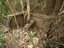
The photographs below were taken during our visit in 2017. We ran up the dry creek in search of the water tank and came across this brick wall.
It turned out to be the wall of the round water filter tank, with a water pipe sticking out at one end of the inner wall.
A view of the water filter from above, showing its depth.
Another angle shows a small opening near the base of the wall, which may have served as a water drainage outlet. The water pipe inlet we saw early on was positioned higher than the filtered-water outlet, suggesting that layers of filter media may also have been placed in the tank when it was in use.
A short distance to the side of the round water filter, we encountered a brick structure of unknown function. It matches the small rectangular block on the aerial map and may have housed a water valve control.
We then found a stone-paved path leading uphill, in a location resembling that of the path shown in the aerial photograph.
Dense, tall grass initially blocked our way, but once we passed through it, an open clearing came into view. The settling tank had long since been demolished, although some scattered remnants of bricks remained on the ground.
The absence of trees or dense vegetation in the clearing suggested that the old structure’s concrete base may have hindered their growth by preventing them from taking root, especially in a high ground area.