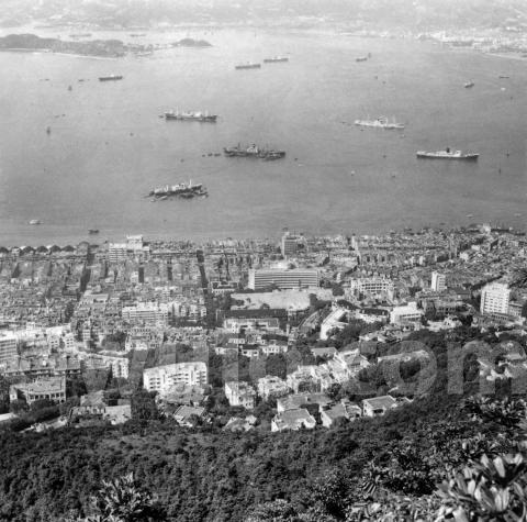
This week's photo looks out from the Peak, over the city and harbour towards Stonecutters Island. We can tell which part of the city this is from a couple of roads that run vertically up the photo. The one on the left is Centre Street and the one on the right is Eastern Street, so we're looking out over Sai Ying Pun.
Usually the tourists at the Peak focus their cameras on Central, so I'm always glad to find a photo of some other part of town. Fortunately I also have another photo with a similar view, but taken around 1900:

If we compare the two photos, the most obvious change is in the shipping. The large sailboats in the 1900 photo have all gone by the 1950s, as have the many smaller sailing junks that were near the shore.
There are some big changes among the buildings too, but to see those we'll need to get closer:

These show the area around the northern end of Eastern Street (1900 view at the top and the 1950s view below). Connaught Road West runs along the seafront at the top, then the crossroads a little way inland marks the junction with Des Voeux Road West. The strip of land between those two roads was still very new in the 1900 photo, as it had only been reclaimed a few years earlier. It's interesting to see the different styles of building on either side of Eastern Street: three storeys to the right, but much smaller two-storey buildings on the left. I associate two-storey buildings with much earlier in the nineteenth century, so I wonder why they'd have built them on this new land, instead of building the larger three-storey buildings? Were they quicker to build and so quicker to start recovering the costs? And how long did they last? By the 1950s photo we can see that the two-storey buildings have all been replaced by newer four-storey buildings.
Moving a little further inland and uphill along Eastern Street, we come to a cluster of hospital buildings:

Here's how they are labeled on a 1901 map of the area [1]:
- 1a - Venereal and Fever Wards
- 1b - Not labeled
- 1c - Civil Hospital
- 1d - Isolation Hospital
- 1e - Not labeled
- 1f - Superintendents House
- 1g - Medical Staff Quarters
In the 1930s, the new Queen Mary Hospital had opened out at Pokfulam, so this area was no longer the center of government healthcare in Hong Kong. Despite its downgrade, in the 1950s the area continued to have a medical focus:
- 2a - The building marked 1a is still standing, though unfortunately I don't have a detailed map to know its function.
- 2c - This new building is the second generation of the Tsan Yuk Maternity Hospital, which relocated here from the original site over on Western Street. It is built on the site of the old buildings 1b & 1c, and was completed in 1955. (That's the date I'm using for this photo, but if you can identify any buildings that date the photo to later than 1955, please let me know in the comments below.)
- 2e - The buildings at 1d and 1f have both been demolished to leave a large open area. Today the open area is the King George V park.
- 2g - Something I hadn't noticed before is that the building in 1g was extended to the right / east at some point, roughly doubling its size. Its function had changed too, and in the 1950s it was used as a mental hospital for female patients.
Moving uphill again, we come to several of Sai Ying Pun's famous schools:

Building 1a housed the "Diocesan School" according to the 1901 map. Today we know it as the Diocesan Boys School, or DBS. They moved over to Kowloon in the 1920s, and at some time between then and the 1950s the site was re-developed and a much larger school, 2a, was built. It is still there today, and is known as the Bonham Road Primary Government School.
Uphill again, and at 1b there is a strip of open ground between Park Road and Lyttelton Road. That open area was part of the West End Park. The main building of the new St. Stephen's Girl's College was built on that site and opened in 1924. It is shown at 2b in the 1950s photo, and it's also still there today.
Another building that's worth a closer look is over in the bottom-right corner of the 1900 photo:

I've highlighted the three roads to help identify them:
- red - High Street
- green - Bonham Road
- blue - Park Road
By the 1950s the open spaces have been covered with buildings, including one that is an odd jumble of towers and turrets:

Here's a clearer view of it, as seen from Bonham Road:
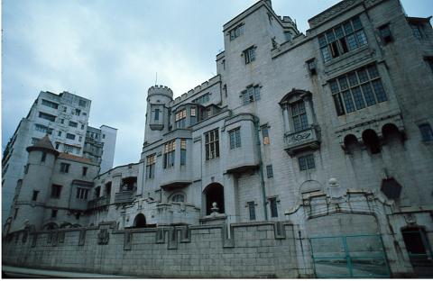
It looks like something you'd find in Disneyland, but it was actually a private residence called Euston, one of several 'castles' that Eu Tong Sen had built in Hong Kong.
That's the edge of the 1900 photo, but the 1950s photo shows buildings even further up the hill, including this cluster around the junction of Conduit Road and Po Shan Road:

The building at the bottom left has an unusual outline, with it's top-left corner a series of steps. That helps identify it, as the modern map shows the building is still standing, number 43A Conduit Road. The middle building, Haddon Court, is a more recent addition, but number 41B also appears in both the 1950s photo and today's map.

Today, the next building to the east / right is Realty Gardens. It was built on the site of The Fairview at 41A Conduit Road, and we just catch the edge of The Fairview site in the photo:

The terraces and pavilion were part of its gardens.
The Fairview had a couple of claims to fame in the 1950s. For most of that decade it was home to the Foreign Correspondents' Club (FCC), and site of some memorable parties. It became well-known outside of Hong Kong too, not for the FCC, but when it was used as a location in the hit movie, Love is a Many Splendored Thing. It was used as a hospital in the film, and the pavilion made a few appearances - you can see it in these stills from the film at centre-right and bottom-right:

If you can spot any other points of interest in these photos, or add any memories & information about them, please let us know in the comments below.
Gwulo photo ID: A411
References:
- Plan of Victoria, Hong Kong. [In 29 sheets.] Public Works Department, Hong Kong, 1901. 60 feet to 1 inch. Held at the UK National Archives, their reference: CO 700/HongKongandChina20
|
Also on Gwulo.com this week... Only four more pages to go to finish typing up the 1923 Juror's list. If you can spare 30 minutes, please help us to type up a page. New posts, pictures & comments:
Readers' questions:
|
Comments
More to see
There is more to see on the western side of the 1950's image. On the very left side is Centre Street as identified by David. West of it (if I see it correctly) are the West Point Godowns . I cropped a detail from the 1950 image:
PASTED IMAGE DELETED
The building on the right side is Kwan Yick Building Phase 3 . It was built on the place near the former China Merchants Pier. East (right) of it is Western Street.
As expected, all old buildings like West Point Godowns are gone. And another detail, land has been reclaimed on the western side.
Hospital Hill Development to 1900
Below is a summary of the important developments of Hospital Hill until 1900 taken from my own research
The earliest picture of the Hospital complex I have found is the Lai Afong photo of Sai Ying Pun taken 23rd September 1874 after the Typhoon. I have reproduced part of it below:
The building labeled 0a is an old school building taken over for the Lock Hospital in the early 1860's. This hospital treated men and women for venereal disease. The name is believed to come from the practice of locking the women in to prevent them infecting others while being treated.
By 1874, the Lock Hospital had moved into a new building (constructed approximately 1870), further up hospital road which is the large 2&1/2 storey building labeled 0c. Just behind this new Lock Hospital the roof of the original civil Hospital can be seen. This building was essentially destroyed in the 1874 Typhoon, necessitating a move to Hotel d'Europe on Hollywood Road. In 1878 The Hotel d'europe was destroyed by fire so the Civil Hospital moved back to Hospital Hill taking over the New Lock Hospital building built on the site of the original civil hospital here as well as the older Lock Hospital on Hospital Road. The Female Lock hospital moved back into the old schoolhouse on the corner of Hospital and Eastern Street at 0a. There were many complaints about the state of this building.
0e, the large area of flat ground just to the south of Hospital Road and where today King George V Park is, hosted Smallpox Wards at the Eastern Street side by the early 1880's. The small pox wards were expanded greatly in 1887 with Temporary Matsheds due to the small pox epidemic that broke out in November that year. The middle area at 0e became the Hospital Gardens & Recreation ground for convalescing patients and the part adjoining the Berlin Mission House would be used for the Superintendents House (Completed 1885)
Thee main Civil Hospital building (0c) was expanded to three storeys, the work being completed in early 1887. In 1887. On 01 September 1887, the Government abolished the compulsory medical examination of women, however many women continued to attend the examinations voluntarily. (Venereal disease infections increased significantly in subsequent years). The Female Lock Hospital was due to move back to the new building completed in 1878 but this was delayed as the building was required for nursing Quarters.
In 1888 construction began on European Staff Quarters South of High Street, as well as laboratories
The Chinese Staff Quarters were completed in early 1891. These were built at 0b and are the building 1b in the below photo. In November 1891 the Chinese Lunatic Asylum opened complementing the European Lunatic Asylum opened in 1886
A Vaccine Institute was opened on Garden Road in the October 1892.
The Lock/Women's Hospital became the Venereal Wards in 1893. Inspection of women was discontinued at the end of 1893 by order of HM Government in London
A Maternity Hospital (1d in the photo below) was opened on the site of the old Small pox wards in 1897. Initially it was used as a infectious disease hospital
By 1900 when the upper of the two photos below was taken, Hospital Hill had the following buildings on it:
1a: Venereal & Fever Wards
1b: Chinese Quarters
1c Main Hospital
1d Isolation/Maternity Hospital
1e Hospital Gardens
1f Superintendents House
1g Medical Staff Quarters
Sources for the above information are the annual Colonial Surgeons Report 1870-1900 which can be found here
Thanks for the detailed write
Thanks for the detailed write-up of the history of this area. I'll move it out to its own page, but I wanted to double check the name of the area first. You've used "Hospital Hill" to describe this area, but I've usually seen that name used to describe the hill over in Wanchai where the old Naval Hospital stood. eg a quick search on HKGRO shows the mentions of Hospital Hill refer to the hill in Wanchai. So I wondered if you'd found other sources that use Hospital Hill to describe the area around the Civil Hospital?
Buildings later than 1955
Yeo Wing of Tung Wah Group Hospital in Po Yan Street: completed in 1958. (large white building above the "m" of watermark)
No.1A High Street: first occupancy in mid-1958. (white building above the gap of "o" and "m" of watermark)
No sign yet of No.1C & 1D High Street, which were completed in 1959.
This photo was taken in about 1958-59.