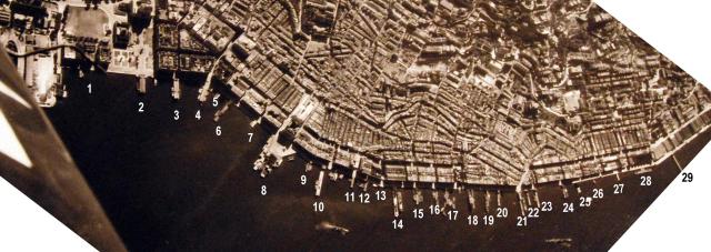
Cropped from Air Raid 1945-01-16 (3)
This is one of the few aerial photographs that show piers from Central, Sheung Wan to Sai Ying Pun. The photo was not taken vertically downwards, therefore the distances between the piers to the west are a bit compressed. Although it’s a photo taken at the end of WW II, the piers look intact and represent piers existing in the 1930s/1940s.
The following piers are identified (names mainly taken from the 1945 map on Gwulo)
1 Murray Pier (3rd generation) [c.1908-c.1955]
2 Queen's Pier (1st Generation) [1925-1955]
3 Central Star Ferry Pier (2nd Location, Connaught Rd off Ice House St) [1912-1957]
4 Blake Pier (1st generation) [1900-1965]
6 Douglas Steamship Co. Ltd. Wharf [????-????]
7 Pottinger Street Pier [1898-c.1965] (Government Pier)
8 Vehicular Ferry Pier, Central [1933-1994]
9 Leung Chung Wharf
10 Osaka Shosen Kaisha (O.S.K.) Wharf [????-????]
12 Government Pier (first generation) [c.1905-c.1965] (at Wing Wo Street)
13 Harbour Office Pier
14 Hong Kong Macau Ferry Wharf (second generation) [1900-c.1958]
15 Tung On/Tai Yip Wharf [c.1924-c.1958]
16 Pasig/Po Tak Wharf [1900-c.1958]
17 Ping On Wharf [c.1924-c.1958]
18 Public Pier No. 17 - British Canton Line / Yuen On Steamship Co. Ltd [c.1924-c.1974]
19 Hoi On / Ming Sang Wharf [c.1905-????]
20 Cheong Wing/Tai Hing Wharf [c.1901-c.1975]
21 Wing Lok / 三角 Pier [????-????] (Macao Wharf)
22 Yuen Un Wharf
23 Permanent Pier No. 6 off Queen Street (Chun On Wharf)
24 Sutherland Street Pier [c.1903-c.1980] (Sai Kong Wharf)
25 Wilmer Street Pier (Ferry to Sham Shui Po)
26 Unknown (Ferry to Tai O & Chung Chau on the 1945 map)
27 Tong Tei Wharf
28 Jardine's Wharf [1885-1981] (Kowloon Wharf and Godown Co. Pier)
Comments
1945 Map
A comparison can be made of the names of the piers in the following map from 1945: https://www.hkmaps.hk/map.html?1945.5
re:1945 map
Thank you moddsey for the link to another 1945 map. Fortunately, practically no change. Only a few piers disappeared or were renamed.
I just want to point out something I learned from Tymon Mellor only last week. That is:don't think the publishing date gives the actual appearance of the area! The map you linked (1945.5) is a perfect example for that - although published in 1945, the survey is from 1930/31. If you look for the vehicular ferry, it is not there - of course, it was built in 1933. If you take the map 1945.4 instead, it is almost the same (and based on the same survey), but the vehicular pier is there. Always look for the small print what is actually shown on the map.
Re:1945 Map
Yes, I noted the same when looking at the old maps available online. The comments made are valid.