This photo was likely taken in the first quarter of the 20th Century, but please leave a comment if you can help narrow down the date. [2025 update: Date identified as 1907-8 in comments below.]
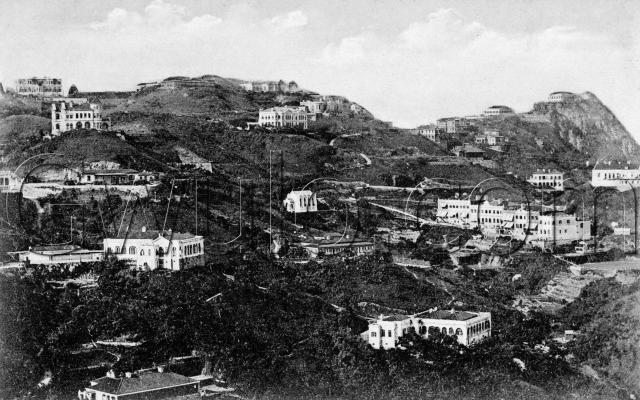
I recognise a couple of the buildings. In the centre, the boxy, white building is the Peak Church.
To its right is a terrace, Stewart Terrace, of buildings on slightly different levels as the hill slopes downward. The Terrace faces west, and if you zoom in you can see that several buildings have their awnings open, keeping out the late afternoon sun.
The photos is an old, split-back postcard, titled 'View of Buildings on the Peak, Hongkong.' The back shows:
Published by M. Sternberg, Stationer & Bookseller.
Pictorial Post Card Dealer, 68 Queen's Rd. Central, Hongkong
Reference: A007
Comments
As a matter of fact I
As a matter of fact I do.
Top to bottom, left to right
The Mount (Jardines)
Wellburn (just a bit of it)
Government Villas
Dunnotar (two rectangles but one property)
The Neuk
- into the center ...
Peak Church
Stokes Bungalow (East and West)
The Falls
- off to the right ...
Leigh Tor
not sure if these had names (one of two houses behind the Police Station)
Stewart Terrace
Here is a colour version that is very clear
Buildings on the Peak
Thanks Annelise, I was hoping we'd hear from you!
This must have been a popular postcard of the time, given the different variations available.
Any idea when the original photo was taken? Either from your knowledge of the buildings, or possibly from a postmark if any of these postcards were used?
Regards, David
Re: Buildings on the Peak
Just wondering...is it possible to take a "now" photograph to contrast with the "then" ones in this topic? :)
Re: Buildings on the Peak
David, is it possible to arrow point the various buildings that Annelise has mentioned onto the postcard/photo? Best Regards.
Facebook Group
Does Gwulo have a way I can "tag" the buildings in the photos like you can on Facebook?
If not, if someone starts a Gwulo group on Facebook I'll be happy to post what I have, properly tagged.
Best,
Annelise
Take the bus to Matilda Hospital
Take the #1 minibus to Matilda Hospital and look back. If there is a good shot, you will see it from the minibus.
Or, go to the Peak Fire Station, and just walk along Mt. Kellett Rd. There are two sheer drop-offs that should offer nice photos opportunities.
Also, go to Google Books and type in "Peak Church". There is a photo at a similar angle, but taken about 20 years earlier in Voices from the Past: Hong Kong, 1842-1918, By Solomon Bard. (pay no attention to the caption in the book. It is not entirely accurate). Get your bearings off the Peak Church and Stokes Bungalow center right to compare to these postcards.
Best,
Annelise
Tanderagee - postcard is after 1905
According to the Public Records Office, the land for the house at the very top right just below Mt. Gough Peak, Tanderagee, was leased by the Government in March 1905 to Alfred Bryer, Architect with Leigh & Orange (CSO 1/217/17 & Jury list). So it cannot be before that date.
Arrows to the buildings
Moddsey, if you view the larger version of the photo, the boxes Annelise drew around the buildings are clearer.
Annelise, maybe a bright colour like red would be a better choice if you're doing something similar in future?
Tagging photos
Hi Annelise, you can add tags to photos, forum posts, etc. Though currently only the author can add tags. eg you can add tags to photos you've created, but not to photos I've created.
If you're tagging buildings that appear in photos, there's a better feature: places. They are like tags, but are specifically for places and buildings. There's a full description of how they work and how to add them here.
Let me know if you have any trouble using this feature.
Regards, David
Date of photo
Thanks. Based on your info I'm guessing the range is 1905-1925, so I've set the date to 1915 for now. If anyone can narrow down the date further, please let us know.
Tagging buildings
On Gwulo I can only figure out how to match a building/location to the Google map - not to the photo itself. So, I've posted it onto my Facebook page, and tagged it there. I can't zoom in as well as Gwulo can, but it is a start, and I've added the actual Rural Building Lot numbers so they can be cross referenced to other postcards/photos. I'll add one more from an earlier time. Here is the first one.
http://www.facebook.com/photo.php?pid=30574342&id=1358598248
Re: Tagging Buildings
Thanks Annelise for the confirmation of the buildings and rural building lots. Cheers.
1880s Buildings on the Peak
Peak Church is in extreme right middle.
re: Tagging Buildings
You're right, we can't tag onto the photo. It's a useful feature to have with photos like this, so thanks for linking us to your tagged photos on Facebook.
Earlier photo - only Peak Police Station
"Place" feature
As you can see, I figured out how to use the "place" feature. I've been having a very fun day of posting ! :)
re "Place" feature
Yes, I've just been looking through all the new places and images. You've certainly been busy!
In fact it's been a busy couple of days for the website - thanks to everyone who has posted.
Regards, David
Peak School
Hi David,
Your picture doesn't have the original Peak School in it, now Peak Fire Station (www.gwulo.com/node/5230). Its future site in your photo is between Government Villas and Dunnottar. The tender for its construction was awarded in 12-1914, with completion and occupation in 9-1915 (PWD Report 1915), so your photo must date from before site clearance which was probably in early 1915.
Thanks for the extra clue. I
Thanks for the extra clue. I'll set it back to c.1910.
Regards, David
Buildings on Mount Gough
The date that Davids photo was taken can be narrowed down further by reference to the buildings standing on Mount Gough, the rocky peak in its top right corner.
Coming down the ridge line from the peak itself as far as Plantation Gap, the buildings in sequential order are, the house called "Mount Gough", "Brockhurst", "Bicton/Burrington" (one building) and "Red Hill". Additionally, the building beneath Brockhurst as we look at it is "Kirkendoa".
Of these, "Brockhurst" was constructed way back in the 1880's so doesn't help us with dating this pic. Later, "Kirkendoa" was completed in 1897/8 (PRO, see http://gwulo.com/node/5184). Red Hill was completed by 1898 (mentioned in 1898 Peak Directory), and "Bicton/Burrington" by 1899 (mentioned in 1899 Peak Directory & Ladies Directory), but I don't have their construction dates. The photo was therefore taken in 1898 or later.
By 1909 both the house called "Mount Gough" and its immediate neighbour "The Ridge" (https://gwulo.com/node/5741 , which stood between the house called "Mount Gough" and "Brockhurst") had been built as both are marked in the 1909 Peak Map. However, Davids photo only shows the house called "Mount Gough", not "The Ridge" - the future site of which is vacant. The photo must therefore have been taken before 1909 by which time both would have been seen.
To summarize, the photo was taken between 1898 and 1909.
Genesis of the "show places" feature.
This shows a post I made in 2009 ...
Updated date range of photo
The completion dates for the houses named “Mount Gough” and “The Ridge” have been established with some confidence and are helpful for dating this photo.
“Mount Gough” (the house) is clearly seen in the photo as the highest building on the triangular-shaped peak in the top right corner – Mount Gough (the mountain). It looks complete. Completion was sometime between August 1907 and June 1908, so the photo could not have been taken earlier than August 1907.
Immediately next on the left and slightly lower down the ridge line from “Mount Gough” (the house) is a vacant flat terrace where “The Ridge” would soon appear. I’m sure it hadn’t been built when the photo was taken otherwise it would be clearly seen. Either construction hadn’t started or was in its earliest stages when the photo was taken. Completion date was sometime between June 1908 and Feb 1909. Assuming it would have taken at least three months to build, the photo could not have been taken later than December 1908.
So the photo was taken sometime between August 1907 and December 1908. Corrections welcome.