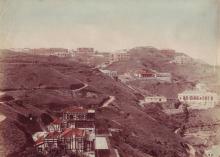
Current condition
Demolished / No longer exists
This appears on the 1909 Map, with the address "38, The Peak". [2020 update: The address on the 1909 map is correct, but they labelled the wrong building. #38 is actually the building they've marked #40 - see comments below for details.]
It's not clear from the map whether it's a single house, "Tai Koo Peak House", or is in two halves, "Tai Koo" and "Peak House".


Comments
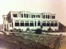
Taikoo House
There's currently another Taikoo House, near to Wanchai Gap.
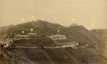
Note the distinctive narrow mounds on each side
View from Taikoo's Peak House
First photo in series:
Peak House/Cloudlands
There seems to be a problem with these two houses. On the 1909 map, Peak House has the number 38, Cloudland No. 40. Cloudland is closer to the edge compared to Peak House. On the 1912 peak map, it's the other way round. On this 1912 map, there is handwriting on it saying "Peak House (Swire's)" . So maybe the 1909 map is labelled incorrectly and Peak House stood where today's Ridgeway is.
re: Peak House/Cloudlands
Well spotted!
Looking at https://gwulo.com/node/34922, the building listed as "Peak House (Tai Koo)" was numbered 38, tyen 112, then 350 The Peak.
A 1956 governent map of the Peak shows #350 was the western building, roughly where Ridgeway is today. I've moved the marker to that location.