Hill Side 1 & 2 is listed in the key to the 1899 Peak Map on RBL 6, together with Clavadel and Haytor. However, the 1912 and 1924 Peak maps shows Hill Side 1 & 2 on RBL 8, together with Haytor, Creggan and Strawberry Hill. I don't know which is correct.
I haven't been able to find the auction dates of RBLs 6 or 8. However, RBLs were normally auctioned in sequential order. As RBLs 1-4 were scheduled for auction on 30 September 1878, and RBL 9 was scheduled for auction on 17th March 1879, the RBL's 6 & 8 auctions were probably scheduled for sometime between those dates. If so, construction of Hillside 1 & 2 would have started sometime after 30th September 1878.
The earliest mention of "Hill Side" I have found so far is in the 1891 Ladies Directory which states that Mrs. W. Judd was resident thereat. Construction should therefore have been completed sometime before or in 1891.
I've chosen the mid-point between 1878 and 1891 , i.e. 1885, for the approximate construction completion date.
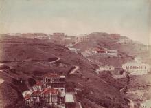
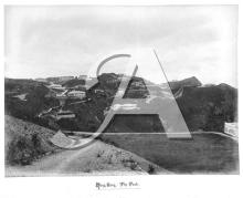
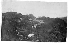
Hill Side appears in old photos as a large two-storey building near the bottom and to the west of Bluff Path.
Photos that show this Place
Comments
Merge with this page
See https://gwulo.com/node/5353#17~0.00000~0.00000~Map_by_GovHK-Markers~100
slso see … https://en.m.wikipedia.org/wiki/History_of_Victoria_Peak
snd … https://search.grs.gov.hk/en/arcview.xhtml?q=Rbl+6&eid=T6WRif0McdPYeNqw…
”RBL NO. 560 - (FORMERLY RBL NO. 8 SEC. A S.S. 1 & R.P. & RBL NO. 6 SEC. A S.S. 1 & SEC. D, SS. 2 STRAWBERRY HILL - APPLICATION FOR RENEWAL OF CROWN LEASE IN RESPECT OF .....”
Also search “R.B.L. 6”
Also …
Record ID HKRS265-11D-3501-8
Title
R.B.L. NO. 6, S.A, S.S. 1; R.B.L. NO. 6, S.D, S.S. 2; R.B.L. NO. 8, R.P; R.B.L. NO. 8, S.A, S.S. 1- ASSIGNMENT, ATTESTED COPY
Original Reference Number
68225
Form Part of
HKRS265-11D Surrendered Title Deeds
Date
29.4.1919
Hill Side
Hi Annelisec,
My apologies for overlooking the "place" you had already made for this building. I may have missed it because its "place" marker does not appear on the "Map of All Places", which may be because the map at the head of the "place" page is blank. Also, perhaps because searching is more difficult with different formats of the name - "Hillside" and "Hill Side". I used "Hill Side" as per the maps.
Thanks for your link to the GRS site. To be honest I've always had difficulty understanding these land related documents. What do the ones you have highlighted mean in layman's terms please?
I note the linked wiki page states that Hill Side was on RBL 6. I wonder what was their source document. I'm not saying it was or wasn't on RBL 6, just that I have not yet seen anything conclusive one way or the other.
I've hidden the older page.
I've hidden the older page.