Where: Here's the same view today, looking east from Stubbs Road across Happy Valley:
You have to look carefully to find any matches between the views. The two I found are both on the far side of the valley:
- In the centre of the new photo you can just see the spire of St. Margaret's Church peeping over the top of the racecourse stadium
- And to the right of that you can see the slope of Broadwood Road as it climbs the hill.
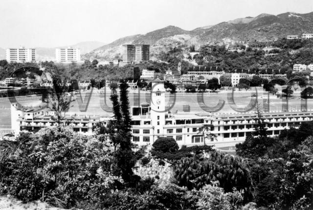
What: In the top-left corner of the old photo there are two buildings on top of Leighton Hill, the Leighton Hill Government Quarters. With clear views east, west and north, they must have been a fantastic place to live.
There had been earlier government quarters built on that site, but they were destroyed during the fighting in 1941. The Leighton Hill ridge formed a natural defensive line against the Japanese who'd landed to the east at North Point and Quarry Bay. The ridge was staunchly defended against repeated attacks, and by the end of the fighting was described as "looking like the Somme" [1].
Remarkably, there is a wartime relic visible on Leighton Hill if you look carefully. Can you spot it? And what was it for? Ifu'll post the answer after the weekend in the comments below - unless someone beats me to it.
Moving further right along the ridge we come to another pair of tower blocks that I don't know the name of. These are newer, with the construction scaffolding still in place. Can anyone identify them?
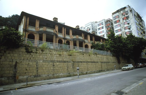
Right again and slightly down, and we get a clear view of St. Margaret's Church. Then opposite the church are the dark roofs of more government quarters. These ran along Ventris Road and survived into the 1980s. Here's a close-up from 1981, taken by Andrew Tse:
Above them is the sloping Broadwood Road that we mentioned before, with several grand houses along the ridge above it. I believe these were part of 'The Ridge' development, which was connected to C.E. Warren. [2]
Looking down from the buildings, the central third of the photo is taken up by the Happy Valley racecourse and its stadium. The grassy area in the centre of the racecourse is marked out with pitches, and we can see several pairs of goals. Would they have played football or hockey (or both) there in the 1950s?
Who: There are several people visible on the pitches. Not enough for a match though, so are they practising? Or were the pitches open to the public for recreational use?
Just in front of the stadium's clock tower are a much less active group. Zoom in to the clearing, where you'll see several rows of graves in the Hong Kong Cemetery.
When: We know the Leighton Hill Government Quarters were completed in 1948. And the Jockey Club's website says that this stadium was "replaced in 1957 with two seven-storey structures" [3]. So we're looking at some time between those two dates. If we can find out the construction date of those two blocks in scaffolding, that will help narrow it down.
What else is there to see in this photo?
Regards, David
References:
- Tony Banham's "Not the slightest chance", page 286.
- Charles Edward Warren
- HK Jockey Club History (look at the entry for 1931 on the timeline)
Reference: A068
Comments
Re: Grassy playground in the middle of the race course
Hi there,
I believe I saw a Soccer Field there in the middle with a small cluster of player near the goal net. I have read somewhere else that the grassy playground was surrendered to the Urban Council for their management and was open to the public. I could not exactly remember when, but I guess some digging into the Jockey Club's history and/or the LCSD should find something useful. That could help to date the photo as well.
Best Regards,
T
Race Course
I believe the Jockey Club held the lease for the land occupied by the grandstands and the racing track only. The vast area of land within the racing track was public land intended for recreational use. This included soccer, hockey and golf, and for a brief period after the war even cricket. The Club was required to provide access to the public, and the normal point of entry was the gate at the eastern end of Sports Road.
The Tote can be seen behind the grandstand building. This, I think, was built in 1951, so that means the photo was taken post 1951.
In the photo, and to the right of the Ventris Road Government quarters, may be seen the Le Calvaire Convent on Wong Nei Chong Road. This was used by the Japanese during the occupation as their Kempetei headquarters for the eastern district. The cells were on the ground floor with no windows, and an inmate for a short period was Sir Vandeleur Greyburn.
The two tower blocks with scaffolding were new Government quarters being built at the southern end of the Leighton Hill site. It should be possible to pinpoint the year of construction - I think it was in the late 1960s.
Leighton Hill Government Quarters (Southern Block)
The southern block of government quarters on Leighton Hill was completed in 1956.
I can't see it clearly but
I can't see it clearly but there appears to be a structure on the hill below and between the 2 govt blocks. A and B block if I recall correctly.
The structure is a ventilation shaft for the ARP tunnels below . We used to play around it as kids in the '60's. Someone had cut the metal bars in an opening at the top so you could poke your head in and look down to what was a long and dark drop.I recall there were other bars lying horizontally across some meters down so even if you got in and climbed down you wouldn't have got very far.
The hill was also home to packs of wild dogs that were occasionally subject to round ups by the USD with long bamboo poles used as snares. These were the source of much amusement as the majority of dogs would leg it and only one or two got caught.
As children we were all aware of the fact that the hill had been a battle ground as were the hills opposite at WNC Gap and Jardines Lookout. We used to tramp up to the pill boxes and play there too.There was still rusty barbed wire and lots of spent shell cases lying around.The pill box door was open at that time.
re: 1950s Happy Valley Racecourse
Gentlemen, thank you very much for the extra information. I've added in the Place for the convent (under its current name, St Pauls).
Moddsey, any chance you can give us a source for the 1956 date? It certainly fits the 1948-57 range mentioned above.
Regards, David
Re: 1956
From Legco archives dated 21 November 1956.
"New blocks at Chater Hall and Leighton Hill have recently been completed."
We have a winner!
Anonymous,
I wasn't expecting anyone to get it, but that's exactly what I was thinking of. There were over 2 km of tunnels dug under Leighton Hill as part of the pre-war Air Raid Precautions (ARP). I wonder if you ever managed a look inside, other than peering down the ventilation shaft?
We can still see several of that network's tunnel entrances today, but I'm not sure if there are any signs of the ventilation shaft left. It's clear to see on the 1950s photo though - imagine the 'G' in the watermark is a clock-face, then the top of the ventilation shaft is the small structure at the 1 o'clock position.
Here's one you can still see today. It's the ventilation shaft for the Star Street tunnel ARP network, and it's on Monmouth Path in Wanchai:
Regards, David
RE: Tote Board
The totalisator was built in 1949.
Re: ventilation shaft
Hi there,
Now that we know what to look for I believe there was another shaft on the Broadwood Road side, just slightly above and behind Saint Margaret's Church.
Best Regards,
T
Totalisator
CM, could you please let us know where you found the 1949 date? Published accounts (e.g. "Pow Mah; a historical sketch of horse and pony racing in Hong Kong") have several references to the date as being 1951. According to that publication a Totalisator Trial Meeting was apparently held on February 3rd, 1951, and it is claimed that the Tote came into regular use at the Annual Meeting on February 24th.
Re: ventilation shaft
Hi Thomas, are you looking at the hillside to the right of the church? If we take the top of the church tower as the centre, the structure is at the 2 o'clock position?
The Leighton Hill tunnel network didn't extend past Broadwood Road, so it shouldn't be a ventilation shaft for that. I haven't heard of any tunnels across the other side of Broadwood Road. I think the next set are up on Blue Pool Road.
Regards, David
Wartime Happy Valley
Thanks to John Bechtel for the following, received by email:
My father, John Bechtel, founded the Kowloon Tong Church on the corner of Waterloo Rd and Lancaster Ave. He lived on Belfran Road in KLT when the conflict began. He was the air raid warden for Kowloon Tong during the conflict and was stationed at the Kowloon Tong Club on Waterloo Road during the shelling start of the battle.
When the Japanese advanced over Lion Rock, the police picked him up and during the shelling they went to the Kowloon Pier and crossed the harbour in a police launch. He was dispatched to Happy Valley to the corner the farthest from the waterfront where the road rounds that end of the racecourse.
He was put in command of a rice distribution store there where rice was given to the local population who had not been able to shop as all the stores had boarded up due to the shelling. He often took me there as a young boy to tell me the story of another young boy who had been hit by shrapnel and had lost his hand and the little boy died in my fathers arms. He shed tears each time he took me there and always told me how bad war is and how precious life is.
He was then given the task of taking rice and supplies to the troops in the area. It was a great risk and the drivers had abandoned their posts due to the shelling of that area. He was in that area when he saw the vehicle go by with the white flag flying and he realized the HK garrison had surrendered. He walked to the foot of the Peak Tram and he and his friend George Padgett of the HK Electric, walked up the peak tram tracks and hid up there until they were captured and sent to Stanley Prison. He was repatriated sometime later which is another story.
BUT he had very vivid memories of the area depicted in your picture of the week.. He received a medal and each year he went to the Cenotaph to commemorate the war and remember those who made the supreme sacrifice.
Re: Ventilation shaft
Hi David,
Yes, that's the one I was talking about. It looked very similar to the other one. Don't know if the ARPs along Blue Pool Road would extend that far.
I checked the HK Maps service search and no portal is listed on the other side of the ridge along Caroline Hill Road. There's one inside the Po Leung Kuk premises though.
Also in the HK Map Service search results and in the on-line map, there are some rectangle markers on different areas on Leighton Hill. I wonder what are those.
Best Regards,
T
Wartime Happy Valley
Padgett was the engineer in charge of the electricity sub-station at the corner of King Kong Street and Shan Kwong Road, and lived in the quarters above the sub-station. I wonder if Bechtel stayed with him, and whether they walked to the foot of the Peak Tram together. It must have been quite an adventure getting past the barracks and dockyard, along what is now Queensway. The worst days in Happy Valley were 21st and 22nd December when practically the whole of the Valley was subjected to very intense shelling, from the direction of Kowloon to the north and Causeway Bay/North Point to the east. Fortunately the Japanese shells seemed limited in their explosive effect.
Re: Totalisator
Could not find any reference to the use of the Happy Valley totalisator in the local papers for 1950.
3 Feb 1951
After the trial use in February 1951, the totalisator was not used until the last race meeting on 2 June. After the resumption of racing on 22 September. the tote was in operation for every race meeting.
totalisator
here is some good footage of the famous totalisator in action, plus other good shots of Central and Tsim Sha Tsui waterfront, sometime in 1950s. Looks like wintertime judging by the light and how dry the hills are
http://www.youtube.com/watch?v=crgH7Jhx_U4
Padgett
Thanks for your note. Yes Dad lived with Padgett during the very tough days and they did walk to the bottom of the Peak Tran and up to the Peak together. They were captured together as well.. Dad never spoke of being interned with Padgett so I assume they were in different camps.. I met Paggett after the war. My family settled in Little Dao Fung Shan right after the war and that is also another story.
Padgett
Hello, John Bechtel. I believe your father and Padgett were in the same Stanley Internment Camp. But your father was repatriated with other Americans in June, 1942. Private G.T.Padgett was in the Hong Kong Volunteer Defence Corps, but he was interned in Stanley Camp instead of being held in a POW camp, and remained there until war's end.
Re: Padgett
John,
Tony Banham's website fills in a little more detail:
The 'TKH' means that after the initial roundup they were both interned at the Tai Koon Hotel. From there they'd have moved on to Stanley, where I think the accommodation for Americans (your father) and British (Padgett) were in different parts of the camp. So they may have still seen each other, but much less often.
I've just been looking at Google, and found your father's book from 1945! Chapter 16 begins:
In ten minutes, all must be ready to leave the Ta Kwan Hotel, by order of the Japanese Imperial Government.
I guess 'Ta Kwan' and 'Tai Koon' are different transliterations of the same Chinese name. On the next page he describes the arrival at Stanley, and confirms the division:
After a trip that seemed endless, Stanley hove into sight, and the internees breathed a prayer of thanksgiving as they scrambled ashore. They were divided into groups, according to nationality. All the available buildings, save one, which had been completely demolished by the direct hiot of a bomb during the war, were turned over to a billeting committee, whose unenviable task it was to assign internees to their quarters.
"Americans this way ... British over here ... Dutch, that way, please ..."
Regards, David
Re: Padgett
Notes from Barbara Anslow by email:
G.Padget
Barbara - Was "Nurse Rose Hobbs" Sister R.E.Hobbs of the HKVDC Nursing Detachment?
Did the marriage take place in Stanley Camp? I ask because it is not recorded in the appendix to Emerson's excellent book on Hong Kong Internment, 1942-1945. I lived in Happy Valley and was a neighbour of Padget pre-war. I recall he had two daughters then, so this must have been his second marriage.
My interest stems from an attempt to identify the VADs who were mobilised and subsequently interned in Stanley. Regards - Jaberu
Simply fascinating
Simply fascinating
Padget and Hobbs
Rose Hobbs did not get married in Stanley Camp, but after internment.
Rose Hobbs was a nursing sister (Colonial) who worked at Tweed Bay Hospital in the camp. According to Greg Leck's Stanley list, there was another nursing sister in camp called Mrs. R.E. Hobbs, who is listed as wife of a member of the HKVDC who was killed during the fighting.
As you are researching the VADs in Hong Kong, I wonder if you are in touch of Jason Wordie who was writing a book about them?
Barbara
Padgett and Hobbs
Thank you very much, Barbara, for clarifying this. I confused the two because VAD Mrs R.E.Hobbs is said to have been named Rosemary. Yes, her husband was B.C.Hobbs of the HKVDC who was killed in action on 22nd December, 1941.
This explains why the names of four other VADs who married in Stanley are listed in the appendix to Emerson's book, but not the name Hobbs.
I know that Jason Wordie has been working on a book about the VADs but have not been in touch with him. I rather suspect he may have run into some difficulty over this very confused subject for which there appear to be few reliable records.
I am most grateful to you for putting me right. Regards - Henry.
Stanley Camp marriages
As a matter of interet, The list of camp marriages shown in Geoff's book does not include those of Roman Catholics - I attended several of them.
Stanley Camp marriages
Most interesting! Do you know where I can find a list of RC marriages? In particular was any of them a VAD?
Similar view, 1946
This Hedda Morrison photo shows a very similar view in 1946:
http://via.lib.harvard.edu:80/via/deliver/deepLinkItem?recordId=olvwork…
Re: Similar view 1946
The 1946 photo shows the first generation Leighton Hill Government Quarters had been razed to the ground. The old quarters at Ventris and Wong Nei Chong Roads can also be seen.
1946 view
the photo also shows well the original layout of the colonial cemetary including its simple gated entrance
Another 1946 view, this one
Another 1946 view, this one taken from higher up the hill: http://via.lib.harvard.edu:80/via/deliver/deepLinkItem?recordId=olvwork…
1949 Totalisator
A few photos of the installation of the multi-speed totalisator at the Happy Valley Racecourse appear in the China Mail dated 1 June 1949.
Update - Work on the totalisator was completed in September 1949. First trial meeting on 21 September 1949. Hong Kong Telegraph 11 September 1949 refers.