A summary of what's new and updated on Gwulo:
Maps
- The Survey & Mapping Office (SMO) have put their collection of historic maps and aerial photos online for all to access. They're a great resource for researching old Hong Kong, so thanks to the SMO for making them available and fingers crossed other government departments follow their lead. Thanks to contributors Tymon for letting us know, and to Herostratus who has written a tutorial to help you get started.
- Next month, map enthusiasts from around the world will be in Hong Kong for the International Map Collectors Society Symposium 2018, which will be held at the Maritime Museum. They have a programme of speakers giving talks on the subject.
- The Symposium is co-hosted by HKUST. I didn't realise they had resources about local history, but their Special Collections website has some very interesting old photos, as well as old maps, viewable online in high resolution.
People
Looking for information about:
- Gwendolene COLTHORPE [1910-????], Stanley Camp internee.
Memories of:
- Billy Tingle
- Norman Dunn MEFFAN [1890-????] and Louis DE ROME [1887-1974], interned at Stanley Camp
- Thanks for the help translating last week's Kew family notes
- Emma ABLONG (née AH KIN) [1865-1913], Arthur John ABLONG [1884-c.1945], Lucy FERREIRA (née ABLONG, aka Lucy Teresa Ablong) [1923-2012], Roberto Augusto FERREIRA (aka Vado; Roberto Augusto Ferreira Sr.) [1923-2010]
- James Henry HAWKETT [1904-1999], Leah Constance HAWKETT (aka Connie) [1899-1957], Wai Lui HAWKETT (née PHILPOTTS, aka Lui, Wai Lui, Wai Lui Yee) [1920-2006]
- Harry Marco LANDAU [1933- ]
- Stanley MASON [c.1890-1960], Marjorie B MASON (née WAVELL) [c.1896-1985]
- Francis King PAGET [1907-????]
- The Knight / Lay family
- I'm sorry to hear that Gordon Randall has passed away. He previously shared thse photos from his time in the Hong Kong Auxiliary Air Force (HKAAF) between 1949 and 1953
Places
- Fan Lau Fort [1729- ] on Lantau
- Pillbox 033a, Cape D'Aguilar [1939- ]
- Various generations of P & O building: 2nd / 3rd / 4th / 5th
- Nairn House [1957- ]
- Hilden [1919- ]
- New Oriental Building [1898-c.1955]
- Military Sanitarium, 504 The Peak [1883-c.1923]
- Where was this c.1940 chicken farm located?
- Herostratus has been documenting the original houses built around Magazine Gap. See this photo for a key:
-
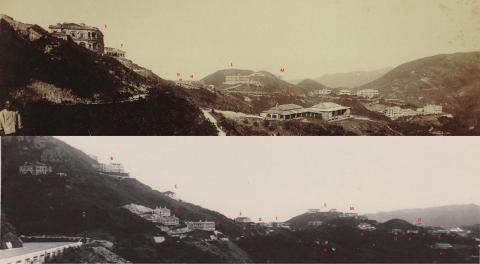
Magazine Gap Comparison c1910 & c1930, by Herostratus
-
Other
- Just six more pages then we'll have finished typing up the 1927 Jurors List and it can go online. If you can spare 30 minutes or so, please help us type a page.
- Notes on Chinese resistance to British occupation of The New Territories
- Were death certificates issued for civilians who died during December 8th and 25th 1941 during the fighting?
- Russian restaurants remembered from the 1950s and 1960s
- After Mike's 1960s driving licence last week, Bob takes us back to the 1950s for his
-

HK Drivers Licence 1957 1.jpg, by Bob Tatz
-
- And Annelise posted her mother's HKID card from the 1960s
-

Mae Pedersen Identity Card 1960, by annelisec
-
Photos


Click to see all recently added photos.