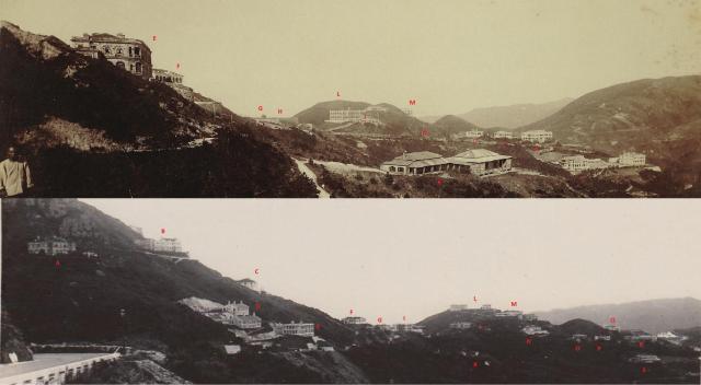
Key to the above photo:
A- Eggesford/Cragholme
B- Lewknor/Taiping/Glasbheinn
C- Government Quarters (as per the 1924 map)
D- ?
E- Craigmin East & West
F- Tusculum/Fairyland
G- RBL 50 - Nos 509-510 -Perevil & Holme Down in bottom pic.
H/I- Durisdeer (site of)
J- Smiths Villa (gw)
K- Military bungalows
L- 520-522 The Peak
M- Cadzow & Fordbank
N-
O- The Kennels (gw)
P- Harford (gw)
Q-
R- Magdelene Terrace (gw)
S- Coombe (gw)
Date picture taken
1910s
Gallery
Shows place(s)

Comments
Harford and The Kennels
Apologies Herostratus,
Above you used my identification of "O" as "Harford" and "P" as "The Kennels". Now I think I was wrong and they should be the other way around, i.e. "O" is "The Kennels" and "P" is "Harford".
I was probably relying on the 1909 map, but for the reasons explained at https://gwulo.com/media/38287, I now think the map is wrong in this regard.