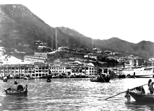
Below is the key for the lettered/numbered buildings. Please comment if you can fill in the missing details particularly the dates that the buildings were build/demolished. The date for the photo may be a couple of years shy of 1900 as the Connaguht Road reclamation has not begun.
A Cringleford (half of)
B Beauregard - London Mission (IL590)
C No 8 Police Station (2nd building) (IL598?)
D London Mission Buildings (IL590)
E Nethersole Hospital (IL590)
F Buildings on Rutter Lane (IL1221)
G Buildings on Hospital Road (IL1221)
H 1-5 Ripon Terrace (IL1217)
I Nettlewood (IL949)
J Hazeldean (IL942)
K No 1 Tank
L Ravenshill(IL930)
M Breezy Point (IL605) -(first building at 2 park road)
N Terra verte? (IL946)
O Tarrawera (IL94?)
P Eastley (IL1216)
Q Hartley (IL1216)
Right of Q: Westley
R Parkview (IL1216)
S Stowford (IL591)
T Berlin Mission (IL607)
U Chinese Chambere of Commerce (IL1244)
V Superintendents House
W Medical Staff Quarters/Mental Hospital
X Chinese Lunatic Asylum/Victoria Mental Hospital (IL688)
Y Civil Hospital
Z Civil Hospital Lower building
1 Belvoir Lodge (IL609)
2 Belvoir Lodge 2 (IL609)
3 Outbuildings of Edenhall (IL609)
4 Edenhall (IL609)
5 Greenmount
6 Craigellachie
7 Larkspur(?)
8
9 Rose Villa (IL1641)
Comments
How on earth did you identify
How on earth did you identify all these places? I'm impressed
1901 HK Map
Thanks Annelisec, it took a while. I mainly using the 1901 map which shows the individual buildings with their names and shapes but I don't have a great copy. I see you have posted some high res scans of some parts of this map, can you tell me where you got them? Also do you know of other version of this map, ether earlier or later? It would be useful in identifying when a building was built or demolished.
I got copies from the PRO in
I got copies from the PRO in Hong Kong but can't find them after I moved. They do that for a small per page fee.
This is the only map I've seen with this level of detail. Set of 29 maps in all. I've linked to the low res pages the PRO has online.
Search Gwulo for "maps on a grid"
Yes, you must have looked at
Yes, you must have looked at a lot of old photographs to work all these out!
Thanks Annelisec, i will head
Thanks Annelisec, i will head to the PRO to see what they have.
Wing Lok Pier
Behind the ship on the extreme right is Wing Lok Pier, used by the Hongkong, Canton and Macao Steamboat Company. The pier opened in 1903.
The photo is also available on MMIS, there dated to 1905.
The reclamation of Section 3…
The reclamation of Section 3 extending the Praya out from Ko Shing Street to Connaught Road was completed in 1897. There is no evidence of any reclamation work having begun in the photo. The large white steamer is at the wharf that existed just to the west of Sutherland Street prior to the reclamation. On the hillside the Tai Ping Shan area has been cleared but nothing has been built on the new layout. The clearance of Tai Ping Shan happened June - October 1895 so I would date the photo to sometime in 1896.