This week's newsletter is a guest post by regular contributor GW:
Introduction
My Mum recently rediscovered a set of slides she’d bought in Hong Kong in about 1986. They’ve been digitized and are posted below in order of the reference codes printed on their frames with their titles. The accompanying comments aim to establish each slide’s “where” and “when”. Many of the “where’s” are obvious, but the “when’s” less so. Dates without a quoted source come from elsewhere on Gwulo.
The Slides
1. XB3, Rickshaws In The Street.

I guess tourists were the main buyers of slides like these, so a set would have to include a pic of that favourite Hong Kong stereotype, the rickshaw, even though they’d ceased being used as a form of transport well before the 1980’s. If I remember correctly, the only ones still around in the mid-80’s were parked outside the Star Ferry, Hong Kong side and, for a fee, were available for a short ride around the concourse area and a photo.
This pic was taken on Connaught Road, Central. In the background, from right to left, are the 2nd GPO Building (1911-1976), Union/Swire House (completed 1962) and St. George’s Building (demolished 1966). That gives a preliminary date range for the photo of 1962 to 1966.
The hoardings on the left are where Queen’s Building stood until replaced by the Mandarin Hotel. The Mandarins’ soft opening was on 1 September 1963, but it obviously wasn’t near completion when this photo was taken, meaning it was probably taken in 1962 or early 1963.
2. XB6, Des Voeux Road, Central.
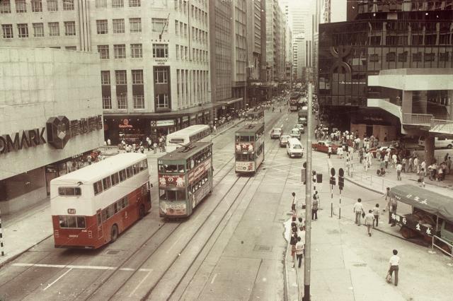
It’s the junction of Des Voeux Road with Pedder Street left, Chater Road right, and was probably taken from the
enclosed footbridge over Des Voeux Road. Helpfully, the names of two of the nearest buildings are visible - The Landmark and Wheelock House. On the right, the dark building with the MTR logo is World Wide House.
The Landmark and World Wide House both opened in 1980 and had Wheelock House as a neighbour until its 1982 demolition, meaning this photo was taken between 1980 and 1982.
3. XB 7, The Hong Kong University.
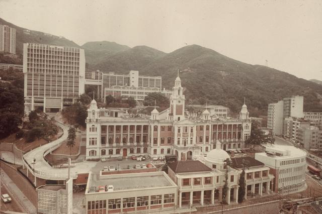
HKU’s old Main Building is the focus of this photo but doesn’t help date it. Directly behind it are the more modern Students Union Building and University Library, with the huge Knowles Building on the left. Infront is the old Administration Building with its dome. All these were present by 1973.
To the right of the Admin Building is a white building that curves around to follow Bonham Road. It’s the Pao Siu Loong Building and was still under construction in June 1973 (1), meaning the photo was taken after that date.
The undeveloped lower slopes of Lung Fu Shan, behind the Uni, were the obvious place to go when the Uni needed to expand. After this photo was taken, the next major project was the construction of the Haking Wong Building and others on the wooded slopes behind and to the right of the existing buildings. By April 1979 construction was underway (2), but there’s no sign of it in the photo, meaning it was taken before April 1979.
Therefore, the slide pic was taken at sometime between 1973 and 1979.
(1). HK Maps website. Map ref. 1973. The site is labelled as, “CIP June 1973”, meaning “construction in progress June 1973”.
(2). HK Maps website. Map ref. 1979. The site is labelled as, “Construction In Progress April 1979”.
4. XB 10, Typhoon Shelter.

The camera is looking west over the Causeway Bay Typhoon Shelter and the largely vacant Wanchai reclamation. The presence and absence of buildings on the left side of the photo helps date it. The Excelsior Hotel (completed 1973) is the most prominent building. Just visible behind and above it is the World Trade Centre (completed November 1975).
A bit further down Gloucester Road towards Central, the British-American Tobacco Factory or its replacement, Elizabeth House, should be visible, but neither is seen. That’s probably because the Tobacco Factory had been demolished, but construction of Elizabeth House hadn’t reached a height visible from this angle. The Tobacco Factory was under demolition in February 1974 (1), the site was cleared but undeveloped in 1976 (2), and Elizabeth House was completed on 27 November 1978. Assuming a huge project such as Elizabeth House would have been visible at least one year before completion, the photo must have been taken in 1977 at the latest.
Therefore, the date range for this slide is between 1975 and 1977.
1. HKMaps website. Map ref. 1974.4 labels the Tobacco Factory site, “Demolition in progress Feb 1974”.
2. HKMaps website. Aerial photo ref. 1976.3 shows the Tobacco Factory site cleared and vacant.
5. XB 15, MTR.
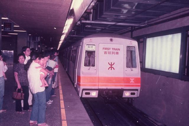
It says “First Train” on the front of the train, so you might think this is a pic of the first journey on the opening day of the MTR - 1st October 1979. But it’s not. Here’s a GRS photo taken at the start of the first journey.
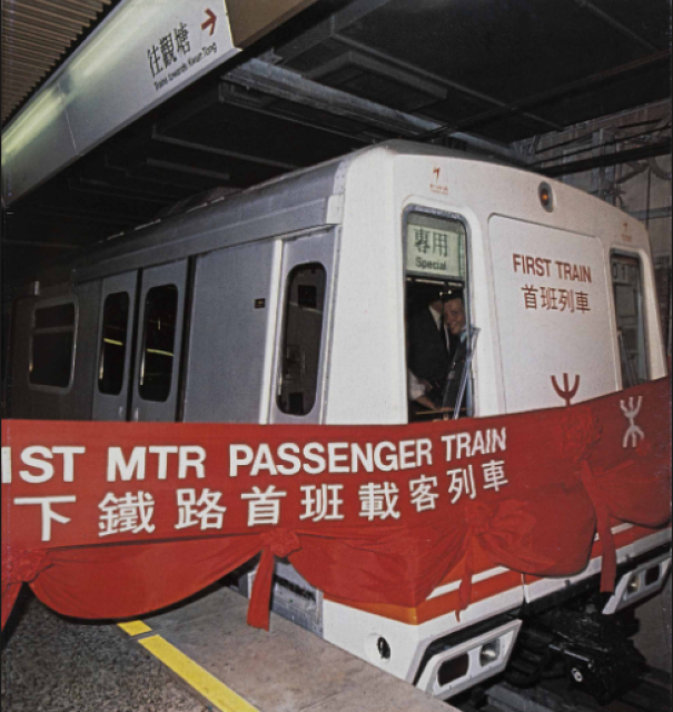
“First Train” is written on the front of the trains in both pics, but the information displayed above the front windows is different. The train in the slide pic was the “05” for “Kwun Tong”, whereas it was the “01” and “Special” in the first journey pic. A possible explanation for the slide pic is that it shows the train that made the first ever MTR journey, but sometime later.
The slide image must have been taken on or after 1 October 1979, but I can’t be more specific than that.
6. XB 17, Squatter Areas.
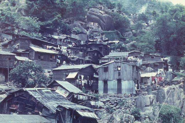
I’ve no idea of the exact location shown here or the date taken.
7. XC 2, Night View Of Kowloon.
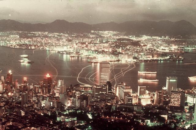
Although the title says it’s a view of Kowloon, the most prominent building is Connaught Centre (completed 1973) in Central. It’d already reached its full height when the photo was taken, but under zoom the upper floors are unlit and have an unfinished look. Also, there’s something clinging to both sides that I can’t identify. It doesn’t appear in photos of the completed building, so may have been used during construction and then removed. The nearly completed building suggests a date of 1972 or 1973.
Partial corroboration of this date range comes at the right edge of the photo – the vacant space to the right of the Furama Hotel. It would shortly be filled by Hutchison House (completed 1974) and the Bank Of America Tower (completed 1975). As there’s no sign of either in the photo, and assuming huge tower blocks such as these would take over a year to build, the photo must have been taken in 1973 at the latest.
Over in Kowloon, the Tsim Sha Tsui East Reclamation appears to be complete, but without buildings. The newly built Sheraton Hotel (completed 1973) can be seen at the bottom of Nathan Road, but its upper floors are largely in darkness. Being a popular hotel, and at night, I’d expect many of the harbour facing guest rooms to have their curtains open and lights on. Possibly the Hotel wasn’t fully open when the photo was taken.
Based on all the above, the photo was taken in 1972 or 1973.
8. XC 5, Cross Harbour Tunnel, Kowloon Entrance.

Nobody’d heard of “health and safety” when this photo was taken. A group of guys are riding on the open back of a truck, two people on a motorbike aren’t wearing helmets, and a pedestrian is casually sauntering out of the tunnel!
The Cross Harbour Tunnel opened on 2 August 1972. Rising above the tunnel portal, but on the other side of the harbour, is the Excelsior Hotel. It appears blurred in comparison to the rest of the photo, so was probably still covered in scaffolding and netting. The Excelsior opened on 20 February 1973, meaning the photo was probably taken at least a few months earlier.
So, this photo dates from late 1972.
9. XC 10, Star Ferry.

Zooming in on the bow reveals her to be the “Oriental Star”. She operated from 1955 to 1973 according to the list at https://gwulo.com/media/15605 .
The photo gives a clear view of buildings on Hong Kong Island. Between the ships’ masts, high on the hillside, the four blocks of Mount Nickolson Government Quarters are all visible. They were completed in 1962.
Again between the masts, but now on the Wanchai waterfront, the two tallest buildings are the Luk Kwok Hotel, and its next-door neighbour, Redifussion House. On the left of Redifussion House is a space where Sheung On House would appear. It was completed on 1 June 1964. Assuming it would have taken at least six months for Sheung On House to go from invisible to complete, the pic was taken in or before late 1963.
So, the photo was taken in 1962 or 1963.
10. XC 11, Nathan Road.
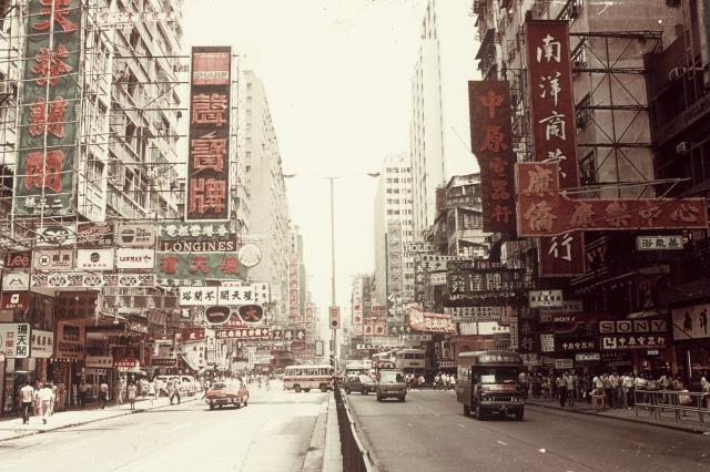
It does look like Nathan Road, but where exactly? A rooftop structure in the distance provides a clue. It’s difficult to see, so here it is highlighted in a blow-up.
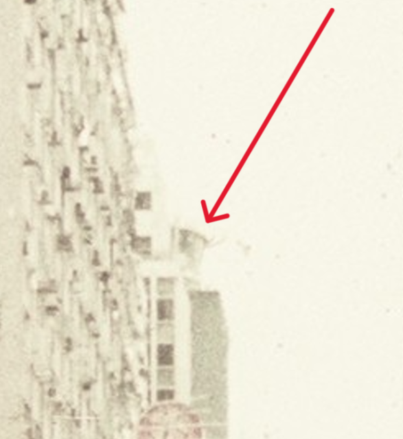
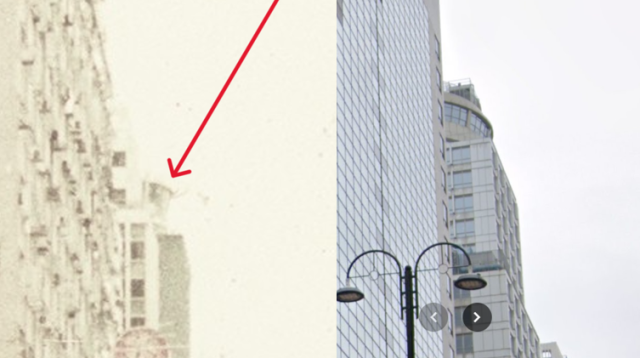
It’s the revolving Juno Restaurant on top of Wu Sang House, 655 Nathan Road, Mong Kok. Google Street View shows it still there when they updated in March 2024. Here’s a side-by-side comparison of the slide extract and Google Street View.
The slide photographer would have been on Nathan Road well south of No. 655. The building on the right edge of the slide photo has the partial name, “City Colleg..” written on it. “City College” must have been a tenant, but I can’t find anything about them online. However, some of the distinctive external features of the building are still present on the Kelly Commercial Building, 570 Nathan Road. Here’s a side-by-side comparison of the building in the slide with 570 Nathan Road from Google Street View.
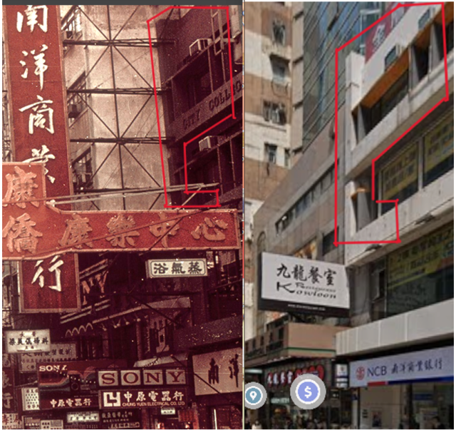
I think the features within the red line are similar enough to conclude that they are the same building, but establishing a narrow date range for the slide has been beyond me. The best I can do is to note that the Juno Restaurant opened in 1967, followed by the completion of 570 Nathan Road in 1975 (1).
So, the date range is between 1975 and the mid-1980’s when the slides were purchased.
(1). Home Affairs Department, Database of Private Buildings in Hong Kong.
11. XC 12, Street Scene At Night.
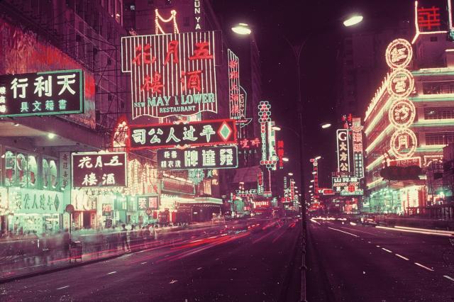
Here’s another one with lots of signs. On the left are two bearing the name “Sunya” (one with the first letter out of view). The “Sun Ya Hotel” occupied Sing Kiu Mansion, later renamed Chan Bok Hing Building, at 629-641 Nathan Road from October 1958 (1) to 1975 when the building was demolished. This means the photographer was standing on Nathan Road, near Shan Tung Street in Mong Kok, looking north.
With one “place” established, it’s much easier to identify others – such as the Ritz Theatre, 625 Nathan Road. Its brightly lit entrance canopy is directly under the word “Flower” on the huge “New May Flower Restaurant” sign. The Ritz opened on 20 March 1953 and closed on 1 Jun 1972. That means 1972 is the latest possible date for the slide, but I’m struggling to establish the earliest date it could have been taken. Best I can do is to note that the neon signs in the slide image are almost identical with the following pic.
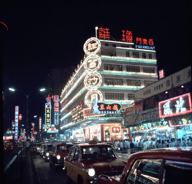
This image was dated 1968 on Flickr, but without reasons given. If correct, then the slide was probably also taken around that time.
(1). Industrial History Of Hong Kong website.
12. XC 14, Jet Landing In Hong Kong Airport.

The jet sports the white cross on a red background logo of Swiss Air, but apart from that I can’t see anything that might help date the photo. Perhaps a Kai Tak expert can assist?
13. XC15, Shanghai Street, Kowloon.
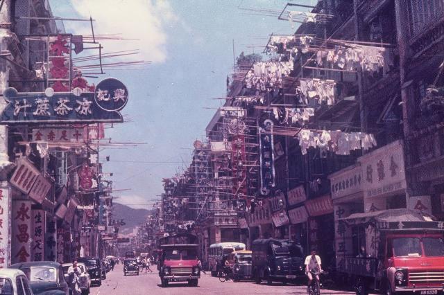
I’ve no reason to doubt that this is Shanghai Street as it’s a one-way street with traffic heading south, but I can’t see any clues to the exact location or date. The hills in the distance seem neither very close nor very far away, so I’ll guess it was taken from somewhere in southern Mong Kok. Again, I’m hoping someone can spot something amongst the numerous Chinese signs to help identify the exact location.
There’s another copy of this photo on Flickr, where it’s dated “circa 1970”, without reasons given, but I’ve got my doubts. I think it may be earlier, considering the ancient looking vehicles and complete absence of high-rise buildings. Early 1960’s perhaps?
14. XC 16, Kai Tak District.

Gwulo has another photo taken from the same location in 1964, but with a wider view and during daylight.
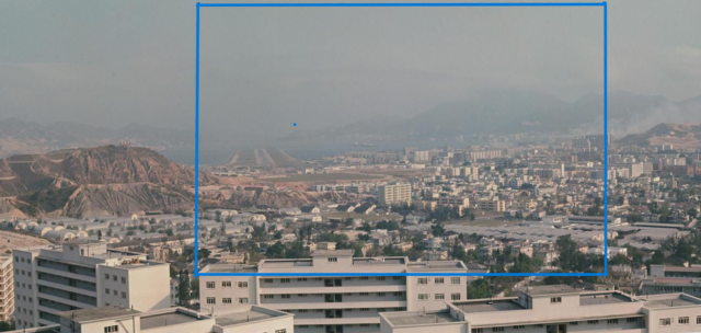
The blue box shows the area covered by the slide photo.
Comments on the 1964 photo tell us it was taken from Lung Chung Road overlooking the rooftops of the Army Quarters at Pilgrims Way, Kowloon Tong, which are also seen at the bottom of the slide pic. Other military facilities in the middle distance are Osborne Barracks and the army school, Saint George’s.
Close comparison of the slide with the 1964 pic reveals a few additional features in the 1964 pic, meaning the slide was taken shortly before 1964.
Although the slide is a sea of lights, a group of dark buildings help to date it. Trace a vertical line down from the nose of the airplane to arrive at a large, multi-storey development in complete darkness. It’s Ma Tau Wai Estate under construction. It consists of five blocks, four of which are visible from this angle. Construction of these four blocks started in January 1961. By March 1962, two blocks (Hibiscus and Magnolia Houses) had been completed and the other two (Rose and Narcissus Houses) were nearing completion (1). All four blocks appear as a large, dark, mass in the slide, meaning that construction had reached multi-storey level but was incomplete.
So, the slide was taken in late 1961 or early 1962.
(1). 1960/61 & 1961/62 Annual Reports of the Hong Kong Housing Authority.
15. XC 20, Kowloon From West.
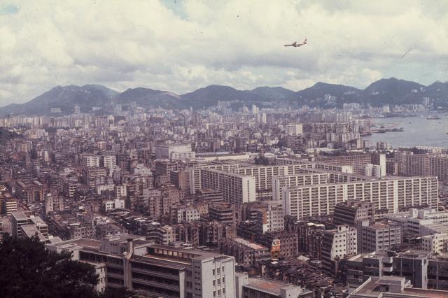
This is the view over southern Cheung Sha Wan to the rest of Kowloon with Hong Kong Island in the distance. I worked in the area from 1983 to 85, so it brought back many memories. Despite my familiarity with the area, I found it difficult to date.
Southern Cheung Sha Wan underwent huge development in the 1960’s. The nearest roofs are Caritas Medical Centre (opened on 17 December 1964, (1)). Running across the middle distance are, from left to right, part of So Uk Estate (completed 1960-63, (1)), Un Chau Street Estate (completed 1969, (1)), Cheung Sha Wan Police Married Quarters (completed 1960 or 61, (2)), and Cheung Sha Wan Estate (completed 1963-64, (1)). Jubilee Building (completed 1935), seen in part on the far right, was a reminder of earlier times.
All the last paragraph tells us is that the photo was taken in 1969 or later. To help narrow down the date, it’s necessary to focus on buildings further afield. The three outlined below are bigger and brighter than their neighbours, so may have been newly built.
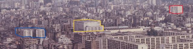
First, the building in the yellow box. Actually, it’s two buildings. The smaller one, nearer the camera, is a Telephone Exchange. The huge one behind is an Electricity Sub-Station. A 1968 map marks both buildings as present, which doesn’t help date the photo, so let’s move on.
Next, the building in the red box. On various maps it was called either the “Hyfco” or “Hyco” Industrial Building, so I think it belonged to the Hong Kong & Yaumatei Ferry Co. Although it doesn’t look like it from this angle, it stood on the Tai Kok Tsui waterfront. The 1972 Survey Sheet labels it as “CIP June 1972”, meaning “construction in progress” on that date (3). The 1972 aerial photo shows what appears to be the completed building (4), suggesting it was completed in late 1972. As the building seen in the slide appears to have achieved its full height, it was probably taken in 1972 or later.
Now to the blue box. It includes the large, white, building called Cheung Yip Mansions and the space on its far side, to its south-east, which is either vacant or occupied by low-rises not tall enough to see from this angle.
Cheung Yip Mansions stood on Pratas Street and is shown on the 1971 Survey Sheet as a completed building (5). Immediately to its south-east, across Pratas Street, was a site labelled, “Kowloon Motor Bus Depot”. It was soon to be redeveloped with the 1972 Survey Sheet labelling the old Depot site as “CIP Oct 1972” (6). The 1973 Survey Sheet updated the situation as “CIP Sept 1973” (7), and the building was completed in 1975 and named Hung Yu Mansion (8).
This 1976 aerial photo captured both Cheung Yip and Hung Yu Mansions (9).
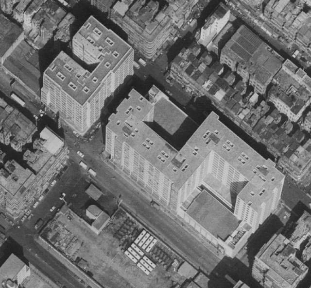
Cheung Yip Mansion is the U-shaped building on the left. Hung Yu Mansions is the S-shaped building on the right.
Considering that the slide image shows the “Hyfco/Hyco Industrial Building” as complete, but Hung Yu Mansions as absent or in its early stages of construction, it was taken between 1972 and 1974.
(1). Wikipedia.
(2). Annual Departmental Report, Director of Public Works, 1960-1.
(3). Map at www.hkmaps.hk , map ref. 1972.2.
(4). Aerial photo at www.hkmaps.hk , map ref. 1972.3.
(5). Map at www.hkmaps.hk, map ref. 1971.
(6). Map at www.hkmaps.hk, map ref. 1972.2.
(7). Map at www.hkmaps.hk, map ref. 1973.
(8). Home Affairs Dept, Database of Private Buildings in Hong Kong.
(9). Aerial photo at www.hkmaps.hk, map ref. 1976.3 .
16. XD 5, Planting Of Young Paddies.
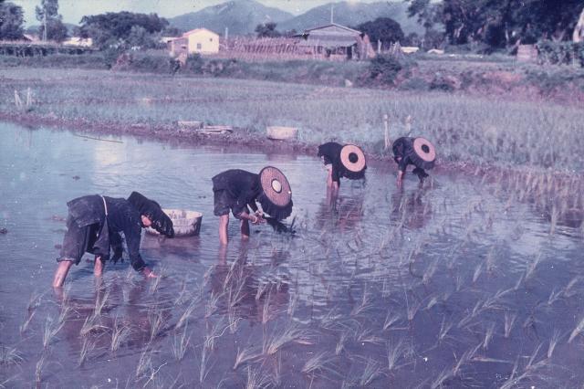
This is the first of four slides showing rural locations, probably in the New Territories, that haven’t been identified or dated.
17. XD 19, Woman Working In The Fields.

18. XD 10, Watering Vegetables.

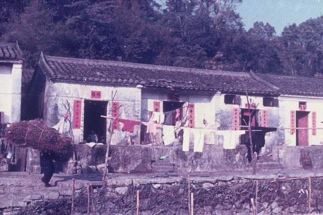
19. XD 13, Villages.
20. XD 14, Female Peasants.
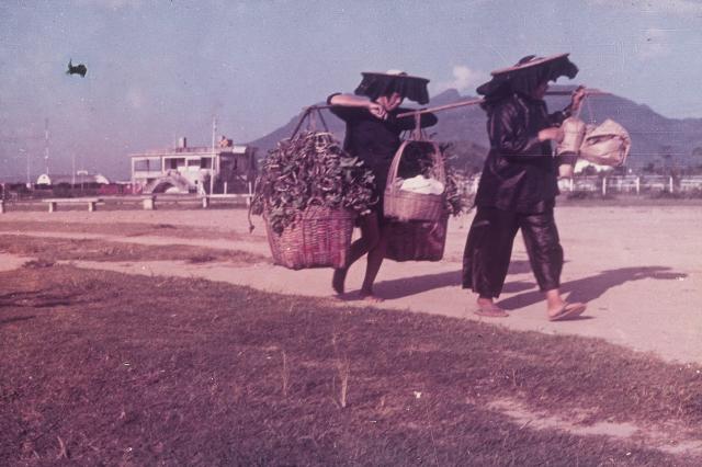
The focus here was obviously on the two Hakka ladies – one of whom is doing all the hard work carrying heavy baskets of produce I can’t identify. Nevertheless, the background is also of interest, especially the Nissan huts and the unusual white building with its external staircase.
I spent ages trying to identify this location and was very pleased with myself when I found a similar mountain ridgeline near Sek Kong. Then I noticed that Moddsey had already posted the same image at https://gwulo.com/media/28292 and correctly identified it as “Tide Cove near RAF Sha Tin”, with Ma On Shan in the background!
This map shows the southern part of RAF Sha Tin.
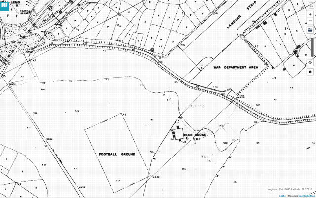
The perimeter of the RAF base is marked as a solid line labelled “WDTP” and “TP” in various places. “WD” probably means “War Department”, but I’m unsure of “TP” – “Trig Point” perhaps. The slide image was taken from the long, straight, path or road running diagonally over the bottom left corner of the map, across the “football field” towards the large white house with the external staircase labelled “Club House”. The Nissan huts aren’t marked on the map but were in the area labelled “War Department Area”.
“Club House” isn’t a name I’d expect for a military building. It’s a term more commonly associated with golf. A possible origin of the name appears in earlier maps of the area, such as this one from 1945.
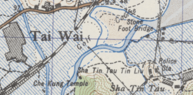
The air base hadn’t been built when this map was drawn but its future site is labelled “Golf Course”. Perhaps the “Club House” building originally served the Golf Course and was repurposed, but not renamed, when the RAF took over?
I haven’t been able to find out much about the Golf Course, but it was mentioned twice in the 1933 newspapers. On 8 June 1933, an article in the Hong Kong Daily Press described a tour of the New Territories and included this passage as the writer drove through Shatin.
“As we came to the railway crossing, I spotted cottages here and there and also the Japanese Golf Course. The links are somewhat on the small side but scenery (sic), this place is as good as Deep Water Bay and certainly better than the course at Happy Valley”.
I wonder how it got the name “Japanese Golf Course”?
The Hong Kong Telegraph of 4 December 1933 reported a golf match between “Shatin Golf Club” and the Country Club. Shatin won. The location was named only as “Shatin”, but I presume it was the Japanese Golf Course as I don’t know of any other course in Shatin.
RAF Shatin was used from 1949 until severely damaged by Typhoon Wanda in September 1962. The slide image was therefore taken at sometime between these two dates.
21. XD 19, Cow Boys, New Territories.

The title mentions the NT, but I don’t know exactly where or when.
22. British-Chinese Frontier (Lowu Railway Bridge).
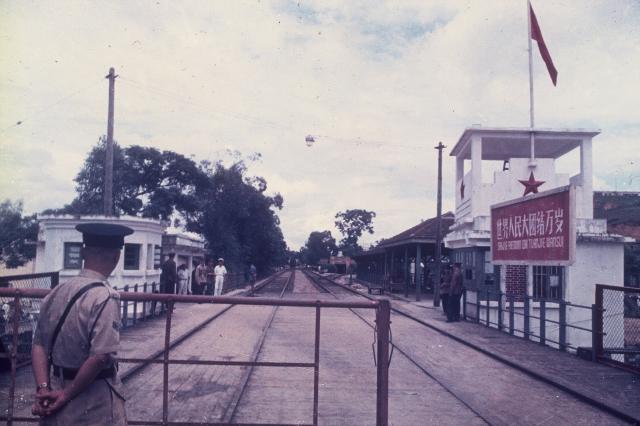
The two white buildings were just inside China. So the photographer was at the northern end of the Lo Wu Railway Bridge peering over the shoulder of a Hong Kong Policeman into the PRC. The large sign in pinyin reads, “Shijie Renmin Datuanjie Wansui”, meaning “Long Live the Great Unity of the World’s Peoples”. The same Chinese characters are emblazoned to the right of Chairman Mao’s huge portrait on the Tiananmen Gate, Tiananmen Square, Beijing.
Later photos show a curved metal roof covering the bridge and both white buildings. It would have been seen in the slide if built by the time it was taken. One source (1), states the roof was added in 1962 to shelter KCR passengers who, in the absence of through-trains, had to disembark on one side of the bridge, walk across, and embark again on the other. If so, the photo was taken in 1962 at the latest.
(1). www.checkerboardhill.com/2023/05/history-old-lo-wu-railway-bridge/
Dates
We’ve seen numerous instances on Gwulo of Hong Kong photos that were many years old being used or sold under the guise of contemporary images. It was the same for some of the slides in this collection. Of the 22 slides, five have been dated to the early 1960’s at the latest - over 20 years before their purchase in the mid-1980’s. A further eight of the slides haven’t been dated yet, of which I suspect some to be from the early 1960’s.
Hong Kong Color Slide Service
All 22 slides were produced by the “Hong Kong Color Slide Service” with frames bearing this double dragon motif.

Each slide has “copyright reserved” on its frame, but I can’t find any information about the “Hong Kong Color Slide Service” online, including a search of the Hong Kong Business Registration Office database. Here’s a pic of the only box of their slides I could find online. Unfortunately, it doesn’t show any contact details.
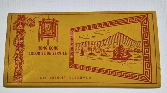
Perhaps the company has closed or changed names by now. Being unable to contact them, I’ve been unable to request their consent for posting their images. Please leave a message below if you are the copyright owner and object to the publication of these images.
The frame of each slide bears a reference code consisting of a two-letter prefix, either “XB”, “XC” or “XD”, followed by a number. Judging by their images, the “XB” prefix means views of Hong Kong Island, “XC” of Kowloon and “XD” of the New Territories. Another photo of the box mentioned above shows “XK” prefixed slides were also produced and their theme was “Landmarks”.

Knowing that “XB”, “XC”, “XD” and “XK” prefixes were produced, it’s reasonable to assume that prefixes “XA”, and “XE” to “XJ”, must also have existed and would have covered additional subjects. Prefixes beyond “XK”, e.g. “XL”, “XM”, etc., are also possibilities.
If prefixes “XB”, “XC”, “XD” and “XK” referred to slides of “Hong Kong Island”, “Kowloon”, “New Territories” and “Landmarks” respectively, then what did the “XA” prefix refer to? It’s noticeable that none of the 22 slides show arguably the two best known views of Hong Kong – a shot of the Peak Tram, and the view from Kowloon over Central to The Peak, so perhaps these and other iconic views were covered by the “XA” prefix.
The 22 slides consist of six “XB” slides, with various numbers between 3 and 17, nine “XC” slides between 2 and 20, and seven “XD” slides between 5 and 20. This suggests that 20 slides were produced for each prefix. If, as concluded earlier, at least eleven prefixes were used (“XA” to “XK”), each with 20 slides, that’s a minimum total of 220 slides sold by the “Hong Kong Color Slide Service”. That’s a lot of slides, so I’m a bit surprised that very few are for sale online.
I’d initially assumed that the 22 slides formed a set, but I’ve changed my mind for two reasons. Firstly, 22 is an unusual number. To my understanding, back in the 1980’s commercial slides normally came in boxes of 20 or clear plastic envelopes of 5. Secondly, all 20 slides in the same box would be of the same prefix. Unfortunately, the original wrapping of the 22 slides disappeared long ago so can’t be checked. How this mixture of “XB”, “XC” and “XD” slides came together remains a bit of a mystery.
Please feel free to add relevant comments and to correct the mistakes I’ve inevitably made.
Thank you to GW's mother for sharing her slides with us, and to GW for his research. If you can add information about any of these scenes, please click on the relevant photo and leave a comment on its page.
For more colour slides of old Hong Kong, please see these Gwulo videos:
Hong Kong Colour Slide Service Collection
Thank you 'gw' for posting this magnificent collection of your mum's slides. Your detailed descriptiions and analysis of each slide suggests you have spent many hours of painstaking research creating and presenting this Forum Topic. In my opinion this is of the highest quality of contributions we have read in recent months. A welcome relief from the reams of "copy and paste " extracts from Wikipedia pages or duplicatied and unresearched 'Facebook' images we have been subjected to, as of late. Thank you again and well done .
Slides
Thanks for sharing GW, there are some really nice images in that set. Great analysis as well. The squatter village reminds me a bit of the one on the side of Tai Hang Road/Braemar Hill where Lai Tak Tsuen is now. Similarly steep terrain...but who knows?
slides xc 12 and 15
xc12
The cross street that Ritz cinema and the restaurant across Nathan Rd was on is Shantung St., so the photographer had to be further south, likely near Dundas St.
The 4 circular signs on the restaurant was promoting red bean paste moon cakes, it had to be within a month before the mid-autumn festival. The signs would be taken down after the festival.
xc15
One of the neon signs on the right is for 雲來 restaurant, which was on Shanghai St.
XC 16
As noted, this view, and the wider one you have compared it to, were both taken from Lung Cheung Road - but specifically it is the view from what was later known as Lung Cheung Road Rest Garden (not to be confused with Lung Cheung Road Lookout which is further west). Not much of it remains now due to the widening of the road, but there are still some benches in the location. The central block of the army quarters should be Exeter House.
Thanks and Update
Thanks Chinarail and philk for your kind words and thanks to everyone else who posted comments both here and on the individual page for each slide (reached by clicking on each slide).
Yes, Chinarail you are correct in thinking that writing this article took many hours. That just goes to show the huge amount of time and effort David must have put into writing and producing all the interesting and informative articles and videos that he’s posted on “Page 1” of Gwulo over many years. And then there’s all the additional time, effort and money he puts into managing and operating Gwulo! So my thanks are due to David for all he does and for allowing this article on the Gwulo “front page”.
Now back to the slides. For those of you who can’t be bothered clicking your way through each pic, the feedback received so far for each one is summarized below.
XB 15, MTR
Moddsey noted that the MTR was officially opened by H.E. The Governor, Sir Murray MacLehose, at Shek Kip Mei Station on 30 September 1979, which was the day before the public opening.
XB 17, Squatter Areas
Truly fantastic work has been done here by cwyip911, Klaus, philk and Moddsey to nail down the location of this photo. Basically, cwyip911 recognised a random boulder in the photo as also appearing in another photo! Klaus and philk suggested the area, and Moddsey came up with its exact location ( https://gwulo.com/media/56096 ). If you haven’t yet done so, I’d encourage you to click on the slide photo and the above link to see how they did it. Brilliant.
XC 2, Night View Of Kowloon
Eurasian_david found three other photos that further narrow the year taken to 1973.
XC 10, Star Ferry
Thanks to Anthony for correcting my spelling.
XC 12, Street Scene At Night
Tkjho confirmed the location on Nathan Road and noted that an advertisement for “red bean paste moon cakes” means that the photo was taken around mid-autumn festival time.
XC 14, Jet Landing in Hong Kong Airport
Some of Gwulo’s airplane experts did sterling work here to identify the jet as a Swissair Convair CV990 Coronado and to date the pic from February 1962 to August 1964. Thanks to Moddsey, Jan Viebrock, Klaus, Moddsey and Thomas Chudalla. Please click on the slide photo to read their full comments.
XC15, Shanghai Street
Tngan, cwyip911 and tkjho read the signs and confirmed businesses in the foreground to have been located in Shanghai Street south of Soy Street, Mong Kok. Additionally, Cwyip911 noted that one of them, Kam Yuen Hong, had moved from Shanghai Street in 1965, meaning the photo was taken before then.
XC 16, Kai Tak District
Philk noted that this photo was taken from Lung Cheung Road Rest Garden over the roof of Exeter House in the foreground. Karl claimed that the airplane was a Civil Air Transport Convair CV 880. I don’t doubt it, but given the darkness of the image I’ve no idea how he did so.
XD 10, Watering Vegetables
Tngan noted that the farmer was using wooden watering cans, which would tend to date the photo to the 1960’s.