From grandaughter of Denis Ewart Donnelly. The family had a secomd home on Cheung Chao in the mid 20s
Date picture taken
1920s
Gallery
Shows place(s)
From grandaughter of Denis Ewart Donnelly. The family had a secomd home on Cheung Chao in the mid 20s
Comments
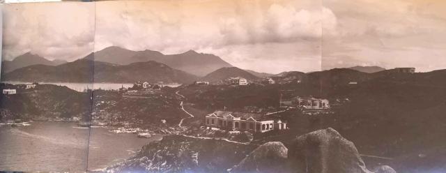
Hills of Nam Tam and Fa Peng area of Cheung chau
The background is the Lantau Island with the Chi Ma Wan Penisula appeared the landscape beyond the nearby shoreline which is along the water channel separating the main harbour of the Cheung Chau island.
Roughly the 2 houses on the far left are European Houses #24 and #25 and further towards east is another European House (# not sure) which is just next to the site of the Alliance Bible Seminary in the 1950s. You can see a narrow pathway coming off the ridge down to the rocky shore of the Nam Tam Wan. This pathway remains accessible between the crowded estates in the area. Further eastward appears the 2 larger house and building. They are being included in the future seminary campus too.
The 2 big bungalows should be on the Fa Peng area next to Nam Tam and the Rock close to the camera , as I speculate, is being named in recent decades, as the Rock of Emperor's Seal
There's also a small building
There's also a small building to the left of the path leading down to Nam Tam Wan. Could that be the Tin Hau temple?
The old Nam Tam Wan
That's probably right. In the 1950s the Tin Hau Temple was quite small, just at the foot of the pathway. Students from the nearby seminary came here too. A quiet spot for self-study!
It's still the same.... airwise.... today.
Tung
Correction from Tung
After careful inspection, I was wrong in locating the place where this picture was taken. It's impossible from the Rock of Emperor's Jade Seal, you can't see NamTam Wan from here.
The real location must be near the cliff end on the first headland east of Nam Tam Wan. Today there is a villa called Seascape Penisula. And there seems to be a different European House before. (not sure)
The first bungalow seems to be the Selesian ( ? Abbey ) and next one to the east seems to be on the same site of the Kwai Yuen Ching She. But quite unclear of what it was at that time. The Don Bosco Centre, would have been right behind the Selesians or hidden by the forest, was actually not even built yet, though the site had been levelled like a football field as indicated in the 1930s picture of Laura's Mysterious Rock on Cheung Chau.
Tung
Yes, I also think the
Yes, I also think the photographer was somewhere near the modern Seascape Peninsula.
More locations identified...
You can see the upper part of the northern hills of Cheung Chau. There was massive broken hills around north of Pak Tai Temple and was shown here as background of the 2 or 3 big houses on the ridge by Nam Tam Wan. This hilly range looks like a huge crocodile to me.
Over there, the tallest hill, which is further north of the broken hills crocodile, has the present-day aero-navigational station which is partly shadowed by the bungalow on the highland of Fa Peng near upper right of the picture.
I am quite amazed of the view given by this picture. It leads me to wonder if the photographer was standing on an unusually high spot. Was there a tall lighthouse before? ....We know the sea over there has reefs just below the sea level and is quite a risk for all big ships.
Tung
View from House #20
As Tung has said, I think this pic is taken from house #20. There is a building beyond House #22 which I cannot identify, and one between Houses #22 and #23.
Here is the full pic below, which is wide because it is 3 pics together. Houses 24, 25 and 19 may be seen here.
We are looking over the top of a rock, seen in this picture below, the tallest one on the right with a pointy top.