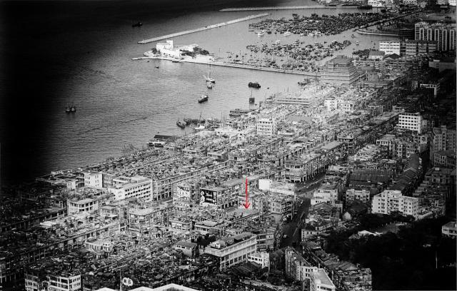
At the upper right corner of the photo I could see the Paterson Street development together with the Jardine Matheson warehouse at East Point. Victoria Park was also visible. I suggest the photo was taken around mid-1960s.
The Red Arrow appeared to be pointing to the present day location of the Hennessy Road Government Primary School. I‘ve looked up the school and was found it was rebuilt in 1962 to its current state. The new building was inaugurated in September 1963. Is the Red Arrow meant for the Fire Station? If so, it doesn't seem to add up to me.
On the other hand the Canal Road Fire Station is visible by the right. If you zoom in to the most and locate the JM & Co. buildings, you should be able to locate it if you scroll down a bit, about six to eight clicks on the down arrow of Zoomify.
I have done a little bit research about the few visible blocks of Paterson Street Residential blocks just behind Jardine Matheson Warehouse. The three visible and completed blocks are from right to left. likely #53, 55 & 57of Paterson Street. Residents started moving in in 1958 for #53 & 55. The incompleted block was likely #59. As for #57 residents started moving-in in Sept 1961. For the incomplete #59, residents started moving-in in November 1961. Those approximate move-in dates were obtained from CentaData.
In this respect, with the incomplete #59 Paterson Street, the photo was likely taken in late 1960 or early 1961.
For those not familiar with the area, the mentioned #59 Paterson Street is the location of present day Town Gas Mia Cucina Showroom and Restaurant (Towngas Avanue).
There are actually many landmarks shown in this photo. I will try to name a few:
1. Jardine Matheson Godowns at Eastpoint. Its present day location housed the Excelsior Hotel, World Trade Centre, and two other residential Towers righ at East Point Road. Actually the Paterson Street redevelopment stood on JM's former factory site too, as far away as Sugar Street.
2. Paterson Street Residential Development;
3. Wanchai Pier just off Stewart Road;
4. Wanchai Police Station at Gloucester road, which was the water front at that period;
5. Police Quarters between Lockhart Road and Jaffe Road, just opposite the back door of Wanchai Police Station;
6. Wanchai Fire Station at Hennessy & Canel;
7. Rutungee Sanitorium on Hospital Hill;
8. Orient Cinema. Actually it is not visible. But the space it occupied on Fleming Road is;
9. Caltax Petrolium Station at Hennesy & Johnston;
10. The stretch of shophouse where the present day Fung Leung Kee Watches is located. The ground floor of this whole block used to be a Chinese Restaurant called Ying King (英京酒家) which my family frequently went there when I was a kit. That would be the NW corner of Fleming & Johnston.
11. Hennessy Road Wet Market. Again it is not actually visible, but you could locate it if you draw a straight line from Wanchai Police Station straight through the Police Quarters towards Hennessy Road. It's also just opposite the Hennessy Road Government Primary School, as marked by the red arrow;
12. Victoria Park is on the top of the photo, right at the edge;
Thanks Thomas, that's a good list. I'm just finishing for today, but in the next couple of days I'll add any Places we have from that list to the Places Shown.
I believe there should be a few more cinemas. I'd better check the period before trying to point them out. What I have in mind are, New York Theatre (at Hennessy & Percival), Cathay Theatre (at Wanchai Road and Cross Lane), National Theatre (at Lockhart & Marsh). Oh, the previously mentioned Cinema should have been Oriental Theatre.
Could not find much information about those old theatres. But found the New York already exist in the 1950's. Confirmed it is partially in this photo. Just locate the Canal Road Fire Station and move towards the JM & Co Godowns. It should be the big building with very few windows.
I wonder how could I miss that. The business sign of the Cathay Theatre in Chinese is clearly visible if you zoom in to the extreme. The words 國泰 are clearly visible. That would be the tallest building in white/light grey, just behind Hospital Hill.
While locating Cathay Theatre I realized a building at Johnston/Fleming/Wanchai is marked Salvation Army in Chinese. Would that be the same old building that used to be a Police Station? I believe there is another thread about this building. Maybe some tags to correlate these two is justified.
Confirmed. At Lockhart & Marsh there is also a building with slaunted roof. That was was a light grey one. That's the National Theatre, at the NW corner. I mistook the back alley between the shop houses of Hennessy Road and Lockhart Road as Lockhart Road. That was why it did not add up earlier. The back alleys of the area still exist. Sadly speaking, they are what's left of the Shop houses of the area, save the very few remaining shop houses.
I think WRX20K is referring to the location of the temporary Eastern Fire Station prior to the completion of the current Wanchai Fire Station in 1941. See here As the article is from 1933, I think the location fits in well with the timeline of the temporary Eastern Fire Station.
Just wonder why Mr. Harrison Forman did not take the photo of this special building (Wan Chai Fire Station) but just took the photos of the building next to it and back of it.
Comments
Re: Wanchai Fire Station
Hi there,
At the upper right corner of the photo I could see the Paterson Street development together with the Jardine Matheson warehouse at East Point. Victoria Park was also visible. I suggest the photo was taken around mid-1960s.
The Red Arrow appeared to be pointing to the present day location of the Hennessy Road Government Primary School. I‘ve looked up the school and was found it was rebuilt in 1962 to its current state. The new building was inaugurated in September 1963. Is the Red Arrow meant for the Fire Station? If so, it doesn't seem to add up to me.
On the other hand the Canal Road Fire Station is visible by the right. If you zoom in to the most and locate the JM & Co. buildings, you should be able to locate it if you scroll down a bit, about six to eight clicks on the down arrow of Zoomify.
My 2 cents,
T
Re: Wanchai Fire Station
Thanks to WRX20K for uploading the photo. It's a good view of the area.
I agree with Thomas that the arrow points to the school, though I think it is the older pre-1963 version, as it is only two storeys high.
Regards, David
Re: Dating the photo
Hi David,
I have done a little bit research about the few visible blocks of Paterson Street Residential blocks just behind Jardine Matheson Warehouse. The three visible and completed blocks are from right to left. likely #53, 55 & 57of Paterson Street. Residents started moving in in 1958 for #53 & 55. The incompleted block was likely #59. As for #57 residents started moving-in in Sept 1961. For the incomplete #59, residents started moving-in in November 1961. Those approximate move-in dates were obtained from CentaData.
In this respect, with the incomplete #59 Paterson Street, the photo was likely taken in late 1960 or early 1961.
Best Regards,
T
Thanks Thomas, I'll set the
Thanks Thomas, I'll set the date to Jan 1961.
Regards, David
Re: Unfinished block, #59 Paterson Street in the photo
Hi there,
For those not familiar with the area, the mentioned #59 Paterson Street is the location of present day Town Gas Mia Cucina Showroom and Restaurant (Towngas Avanue).
Best Regards,
T
Places shown in this picture
Hi there,
There are actually many landmarks shown in this photo. I will try to name a few:
1. Jardine Matheson Godowns at Eastpoint. Its present day location housed the Excelsior Hotel, World Trade Centre, and two other residential Towers righ at East Point Road. Actually the Paterson Street redevelopment stood on JM's former factory site too, as far away as Sugar Street.
2. Paterson Street Residential Development;
3. Wanchai Pier just off Stewart Road;
4. Wanchai Police Station at Gloucester road, which was the water front at that period;
5. Police Quarters between Lockhart Road and Jaffe Road, just opposite the back door of Wanchai Police Station;
6. Wanchai Fire Station at Hennessy & Canel;
7. Rutungee Sanitorium on Hospital Hill;
8. Orient Cinema. Actually it is not visible. But the space it occupied on Fleming Road is;
9. Caltax Petrolium Station at Hennesy & Johnston;
10. The stretch of shophouse where the present day Fung Leung Kee Watches is located. The ground floor of this whole block used to be a Chinese Restaurant called Ying King (英京酒家) which my family frequently went there when I was a kit. That would be the NW corner of Fleming & Johnston.
11. Hennessy Road Wet Market. Again it is not actually visible, but you could locate it if you draw a straight line from Wanchai Police Station straight through the Police Quarters towards Hennessy Road. It's also just opposite the Hennessy Road Government Primary School, as marked by the red arrow;
12. Victoria Park is on the top of the photo, right at the edge;
Best Regards,
T
Thanks Thomas, that's a good
Thanks Thomas, that's a good list. I'm just finishing for today, but in the next couple of days I'll add any Places we have from that list to the Places Shown.
Regards, David
Re: Places shown in the photo
Hi David,
I believe there should be a few more cinemas. I'd better check the period before trying to point them out. What I have in mind are, New York Theatre (at Hennessy & Percival), Cathay Theatre (at Wanchai Road and Cross Lane), National Theatre (at Lockhart & Marsh). Oh, the previously mentioned Cinema should have been Oriental Theatre.
Best Regards,
T
Re: New York Theatre
Hi there,
Could not find much information about those old theatres. But found the New York already exist in the 1950's. Confirmed it is partially in this photo. Just locate the Canal Road Fire Station and move towards the JM & Co Godowns. It should be the big building with very few windows.
Best Regards,
T
Re: Cathay Theatre
Hi there,
I wonder how could I miss that. The business sign of the Cathay Theatre in Chinese is clearly visible if you zoom in to the extreme. The words 國泰 are clearly visible. That would be the tallest building in white/light grey, just behind Hospital Hill.
Best Regards,
T
Re: Salvation Army
Hi there,
While locating Cathay Theatre I realized a building at Johnston/Fleming/Wanchai is marked Salvation Army in Chinese. Would that be the same old building that used to be a Police Station? I believe there is another thread about this building. Maybe some tags to correlate these two is justified.
Best Regards,
T
Re: Oriental Theatre
Hi There,
Again, how could I miss that. Some correction is in order. The slaunted roof in black tiles of the Oriental Theatre is in fact visible in the photo.
Best Regards,
T
Re: National Theatre
Hi there,
Confirmed. At Lockhart & Marsh there is also a building with slaunted roof. That was was a light grey one. That's the National Theatre, at the NW corner. I mistook the back alley between the shop houses of Hennessy Road and Lockhart Road as Lockhart Road. That was why it did not add up earlier. The back alleys of the area still exist. Sadly speaking, they are what's left of the Shop houses of the area, save the very few remaining shop houses.
Best Regards,
T
Hi Thomas, thanks for the
Hi Thomas, thanks for the updates.
I've added Places for those new ones, except: I've left New York off as it isn't clear to see, and we don't have a Place for the National Theatre yet.
Regards, David
Wanchai Fire Station
Hello, an old news to prove the location.
Re: Wanchai Fire Station
Good find.
I think WRX20K is referring to the location of the temporary Eastern Fire Station prior to the completion of the current Wanchai Fire Station in 1941. See here As the article is from 1933, I think the location fits in well with the timeline of the temporary Eastern Fire Station.
Wan Chai fire Station
Just wonder why Mr. Harrison Forman did not take the photo of this special building (Wan Chai Fire Station) but just took the photos of the building next to it and back of it.
May be he had taken but the film was ruined.
photo
photo
Photo
Hi Here are the photos you uploaded (we've already got copies of both photos here on Gwulo, so I've deleted the duplicates):
Regards, David
Wan Chai Fire Station
An aerial view photo can see the top of the building.
http://i61.photobucket.com/albums/h68/sammy097/Wan%20Chai%20Fire%20Stat…