Update 2023.04.08
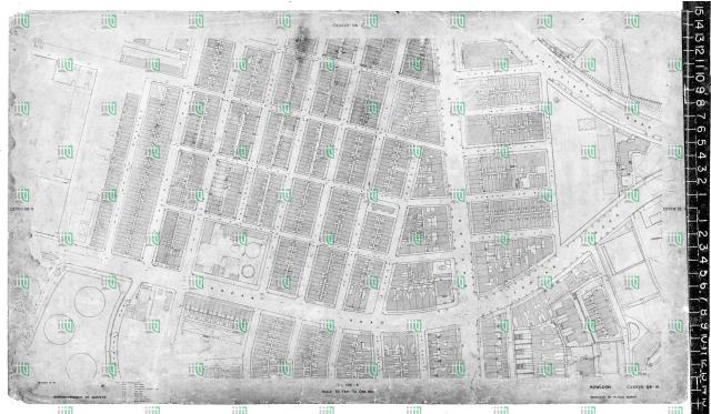
Shows the area north of Jordan Road near the junction with Nathan Road. The map is attributed to 1922 on hkms2.0.
Likely not the situation of 1922 but probably the planned reconstruction of the junction as announced in October 1923 (call for Tender for improvements to the junction of Nathan and Gascoigne Roads, Kowloon). So the map possibly shows the situation in 1927-1930.
The building shown between Pak Hoi and Kansu Streets should be the second generation Po Hing Theatre.
Date picture taken
1928 (year is approximate)
Gallery
Comments
location of theater
Your map shows that the theater was bordering Pak Hoi street but the Nathan road-Gascoigne road junction is not shown.
The 1920 and 1924 maps seem to show the theater is rather near the Nathan road-Gascoigne road junction.
1920 map:
1924 map:
Po Hing Theatre
The Po Hing Theatre should be the building shown on the map below:
According to hkms 2.0 it is from 1922. Likely not the situation of 1922 but probably the planned reconstruction of the junction as announced in October 1923 (call for Tender for improvements to the junction of Nathan and Gascoigne Roads, Kowloon).
The building shown between Pak Hoi and Kansu Streets should be the Po Hing Theatre, although it's orientation is not correct.
Re: Po Hing Theatre update
The date of the map is likely 1927-1930 rather than 1922. So we see second generation Po Hing Theatre, see comments here.
Thank you simtang for the correction.