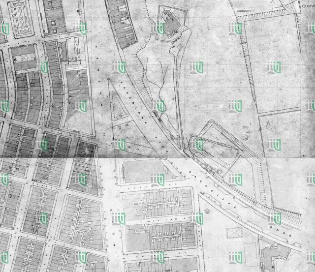
Map of the junction of Nathan and Gascoigne Roads. The map is attributed to 1922 on hkms2.0.
Likely not the situation of 1922 but probably the planned reconstruction of the junction as announced in October 1923 (call for Tender for improvements to the junction of Nathan and Gascoigne Roads, Kowloon). So the map possibly shows the situation in 1925-1930.
The building shown between Pak Hoi and Kansu Streets should be the second generation Po Hing Theatre.
Date picture taken
1928 (year is approximate)
Gallery
Shows place(s)
Comments
Po Hing Theatre
Hi Klaus,
The outline on the map looks like that of the larger, second generation theatre: https://gwulo.com/po-hing-theatre-2
That will mean the map is several years older than 1922.
Regards, David
Re: Po Hing Theatre
Hi David,
yes, I didn't think that the building shown is rather second than first generation theatre, although I wrote that the map shows the situation later than 1922. I will correct my entries.
What puzzles me is that fact that this map on hkms2.0 is attributed to 1922. I now see that this is definitely incorrect if you compare the 1924 aerial photo of this area:
In 1924, Gascoigne Road is still "crooked". Unfortunately, I couldn't find any entry in the PWR's from 1924 to 1931 about the reconstruction. So I don't know from which year this map really is. Haven't checked other areas, but the situation here looks as if it is rather 1927-1930 than 1922.
"1922" map
I've had trouble with that map series before - if you look at https://gwulo.com/media/43227, the map is dated 1922 but it shows the causeway that was built in 1934.
I'm not sure if the whole series has been given the wrong date, or if a few newer sheets have got mixed in with the 1922 sheets.