This should be titled below Hospital Road rather than Caine; showing the top of the Tai Ping Shan area. the track on the right of the picture is Rutter Lane with Pound lane running mid right to left down the hill in front of the row of houses. The building behind was the police station no 8(?) second generation before it moved to High street.
This photo was taken from the platform of this building after it was demolished in the 1920’s
This platform that the building was built on collapsed during heavy rains in the 17th July 1925 killing 75 people living on Po Hing Fong including a member of Legco Chau Siu-ki..
which if correct means this photo is later, due to the newer buildings, however there are no signs of the clearence of the neighbourhood shown here that happened in 1898
Comments
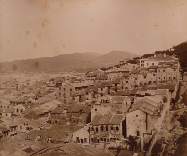
Below Hospital Road
This should be titled below Hospital Road rather than Caine; showing the top of the Tai Ping Shan area. the track on the right of the picture is Rutter Lane with Pound lane running mid right to left down the hill in front of the row of houses. The building behind was the police station no 8(?) second generation before it moved to High street.
This photo was taken from the platform of this building after it was demolished in the 1920’s
http://gwulo.com/atom/19497
This platform that the building was built on collapsed during heavy rains in the 17th July 1925 killing 75 people living on Po Hing Fong including a member of Legco Chau Siu-ki..
Taken from the same vantage point:
http://gwulo.com/atom/19845
http://gwulo.com/atom/19485 (This looks like it could be from the same series of photos
http://gwulo.com/atom/13012
The first photo in the SCMP article listed below is dated 1894
http://www.scmp.com/magazines/post-magazine/article/1535499/when-death-…
which if correct means this photo is later, due to the newer buildings, however there are no signs of the clearence of the neighbourhood shown here that happened in 1898
https://www.flickr.com/photos/89154377@N02/9781523821/
Similar views
Please add these places
Top Right of Photo is No. 8 Police Station (2nd Generation) http://gwulo.com/node/20883
Building half hidden behind police station is this one:
http://gwulo.com/node/32523
Large building with triangular roof to left is Dinder
http://gwulo.com/node/5010
Middle Left of the photo can be seen No.8 Police Station (1st Generation) http://gwulo.com/node/32521
Just to the right of seen No.8 Police Station (1st Generation) is the London Mission Chapel and Dispensary
http://gwulo.com/node/32519
Tung Hing Theatre is at the bottom left corner of photo.
http://gwulo.com/node/32520