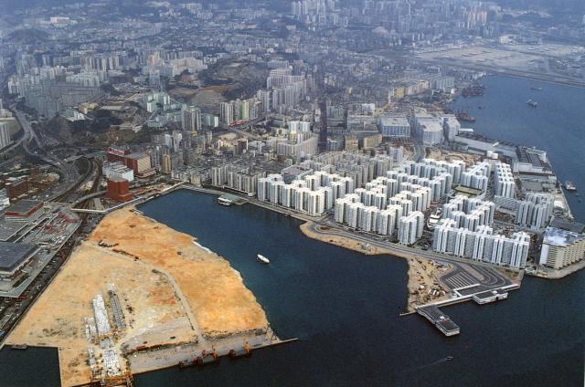
This image shows three of the ferry pier locations as reclamation progressed. The second? location is a floating pier next the roadside and the older estate. A Star Ferry is heading towards it. Of interest is that the substantial newly built permanent pier near the railway station seen in earlier images has already disappeared. A planning problem? Related images
Date picture taken
15 Jun 1988
Gallery
Shows place(s)
Comments
Re: Hung Hom Peninsula and Piers
Hi there,
In this photo the bus terminus had not been moved to the new pier yet and yet the HYF piers were already completed. And yet there were no signs they had been inaugurated yet.
I believe it is likely that the make-shift pier Hung Hom Bay Centre was for HYF ferries for both Wanchi and North routes. Star Ferry (to and from Central) was still using the pier in their previosu location. In the photo there seemed to be a structure printed in dark green, between the two foot bridges. I think the Star Ferry in the photo was heading to there instead.
Could someone confirm?
Best Regards,
T
Similar image
Here is a similar image dated to 1989. Obviously, this was taken earlier as the one above. Suggest to check which date is correct.
this should be 1991
I lived in Whampoa from 1991 until 1994 and, as far as I remember, this should be late 1991.
ferry pier
The main image should be from 1991 at the earliest when the Hung Hom pier was moved to its current site on the newly reclaimed land.
Wiki states this pier was built in the 1965 but I think it is referring to the current First ferry pier and not the Star ferry one. I can't find any 60's era images of Hung Hom showing the latter.
Also I note that the pier shown in this image is a slightly different design to the current one at Hung Hom (current one is shorter with fewer apertures at the side and the lower 'wings' near to the land entrance are covered by the roof on the current one). So I don't think the current pier is the same one seen on these photos - unless it underwent significant changes.
So if the current Frst ferry pier is the 1965 built one, which pier is identified by this node: https://gwulo.com/node/35899?
I can see an older ferry pier
I can see an older ferry pier marked on the 1956 map at the end off the end of Gillies Ave at Winslow Street: https://gwulo.com/map-of-places#17/22.30626/114.18349/Map_by_ESRI-1956_Kowloon-Markers/100
Klaus and Thomas, does that pier match up with any of your markers? If not I'll make a new place for it.
Regards, David
Hung Hom Piers
These ferry piers seem to be a bit tricky.
David, there was a pier at the end of Gillies Ave, but this is not identical with the two ones shown below.
These two are
Former Hung Hom Ferry Pier (1979) for Hung Hom/North Point service [????- ] and
Former Hung Hom Ferry Pier (1979) for Hung Hom/Central service [????- ].
They are visible on an aerial photo from 1963 shown at hkmaps.hk.
Also, the OFFICIAL REPORT OF PROCEEDINGS, Meeting of 21st August 1963 states:
.......
it is now desired that the Schedule to the Ordinance be varied to provide for the operation by the Company [HYF] of three ferry services across the harbour, namely, the services between Kowloon City Ferry Pier and North Point Ferry Pier (east berth), between Hung Horn Reclamation (berth No. 1) and North Point Ferry Pier (west berth) and between Tonnochy Road Ferry Pier and Hung Horn Reclamation (berth No. 2);
......
Kowloon City Pier
Eastern side of Gillies Avenue to south-western boundary of Kai Tak Airport.
Hung Hom Reclamation (Berth No. 1 and Berth No. 2).
The southern extremity of Whampoa Street and the east boundary of the property known as "Holts' Wharf".
The Whampoa Street one matches quite good with the position of the marker, the one with Holt's Wharf surprises me a bit.
The Gillies Ave pier appears first in the 1941 map on hkmaps.hk as "Proposed Vehicles Ferry Pier", than on the 1945.3 and the 1947 maps, resp.
After about 1955, it doesn't appear on the maps (due to reclamation in this area), but in 1963 it seems to exist still.
Anyway, it's a new place.
Regards, Klaus
Gillies Ave pier
I believe - with a bit of imagination - the pier is visible on this 1946 aerial photo (cropped from: https://gwulo.com/atom/30309)
re: Gillies Ave pier
Thanks Klaus. I've made a page for the old pier at https://gwulo.com/node/47421