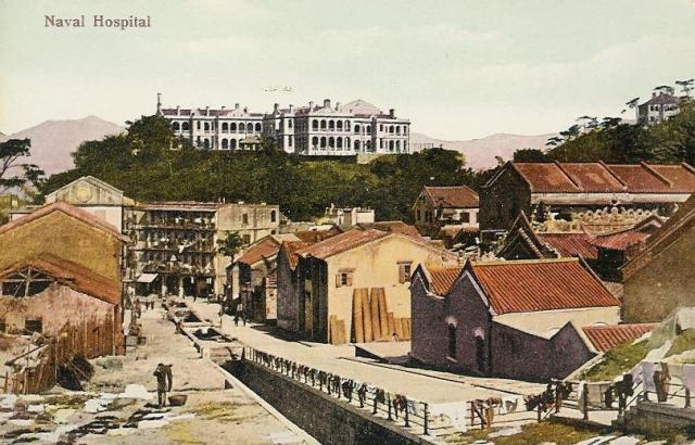
How did Mount Parish get its name? Originally I thought it was from some connection with the Methodist church on the corner of Queen's Rd E and Kennedy Road. But it turned out the church came after the Parish, not the other way around.
This page has the full story, together with an early sketch of the area. The author, Peter Davis, writes that Hong Kong's first land-based Royal Naval Hospital opened when the navy bought the "Seaman's Hospital which had been first opened in Wan Chai in 1843 [...]. This water-front hospital, which [...] had flourished for many years, was by the 1870s running at a loss. A letter from Vice-Admiral Shadwell, the Commander-in-Chief on the China Station, reveals that William Loney, as chief Medical Officer on the station from October 1872 to January 1875, played a large part in the successful move ashore. [...] The hills on which the hospital - and the later Infectious Diseases Hospital - were built, were given the names Mount Shadwell and Mount Parish respectively (Commodore John E. Parish was the "Naval Officer Commanding" in Hong Kong between 1873 and 1876)."
So, as with the English names of many of Hong Kong's landmarks, 'Parish' was the name of a British man in Hong Kong at that time. As for the Methodist church, that originally acted as a church for the seamen in the area.
Now, what about that comment 'This water-front hospital' above? Yes, in those days the hospital was on a hillside overlooking the sea. Here's the map in 1863, you should just about be able to make out the words 'Hospital Hill' in the middle. At that time it would still have been the Seaman's hospital overlooking the shoreline - the present-day Johnston Road. Queen's Rd East is shown on the map south of the hospital, then south of that lies the grid of roads around Stone Nullah Lane.
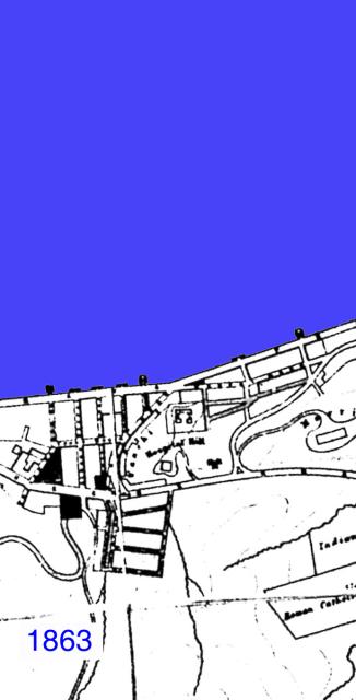
More info about this picture here.
Moving forward to 1889, the hospital is still marked the 'Seaman's Hospital', though it should already have been the Royal Naval Hospital according to the note above. The route of Kennedy Road is there, though this last section of it that joins Queen's Rd E. was originally called Albany Lane.
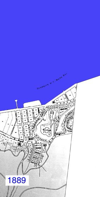
More info about this picture here.
In 1931, more changes. 'Mount Parish' appears at last, and is the site of the Infectious Diseases Hospital. Morrison Hill to the North East was still a hill, though the map says it is 'in course of demolition', as it was used as landfill for the new reclamation up to Gloucester Road, also clearly shown on the map.
The RN Hospital has changed shape from a cross to more of a 'T' shape, so it looks as though three of the four original wings had been extended. (The sketch on Davis's site shows no room for extension - either they had to enlarge the hill or more likely there was a certain amount of artistic licence taken when that sketch was made.)
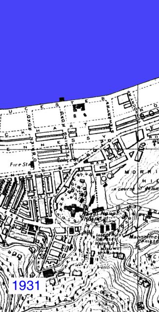
More info about this picture here.
Comments
In the map of 1946 the new reclamation now shows it is heavily built-up. Just to the South West of the RN Hospital you can see the Wanchai market.
More info about this picture here.
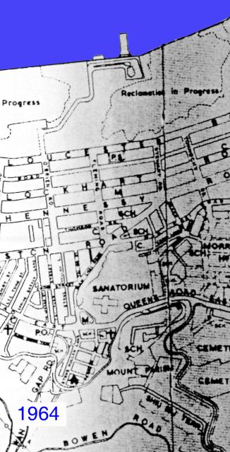
In 1964, yet another round of reclamation is underway. The Infectious Diseases Hospital has been demolished, and Mount Parish is now the site of the Wah Yan College, which opened in 1955 and is still there today. The outline of the RN Hospital is still there - I wonder when it was demolished?
More info about this picture here.
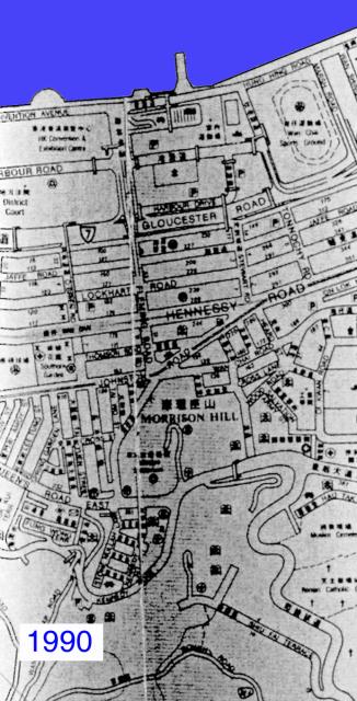
By 1990, everything is pretty much the same as it is today. Kennedy Road has been straightened out, the RN Hospital has been replaced by the Ruttonjee, and the name 'Mount Parish' has dropped off the map.
More info about this picture here.
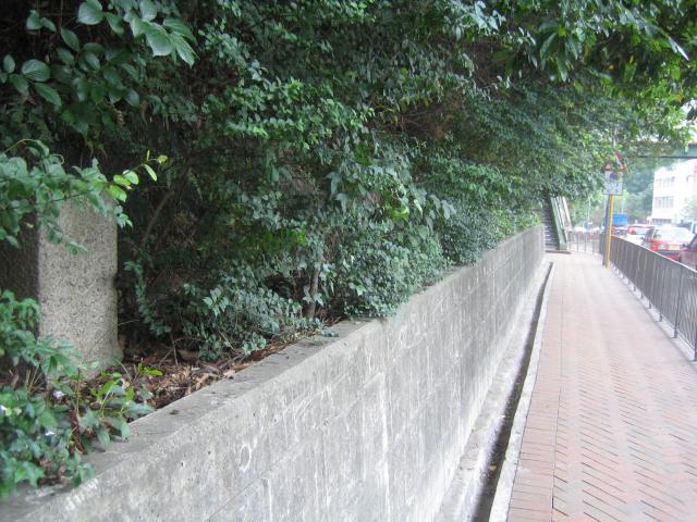
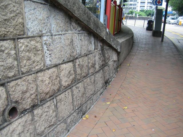
I took another walk around the area, to see what I'd missed the first time. Walking along Queen's Rd East from the junction with Stubbs Road, there is this granite pillar on bank to your left.
More info about this picture here.
More info about this picture here.
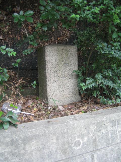
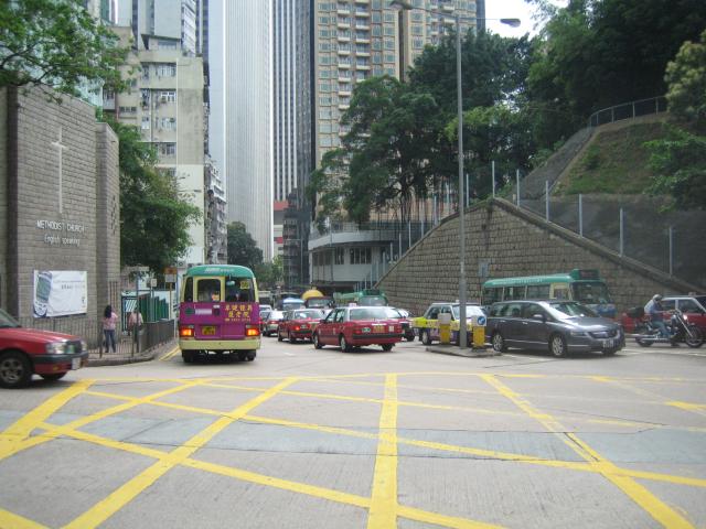
Any idea what it represents? It is inscribed with a '7' on top, an anchor in the middle, and '1905' underneath. Next comes the junction with Kennedy Road, with the Methodist church on the left, Wanchai market dead ahead in the centre, and the hill on the right where the RN Hospital stood.
More info about this picture here.
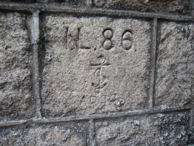
Low down in the retaining wall of that hill is another inscribed stone. This one says 'I L 86', then an anchor, then 'AD 33'. The Wanchai market was built in the early 1930s, so I guess this wall was built at the same time. (Does anyone know what the 'I.L.' stands for? I have seen those initials on other stones around Hong Kong)
More info about this picture here.
More info about this picture here.
Here is the entrance to the Wanchai Market building, which unfortunately is scheduled for demolition.
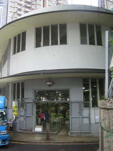
More info about this picture here.
You can still get up on the roof, so here's the view back towards the junction of Kennedy Road and Queen's Rd E, with a view of Wah Yan college behind the trees. I guess this roof is where the British troops we mentioned in the last piece were positioned with their 18-pounder?
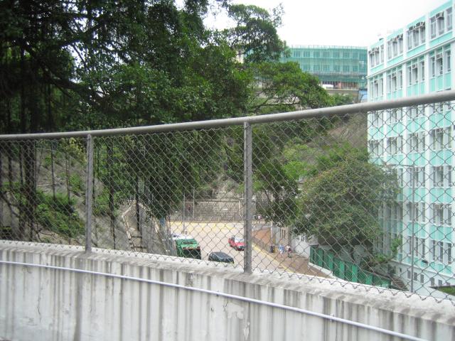
More info about this picture here.
It's hard to see why they'd have chosen this place as it seems to have a very limited view. But of course the surrounding buildings were so much lower then, they'd probably have had a view of the whole of Mount Parish, and much of Kennedy Road too.
To see just how different it would have been then, take a look at this photo of the area in the late 1930s. Walking down the staircase from the market roof I saw the familiar shape of the doorway to an air-raid tunnel - there must be another network under Hospital hill.
More info about this picture here.
Looking back along the retaining wall and there's another entrance a little further along.
More info about this picture here.
Just across Queens Rd E, opposite the market is Stone Nullah Lane, a road that was visible on the 1863 map. Here on the corner of that Lane and King Sing St is a building that's hard to miss.
More info about this picture here.
It's a wonder that it has managed to last this long; it would certainly have been here before any of those air raid tunnels were built. There can't be many buildings in Hong Kong that still have wooden stairs?
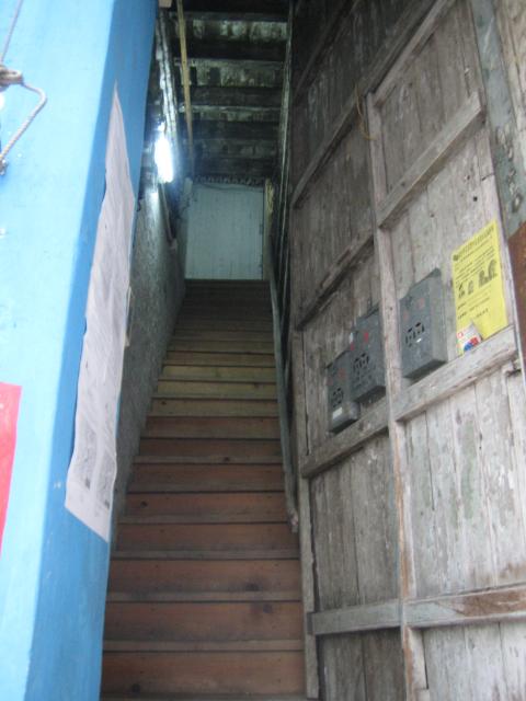
More info about this picture here.
I wanted to take a look at this road to compare it with this excellent picture of Stone Nullah Lane that reader Moddsey had kindly sent in (thanks also to him for several other pieces of information I've used here).
More info about this picture here.
Comments
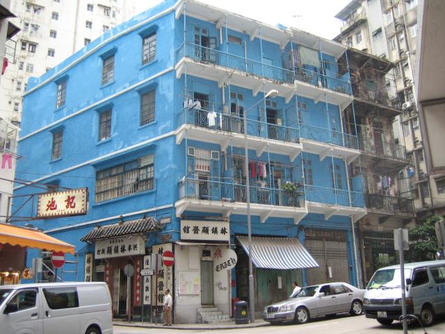
The three stories house that can be seen at the end of the nullah is what we now call the Blue House. It has strong links to the martial art Hung Kuen. I've written an article about the history of the Blue House, especially in regards to the martiart practiced there. It can be read online here:
http://naamkyun.com/2012/12/the-blue-house-a-piece-of-hung-kyun-history/
Hope you enjoy and find it usefull.
Hi, I don't think that's the Blue House, although it is a very similar style of building. If you look at the Blue House, it's set parallel to the nullah, whereas the four-storey building in this photo is at an angle.
I believe that the Blue house was built after this photo was taken.
Thanks for the extra information about the Blue House's history, I've added to the main page for the building:
Regards, David
The naval hospital dominates the area, and is in its extended 'T' shape, not the earlier cross shape. The stone-lined nullah that gave the lane its name is also clear to see. The blue building photographed above had not yet been built, though a very similar building stands at the bottom of the lane.
On the right of the picture is the Pak Tai Temple, looking much as it does today. In fact if you go back to the older picture on Davis's site, you'll see the temple's roof also appears there in the bottom right corner. There are many more trees along the lane now, which make it difficult to get exactly the same view. Still, the lines of the temple roof today are clearly the same as in the earlier pictures:
More info about this picture here.
If you have any more information about the area's history, we'd love to hear from you.
References:
- PRO catalogue: http://www.grs.gov.hk/ws/english/es_online_cata.htm
- Maps: The easiest way to look at them is to see the 'Mapping Hong Kong' book in the map section of Central Library. They also have larger scale copies of the individual maps available.
Comments
I mentioned your comment to a friend who said he understood I.L. stood for 'Inland Lot'. If I search the web I can find a lot of mentions of inland lot but no island lot, so I think he is right. I see there are also Marine Lots. I guess the distinction was important when being on the shoreline meant you could have your own wharf.
MrB
Reader moddsey has some more info:
I.L. stands for Inland Lot. Over in Kowloon it is K.I.L. for Kowloon Inland Lot and for North of Boundary Street it is N.K.I.L. for New Kowloon Inland Lot.
If you see M.L. it stands for Marine Lot.
These days you will only see these demarcations and lot numbers on old buildings. By the way, Inland Lot 1 is now where the Excelsior Hotel is situated. It was the first parcel of land purchased by Jardine Matheson in the first public auction in the 1840s.
From an old version of their website:
The history of this Church began in 1885 when an application for a Wesleyan Chapel for sailors and soldiers were submitted.
The chapel was officially opened on Sunday, May 20th 1893 - the beginning of the English Methodist Church, also known as the Garrison Church, or the Military Chapel.
MrB
Moddsey again: visit http://hkclweb.hkpl.gov.hk/hkclr2/internet/eng/html/frm-bas_srch.html, check the 'Photo' box, type
wanchai race
in the text box, and click search to find the photo.
You can find many other interesting photographs through that search page.
MrB
Reader Moddsey points us to more info about the temple and other Wanchai Landmarks: http://www.gohk.gov.hk/text/eng/welcome/wc_spots.html
MrB
Reader Moddsey writes in with some more history of the blue building photographed above:
- History of the building, and government's plans for its future. More ...
- Another history. (See bottom of page 5)
MrB
Great stories on the Blue House from Moddsey!
But I had trouble assimilating the second one, because I was too busy hyperventilating. If you look at the bottom right hand corner of the page just above the Blue House story, you find an advertisement for a townhouse that's currently for sale. Price: $110,000,000. Sheesh.
from Moddsey:
Interesting comment below about the removal of night soil from the Blue House!!
http://www.lcsd.gov.hk/CE/Museum/Monument/yfoh/en/bluehouse.php
Photos of the Blue and Yellow Houses
MrB
I like your articles very much. I used to live in Shiu Fai Terrace just up from Mt Parish and am now living in Kennedy Road near the Star Street Tunnels. In fact I walk past them every day to go to work.
To respond to your question- I.L. probably means "Inland Lot". It's a codification system used by the Hong Kong Lands Department to identify parcels of land in Hong Kong.
Keep up the good work!
Adrian
well researched local history study.
I have a place on Kennedy Street, and find wondering around that area very interesting.
Living in Macau now, where there are whole quarters similar to the 'Blue House' still in living use and occupation...a hard life for teh occupants despite the historical interest.
Suggest you wander up to the top of Ship Street further along, and see some still intact stone walls, tunnels, decaying mansions etc...May not be around too much longer as the redevelopment moves through the area.
The mansion house if it is still there was the focus of a bizarre haunting incident in 2003, when some kids broke in late one night, and were hospitalised by what they saw.
Its strangely spooky alright...would like to know more about the history of that property if anyone knows anything.
Julian
Julian,
Glad you enjoyed this. There's also a little bit of info on Ship Street in our post about Star Street.
I'm not sure which mansion you mean though - do you have a building number or name (the centamap website can be helpful if you need a map to check.)
...a hard life for teh occupants despite the historical interest.
Yes, I remember reading about a walled town in China which has been made a cultural site. I think it was in a poor area so that it had been left almost unchanged, ie a great tourist spot. But the residents wanted to knock down their old houses and build new ones that would be more comfortable, with proper plumbing!
Regards, MrB
I think the house that Julian refers to is called Nam Koo Terrace, situated up a flight of stairs at 55 Ship Street. Long abandoned and slowly decaying, it was once surrounded by decrepit tenement blocks (also with wooden staircases)but these have been bought up and demolished to make way for Sir Gordon Wu's Mega Hotel project.
I am also trying to track down info on an old mansion that used to be on Conduit road near the university. I managed to sneak into it in the late 1980's before it was demolished. It was at number 55.
I also have a few photos of the above, as well as other relics of the past if you are interested.
Thanks for the extra info - I've walked up Ship Street before, but I guess I've not gone far enough up to see this building. A Google on 'Nam Koo Terrace' turned up several related pages, including this one that has some pictures.
If you have any pictures of how it looked when it was still lived in, we'd be very happy to link to them / or post them up here as you prefer.
Regards, MrB
Many thanks for the replies all.
You might find the St.James Settlement website interesting - some good photos of the area of Stone Nullah Lane, Pak tai Temple, and Kennedy Road there frm 1940s and before.
There is one view of Stone Nullah Lane pre 1940 that seems very similar to the old photo further up the thread.
Yes some good shots of Nam Koo Terrace - again thanks for the links.
HK Library - multimedia website also has some good historical views of the Wanchai district.
Finally a wander around the Happy Valley Cemetaries, gives you a strong impression of those early years in the district, from the sea-captains, soldiers, firemen, cholera victims and other characters, interred there.
Brave the mosquitoes and see if you can reach the higher terraces adjoining Stubbs Road. Fascinating if a little morbid...
Julian
Hello, I have read your articles and I like very much.
I am also interest in old buildings in HK. Last month I visit Ruttonjee Hospital & Wan Chai Market, I found two old building elements placed on the side of the access road leading from Wan Chai Market to Ruttonjee Hospital.
I wounder these two old building elements are the remains of Old Ruttonjee Hospital or Naval Hospital? I have taken the photos and put in the following links.


Regard Bush HUNG
We lived in an apartment 1A Kotewall Road about 7 years back. The building is still there. It's only 3 stories and it still has wooden steps. Our flat on the 2nd floor still had the original tiles in the dining room as did the floor below us. Just before we left HK they were "renovating" downstairs, so i'm pretty sure that disappeared. Don't know what happened to ours. We also had the original high ceilings and wooden door and window frames. Might pop over and see if they've kept it all one day. I think the building was pre-war.
>Any idea what it represents? It is inscribed with a '7' on top, an
>anchor in the middle, and '1905' underneath.
I have seen another similar stone around that location. It was inscribed with a '8' above an anchor. The lower portion was burried in soil and fallen leaves. I guess there should be some other stones with different numbers around that place.
Boundary stones for land lots are not uncommon, in particular those inscribed only with "I.L." followed by some digits which represents the number of the "inland lot". It seems that stones with "anchor" are relatively rare. The symbol should have a special meaning, prehaps it was associated with the navy. I totally have no idea on "AD 33". In a visit to that place and on the same retaining wall, I've seen another stone inscribed with "I.L.86.", an anchor, then "AD 13" (actually the last figure was not very clearly seen and it just seemed to be a "3"). Prehaps there are more.
Yes, Moddsey pointed out stone #8 some time back. I took a photo but have been lazy in posting it! Here it is:

This stone is also on Queen's Rd East, but is back near the junction with Stubbs Rd. It seems like there should be a whole series of them - at least #1..#6 - but I haven't seen any others.
Any suggestions what boundary they marked?
MrB
Hey, you're right! I saw three slabs of I.L.86 marker stones on that retaining wall. Apart from the two you've mentioned, there's one more near the Wanchai Market. However since the lower part of that stone is underground, it can't be ascertain whether there is an "AD??" code!?
I found a related webpage for Mount Parish -
http://en.wikipedia.org/wiki/Mount_Parish
I.L. stands for "Inland Lot" (內地段):
http://www.hk-place.com/view.php?id=231
There are also K.I.L. (Kowloon Inland Lot, 九龍內地段), A.I.L. (Aberdeen Inland Lot, 香港仔內地段) and C.C.I.L. (Cheung Chau Inland Lot, 長洲內地段).
I've been looking for marker stones of land lots. Usually, on the marker stones, the type of land lot and the lot number are engraved. I found the following marker stones of different lot type:
I.L. - Inland Lot (with and without the "anchor" sign)
R.B.L. - Rural Buliding Lot
S.I.L. - Shaukeiwai Inland Lot
A.I.L. - Aberdeen Inland Lot
S.T.I.L. - Stanley Inland Lot
C.W.I.L. - Chai Wan Inland Lot
S.O.I.L. - Shek O Inland Lot
K.I.L. - Kowloon Inland Lot
D.L. - Defense Lot and its old version W.D. - War Department Lot.
As I know, marker stones of N.K.I.L (New Kowloon Inland Lot), K.T.I.L. (Kwan Tong Inland Lot) and C.C.I.L. (Cheung Chau Inland Lot) do exist although I haven't paid a visit to them.
I also know there are other lot types, such as Hung Hom Inland Lot, Yau Tong Inland Lot, Tai Hang Inland Lot, Quarry Bay Inland Lot, etc. I've no idea on whether marker stones of such lot types exist or not. I've paid visits to the Tai Hang and Quarry Bay districts for several times but didn't found the corresponding lot markers. Any idea?
It is still there, my friends rented the bottom apartment recently. It is a grand old building but in need of some love. It is owned by Li Kah Shing and used as a income facility for one of his past wives or lovers. In fact the building is split between two women known to him, hence why the left hand side is better kept than the right hand side. I myself tried to buy 2 apartments in the building (middle and upper floor with roof) but had zero luck as apparantly when the two women die it will be pulled down and a high rise built. When it was first built (circa 1914) it had open views of the harbour .... times have changed.
cheers


The Inland Lot designations for the captioned hospitals:
Inland Lot No. 86 - Naval Hospital, Mount Shadwell;
Inland Lot No. 87 - Naval Infectious Disease Hospital, Mount Parish
A reader mentioned some time back noticing a stone on the retaining wall of Mount Shadwell inscribed with "I.L. 86, an anchor, then AD 13". In 1913, a retaining wall along the base of Mount Shadwell was constructed so as to render the grounds less accessible from the Public Works Storeyard (prior to the 2nd generation Wanchai Market) built nearby. It would appear that parts of the retaining wall had been re-constructed in the 1930s.

The inscription was found at ground level on the retaining wall fronting Queen's Road East next to the demolished Wanchai Market. Looked in Wanchai Park but could not find any.
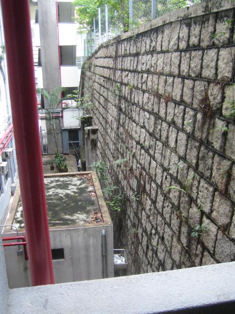
As an aside. the two air raid shelters built into the slope of Mount Shadwell are now exposed and clearly seen at the works site of the demolished Wanchai Market.

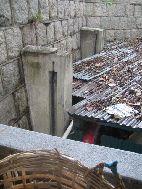
These well preserved stone crowns adorned the gateposts to the lodge at the foot of the Seamans Hospital that previously occupied the current Ruttonjee Hospital site.
You can see them in-situ in the old photographs of the Seamans Hospital elsewhere on this site. One historical postcard mistakenly labelled 'police station' shows them quite clearly.
It would be nice if they could be re-habilitated and used for an entrance elsewhere as they are in such crisp and good condition.
Rgds
J
I met Gary Tam at last week's HKICON talk. He believes that the AD stands for "Admiralty Department", similar to the stones we've seen with WD for War Department. He gave me this link to a page that shows the stones marked AD33 and AD13: http://www.seewide.com/space-article-id-268945.html
Since there's both AD33 and AD13, that means my idea of "Anno Domini 1933" doesn't make any sense. Instead these are likely two stones, numbers 13 and 33, out of a much larger set that outlined the boundary of this Admiralty Department lot of land.
Thanks to Gary for the explanation,
Regards, David

The missing gate post stone previously at Ruttonjee Hospital is now inside the Freni Care and Attention Home at Shiu Fai Terrace. I have posted a view available on Google Maps: http://gwulo.com/atom/26018

I have also posted an early photo (date unknown) of the hospital entrance at: http://gwulo.com/atom/26017

CM