Named after: the water channel that ran through it.
A creek starting just below (todays) Kennedy Road ran down the hill and drained into Victoria Harbour where (todays) Wanchai Road runs. Possibly as early as the late 1840s, when Queen's Road was built, the creek was diverted and ran covered under the street.
Timeline:
- 1850: Street first laid out, from Queen's Road to (todays) Cross Street
- 1858 Wanchai Market was built on top of the nullah
- 1866(ca.): Street extended to (todays) Johnston Road (after reclamation)
- 1866(ca.): Street extended to (todays) Lung On Street
The stone nullah ran through the middle of the street between Lung On and Queen's Road (see 1866 map on Gwulo).
- 1880s??: Street named Tsing Kai Lane (name appears on the 1889 map on hkmaps.hk)
- 1901??: Street renamed Stone Nullah Lane
- 1959: Nullah covered
- 2000(ca.): Street partly removed after area re-developed (The Zenit)
Other points of interest:
Pak Tai Temple, Wanchai [1863- ]
The Blue Block, #74 Stone Nullah Lane, Wanchai [1922- ]
Sources
Current condition
In use
Date street completed
(Day, Month, & Year are approximate.)
Photos of this street:
(see more)Photos of this street:
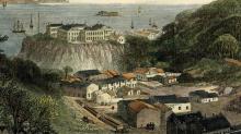
1873
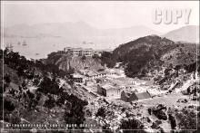
1870s
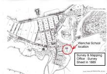
1889