Who: If we could zoom in close enough to see anyone, there's a better than average chance they'd be Scottish! Typing up the Jurors Lists certainly gives that impression (check out the names from the 'Quarry Bay' district [1]), and other snippets confirm the area's large Scottish community:
- In 1925 Hong Kong had five British-only Scout Troops, one of which was the "Taikoo Scottish" troop. [2]
- In the 1930s, many of the congregation at Union Church on Kennedy Road were Scottish workers from Taikoo Docks. [3]
What was the link with Scotland? Jardines have a clear Scottish Heritage, but Quarry Bay was Swire's land and their roots are in north England: Yorkshire via Liverpool. [4] Any suggestions?
The photographer is another mystery. The only clue to their identity is a handwritten caption 'Hong Kong Harbour' on one photo. The generic comment suggests they didn't know the area well, and so were new to Hong Kong. Most people would arrive by ship in those days, and would pass by here on their way into the harbour. An arriving tourist taking photos from a liner perhaps?
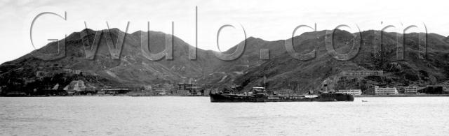
Where: We're looking south from the ship towards North Point and Quarry Bay. Here's a Google satellite view of the area (I'll explain the grey section in a moment), flipped 180-degrees to match the photo.

I've noted three landmarks we can see along the photo's skyline:
- A - Mount Parker (the peak at the 'u' in the photo's watermark)
- B - Quarry Gap (the cut near the 'o')
- C - Mount Butler (the peak between 'o' and ',')
What: Most of the area you can see was part of Swire's business empire.
On the right there's a long building up the hillside, Braemar Terrace. (A Scottish name again!) I don't know if it was owned by Swire, but a 1942 year-book lists it as the mailing address for the "Engineer-in-Charge, Taikoo Sugar Refining Co., Ltd." [5]
(Does anyone recognise the individual buildings on the seafront below it?)
There's another small building a little way up the hillside under the 'o' of the 'Gwulo' watermark. I think that's the Quarry Bay Junior School, where children of Taikoo's workers went to school.
The buildings along the shoreline in the centre of the photo are the Taikoo Sugar Refinery, roughly the area of today's Taikoo Place. The only reminder left is the streetname 'Tong Chong Street'. Its literal translation is 'Sugar Factory Street'.
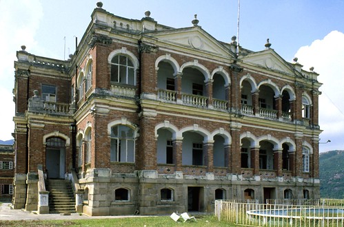
Over on the left are another couple of buildings up on a hill. They're on top of the ridge known as Korn Hill. The buildings were housing for Taikoo staff, and one of those staff, Mr Ferdinand Korn, gave the hill its name. The name lives on as today's Kornhill estate, but the old houses (and most of the hill!) are gone. Here's how they used to look:
Then we don't get a very good view of it in this photo, but the shoreline in front of Korn Hill housed the other big Swire operation in the area, the Taikoo Dockyards:

The final 'what' for this photo is my guess at the reason the area appealed to Swire. You can see that the area behind the refinery is a valley. There's a lovely walk around it (the Hong Pak Country Trail) that gives a very clear feeling you're walking around the edge of a bowl. That bowl is a great way to catch rain and feed it to housing / industry at the mouth of the valley. The grey area on the satellite view above shows just how large the water catchment is.
A good water supply was a big problem in Hong Kong for many years. I believe the sight of this catchment may have been the draw for Swire to build here. They certainly made the most of the resource, laying concrete channels along the hillsides to catch all the runoff, and building a string of reservoirs near the mouth of the valley.
The reservoirs are long gone, but you'll still see many of the small water channels as you hike the area, feeding into a large concrete channel that runs down the centre of the valley:


When: The seller described it as 'c.1940'. Can anyone confirm? Braemar Terrace has dark areas and light, almost like the camouflage applied by the Japanese to certain buildings during their occupation. That would date this photo to post-war.
Other: This started out as two photos. I've scanned and stitched them together on the computer.
Any more information you can share about the area is very welcome,
Regards, David
References:
- Jurors list: http://gwulo.com/jurors-list-1908
- Scout troops: http://www.scout.org.hk/article_attach/12248/hks303-p13.pdf
- Union Church: http://gwulo.com/union-church
- Swire history: http://www.swire.com/eng/about/history.htm
- 'Braemar Terrace' in Google Books: http://www.google.com.hk/search?hl=en&safe=off&client=firefox-a&hs=qiT&…
Reference: A083
Comments
Re: 3 building blocks below Braemar Terrace
Hi there,
I really have no idea of these three blocks. But based on the location of Braemar Terrace, the area should be more or less around present day Healthy Street East and Mansion Street.
Cannot distinguish if the three blocks are on the water front, or the southern side of King's Road either.
Best Regards,
T
Scottish Population of Quarry Bay
I think the answer to the significant Scottish population of Quarry Bay must, in no small part, be related to Taikoo docks.
The Taikoo dockyard (begun in 1900 and finished nearly a decade later) was championed by Swire's senior partner of the time, James Henry Scott. Scott was a scion of the Glasgow shipbuilding family, Scotts & Co, and he drew heavily on the expertise of the Clyde workforce to both build and operate the docks. The docks operated in Quarry Bay until the early 70s and would have constantly drawn on the experienced Scottish workforce throughtout that time.
Regards
Rob Jennings
re: Quarry Bay
Thomas,
I think you've got the right location. I've just found an aerial photo from 1944 that shows the same three buildings in front of Braemar Terrace. Scroll down to the first aerial photo here (it has 'North Point Camp' stencilled on it). The Terrace and the three buildings are at the right edge of the photo - if you look at the shadow of the centre building you can see the shape of its tower we can see in the photo above.
Rob,
Thank you for the information about the connection to the Clyde shipbuilders. I've also received an email from Alan Loynd thinking along similar lines:
Engineers tended to be Scottish (lots of them still are). So shipyard personnel probably served their apprenticeships on the Clyde (where Swire had close links to Scotts of Greenock).
Thus it is no surprise that Taikoo imported Scotsmen for their HK shipbuilding and ship repair facility (and probably for the large lumps of machinery at the sugar refinery)
The tanker would be worth a closer look. Are there any funnel markings? The style (without enlargement) could indicate immediately post war or, just possibly, pre-war. I suppose the lack of any obvious bomb damage might indicate that 1940 is a reasonable estimate.
Regards, David
Quarry Bay-Taikoo Docks location choice
From an in-house hardback book titled “Fifty Years of Ship Building and Repairing in the Far East” published by The Taikoo Dockyard and Engineering Company of Hong Kong Limited.
Publication date appears to be around the mid- 1950s.
History
On 1st January, 1867, John Swire & Sons, who had been established as Merchants in Liverpool since 1812, opened their first Branch in China at Shanghai under the trade name of Butterfield & Swire. This business later spread to Hong Kong and to all the major ports in China and Japan. In 1872 the China Navigation Co., Ltd., was formed under the management of John Swire & Sons, and since that date has operated services on the Yangtsze as far as Chungking and Suifu, along the China coast from Canton to Manchuria, and overseas to Malaya, Siam, Indo-China, the Philippines, Indonesia, Japan and Australia.
With their experience of ship owning in Far Eastern waters, John Swire & Sons decided that a fast-growing seaport like Hong Kong needed additional docks with modern facilities for the repair of ships and machinery. In the Spring of 1900, therefore, John Swire & Sons determined to construct a large graving dock, slipways, building berths and engine works at Hong Kong. Surveys of likely situations for a dry dock were made by Mr. William Danby, and it was decided that a position east of the Taikoo Sugar Refinery (which had been built by John Swire & Sons in 1882/1884), would be most suitable for the purpose.
An area of 52 acres of land and water, with marine frontage rights and power to reclaim was bought from the Government at Public Auction. This is an ideal position for a dockyard, as it is immediately inside Lye Mun Pass, which is the deep water entrance to Hong Kong Harbour, and the site has sea frontage with deep water on the north and on the east.
The work of advising and preparing plans was entrusted to Mr. John Scott of the shipbuilding firm of that name at Greenock; on his death in 1903 his brother Mr. R. Sinclair Scott took up the position of Technical Adviser, which has been held by the firm ever since. Early in 1902 it was decided to engage a leading Civil Engineer from England to take charge of the work, and Mr. D. Macdonald, M.Inst.C.E., who had previously been in charge of the Dover Harbour Works, was engaged as Chief Engineer and went out to Hong Kong in 1902.
The land chosen was at first sight not attractive for the purpose, as it was composed of three spurs of rock running from 200 ft. above the base of Mt. Parker to the sea. The preparation of the site was, therefore, a major undertaking; of the total original area of 52 acres, about 20 acres had to be reclaimed from the sea, and the remainder excavated from the rock. The levelling of the ground entailed the removal of 1,600,000 cubic yards of decomposed and solid granite.
The conversion of this rugged hillside and inlets from the sea into a dockyard for the building and repairing of ships was regarded by many as a foolhardy enterprise, but the vision and faith of the pioneers in the future development of Hong Kong has been justified.
The “History” carries on listing ships built, the war years and recovery.
A following chapter describes some of the Managers. The first one being from the North-East of England, but subsequent ones were all Scots.
Quarry Bay photo-tanker
The funnel marking, and vessel profile, suggest to me that this is probably a Royal Fleet Auxiliary (RFA) tanker, most likely of the immediate post war period.
regards
HO Lim-pemg
Taikoo Dock
The buildings on the hill to the right of the photo are the original Bramaer Terrace, which was occupied by both dockyard and sugar refinery staff. My parents lived there in 1954 before moving to Stanley Terrace, which is under the down stroke of the U. Stanley Terrace was ona hill above Gregg Road and Yau Man Street. There were two large dams serving the dock and sugar refinery to the east and north west of Stanley Terrace and further dams up the valley leading to Mount Parker. The water supply also served the local population in Quarry Bay, Shau Kei Wan and North Point. I believe the dams were part of the land deal for the dockyard as was the extension to Kings Road from Quarry Bay to Shau Kei Wan. Closer images of the buildings in the photo can be found in Historical Photographs of China link in this group.
The large colour photo is Korn Hill East, which was divided into two houses around the central axis. It came complete with garages and other rooms in the go-downs, together with large roomy quarters for the senior dockyard managers. Both Korn Hills (East and West) are the buildings above the dockyard in the b/w photo. Korn Hill West was the older house and was originally Mr Korn's house, before the dockyard converted it into two flats. (I lived in the lower flat for a short while in the 1970's).
The staff were from mainly Scotland and Glasgow in particular but there was also a very healthy smattering of English engineers from North East England and Liverpool. I believe that the ships built by Taikoo Dock used a particular type of engine of Scotts origin, that was built under licence.
Quarry Bay School was originally built by Swire's for their staff but was also used to educate other children who lived on the west side of the island from Stanley round to North Point. The school was taken over when the English Schools Foundation was formed and dockyard children continued to be educated there until around 1978 when the dock finally closed and those that were left from the merger with Kowloon Dock moved over to Whampoa Court, which was above Kowloon Dock in Hung Hom.
I believe Swire's also built schools and housing for the local workers. Some of the dockyard flats still exist in Shau Kei Wan and Sai Wan Terrace, one of the last remnants, although privately owned by local contractors, has recently been demolished and replaced by new flats.
There are two Facebook groups regarding the Old Quarry Bay School and Taikoo and Kowloon Dock Families, if want to view more photos of the area. However, most are people shots and some are commonly found on the web.
Scots, Scotts of Greenock and the Taikoo Dockyard
Rob Jennings is being commendably loyal; the company histories record that John Swire, the Senior, was opposed to the building of a dockyard in Hong Kong and the project, long discussed, was approved only after his death.
The dimensions of the graving dock were settled to suit the Royal Navy, who thereby provided a guaranteed revenue stream as the existence of the dock allowed them to deploy large ships to the East and South China Seas.
The Swire and Scott families intermarried twice. Scotts built over one hundred ships for Swires at Greenock, not counting the many ships built at Taikoo.
Very often one ship of a pair of sister vessels would be built at Greenock and the other at Taikoo Dockyard.
Taikoo Dockyard came out of new ship construction when the growth of the Japanese export shipbuilding industry made it hard for Taikoo to compete; I recall Peter Barnard saying that the "message" was spelled out by sucessive deliveries of steel plate ordered from Japan turning up in the wrong sizes... Taikoo got the message and withdrew.
The diesel engine associated with Taikoo Dockyard was the Taikoo-Doxford; there is or was a superb apprentice-built model of a Taikoo-Doxford at HUD; maybe it is now in the Maritime Museum.
To this day, a lot of the furniture in Swires company flats was made by Scottish cabinet makers working at the Taikoo Dockyard. It's indestructible!
Scots / tanker / buildings
Thanks very much for all your thoughtful replies. We can cross the link with Scotland off the list of questions.
The tanker
Stephen Davies replied by email, and also believes it's an RFA tanker:
The point of interest is the tanker in the foreground. She is not as far as I can see the standard T2, which dominated the market after the war, the T2 being the liquid bulk equivalent of the Liberty ship. The photo contrast is none too hot, but from the livery as it appears I'm inclined to think this may be an RFA (Royal Fleet Auxiliary). It has much of the air of one of the British T2 spin offs, the RFA Olna class. However, the fit is not that good (bow profile a bit too straight), so I'll have to hunt around a bit to get a firmer identification. With that, it may be possible to venture a dating.
There's a possibility of a pre-war date, though in general pre-WW2 tankers had a different and more evidently old-fashioned [general appearance].
My hunch would be early-ish in the 1950s, possibly late '40s.
The buildings
I think I've got a match for the building on the left, partly hidden by the tanker:
Detail cropped from this larger photo: https://gwulo.com/node/8770
Take a look at this photo in Tony Banham's 'Not the slightest chance':
It's titled 'Commercial Press printing house at North Point', and dated c. 19 Dec, 1941. The general shape of the building and the number of windows match the one in our photo. If they are the same, the heavy damage in the 1941 photo suggests it would have been demolished post-war, making our photo a pre-war photo.
Regards, David
Taikoo Dock
Andrew, you're absolutely right about two things - it was a doxford engine, that's one of the reasons my dad worked for Taikoo (he was an engineer at Doxfords Sunderland) and I still have some of the furniture from the dockyard. It must be about 50 years old and still going strong.
Re: Commercial Press Printing House
In the 1934 PWD Annual Report, the Commercial Press Ltd's Printing and Book Binding Factory and National Lacquer and Paint Product Co's Factory were completed on Shaukiwan Road (today's King Road).
Re: Commercial Press Printing House
Moddsey, thanks for that info. I followed up with a search through the newspapers and found this article about its opening. It gives the location as: '...on the foreshore at North Point, directly opposite the Ming Yuen film studio. This site was reclaimed ...', it also says that the building 'fronts the 100 feet-wide Shaukiwan road'. That description doesn't seem to fit the location of the building in the original photo, so maybe it's not the one.
Tanker indicates post-war
Thanks to Stephen Davies for his additional research:
I have a trace memory of a photo of the terrace after WW2 looking worse for wear, which is what made me look at it a bit more closely. In p.219 of Hal Empson’s Mapping HK, there’s an aerial photo, 1945, where the top right corner has the right hand end of the photo and things fit very well.
What now clinches the post WW2 judgment is a closer look at the tanker. On inspection there are Carley floats in their wartime positions and on the forecastle an obvious WW2 gun platform.
There’s an outside chance she is the USS Soubarissen, a US fleet oiler that was working out of HK in 1945/46. The only image I have of it is just after launch from the Starboard bow, so no use at all. The general appearance is faintly that of a US rather than a British design, though that’s not much to go on! Between 1945 and 1947 a couple of this class passed through HK – the other I know of being the Tamalpais. My reservation is the length of poop aft of the funnel and the tall, narrow funnel, neither of which were very US Navy.
re tanker
good photo of USS Soubarissen here: http://www.shipscribe.com/usnaux/AO/soubarissen1-08.jpg
Tamalpais here: http://ussao96.com/
Re: Commercial Press Printing House
Hi there,
According to the news clip the approximate location of it would be somewhere along the present day Northern side of King's road between Ming Yuen Street West and Shue Kuk Street. I think Shue Kuk Street 書局街 was to commemorate such a printing facility back then.
There is also a Wiki piece in Chinese saying they moved to North Point in 1934. Maybe the building in the original photo was also built by the same architect/contractor using the same design?
Best Regards,
T
Tanker, Commercial Press
80sKid, good finds for those photos. Looks like Stephen's concerns about the shape of the funnel were spot on, and it isn't either of these two ships.
T, Thanks for the streetname connection - that's where the local knowledge is invaluable. I also feel like the two buildings are very similar. As you say, that might have been a local builder's popular style at the time.
Regards, David
Re: National Lacquer and Paint Product Co's Factory
David - I think I have found the buidling in the centre of the photo. It would be the National Lacquer and Paint Product Co's Factory (later to be known as Camel Paint).
Please see their website: http://www.camelpaint.com.hk/corporate/en_history.asp and the expanded premises in 1946.
Braemar Terrace can be seen on the hill above.
Re: National Lacquer and Paint Product Company
Hi there,
That is an interesting find. But that bring a few more questions/facts:
1. That would help to date the original photo as some what1945 or even a bit earlier;
2. The 1946 photo in Camelpaint's site shown the expanded builting appeared to be doubling the size of the original one like an mirror image. If this is the case, the most eastern block would have been demolished when the expansion happened as there didn't seem to be sufficient space for the expansion.
3. We still don't know what had been the eastern and western blocks. However the western block looked like residents of sort with shops on street level.
Best Regards,
T
1940 or 1945?
Some interesting new bits and pieces for this one.
I think Moddsey has got the right building in the paint factory, dating the original photo to 1946 or earlier. But I don't think they needed to demolish the eastern building when they expanded the paint factory. If you look at the before and after photos, the 'arch & flagpole' is right of centre in the before photo, but in the middle of the wing after the extension. So the extended building wasn't quite twice as wide as the original. Also at the very left edge of the after photo you can see a sloped roof visible above the paint building, which I think is the eastern building.
I've confused things by asking if the date of the photo was pre- or post-war. A better question would be '1941 or earlier' or '1945 or later'. Because although 1940 was pre-war in Hong Kong terms, Britain was already at war. That affects the tanker, which Stephen notes had "Carley floats in their wartime positions". That could have been true in 1940/1. Here's a quote from page 12 of Tony Banham's 'We shall suffer there', dated December 1941 :
"We left that night on three of Thracian's Carley floats..."
So Carley floats were definitely deployed in Hong Kong in 1940/1.
The other update comes from Tony Banham. I asked him about the location of the photo of the Commercial Press Building. He replied:
The funny thing is that looking at this photo again the building seems to bear the legend 'Harrisons, King & Irwin' (see http://www.aim25.ac.uk/cgi-bin/vcdf/detail?coll_id=16859&inst_id=118&nv1=browse&nv2=repos)
So maybe it isn't a photo of the Commercial Press Building at all, and is a photo of the eastern building in our photo. When I look at Tony's photo, it looks like Taikoo in the background, which would fit the view past the eastern building better than the view past the Commercial Press location.
Regards, David
Doxford Engines built at the TAIKOO Dockyard
Dear Sir,
Do you know how to become a list of ship's names wich were equipped with DOXFORD ENGINES and built at the TAIKOO DOCKYARD
Awaiting your answer
Regards
Alfons
http://users.telenet.be/doxford-matters
re: Doxford Engines built at the TAIKOO Dockyard
Alfons,
I don't know the answer, but you might find some relevant information in the Swire's archives, as they were the company running the Taikoo dockyards.
Regards, David
Doxford Engines built at the TAIKOO Dockyard
Google--to find the SWIRE MARINERS web site as many of the contributors will have sailed on Swire/Taikoo built ships.
Also try the Hong Kong Maritime Museum web site for enquiries. They hold Taikoo material
Hallo DAVID and IDJ thanks
Hallo DAVID and IDJ thanks for the information
I will try to get more information
Alfons
The RFA Oiler
Last month in London I met Tom Stanley at a postcard fair. Tom's card says he specialises in 'small maritime items', so I wrote to get his opinion on the ship in this photo. He replied:
My immediate thought, rightly or wrongly, is RFA oiler
To me it looks like the "Eagledale" class - which makes her "Eagledale" "Easedale" or "Ennedale" - all of which served in WWII in the Far East.
With that help and a bit of googling I arrived at the Historical RFA website, and their page about Dale Class Tankers. It certainly looks like the ship above was one of the Dale Class tankers, but which one?
I've written to the website's editors, to see if they can recognise which it is.
Thanks to Tom for his help,
Regards, David
Not a Dale-class RFA tanker
Thanks to Chris at the Historical RFA website for his help:
My man has come back and he believes your ship is NOT a Dale Class tanker from the RFA. He has come to this conclusion based on a number of factors such as the position of lifeboats, the number and type of masts and their positions, the fact that most of the Class had a pair of large prominent ventilators forward of the bridge which are not on the photo in question, and the position, height and thickness of the funnel in relation to the aft accommodation block.
With that, we believe she is not an RFA - which ship she is however is still open.
So, back to the drawing board!
Regards, David
PS Chris also explained the origin of the name 'Dale' -
As far as how the Dale Class came to be named - sorry it wasn't through your local village. [I'd wondered if it was related to Dale in Pembrokeshire] The Admiralty had/has a naming committee and they named the Class after the various 'Dales' in northern England - Bishopdale, Derwentdale, Dinsdale etc.
Managers
I am trying to get a copy of the book specifically to find out more information about Bertie Bell - manager during 50s, and his father William. - Family research - we have 9 Frederick Augustus Bell Wallaces in our family and Im trying to find the connection!!!
Anne Stevens (nee Wallace)
1940s Quarry Bay
Some interesting comments by email from Dick Worrall:
Ref the photo described as "Quarry Bay". When I first saw it I thought it must have been taken from a vessel of some sort or the vicinity of the old Shell storage depot (which frequently had oil tankers and other vessels anchored off or moored alongside) across the bay from Taikoo Docks. After studying it more carefully, I would say the photographer was closer to Quarry Bay and therefore on a ship of some sort.
Like yourself and others, I have zoomed in etc and the row of flats/houses on the hill behind the vessel are indeed the old Braemar Hill Taikoo Sugar Refinery (TSR) European Quarters. The block lower down immediately behind the ship's forward superstructure/bridge were also TSR quarters (mostly rented out after the war) - next to where the Caltex petrol station (at least the 2nd generation one) is today and very close to where the Japanese landed next to the old Ritz. The actual refinery buildings must be the tall squarish ones near the water's edge to the left of the ship. Kornhill (senior Taikoo Dockyard European staff quarters) is there but Stanley Terrace seems to be obscured as is "Woodside". Quarry Bay School is definitely there.
Now, using my ancient memory cells, I recall that across King's Road opposite steps up to Quarry Bay School there was a small "nullah" and on the other side of that were "godowns"/factory buildings belonging to Davy Boag as well as the paint company (Camel?) and Wheelock Marden (my memory cells are not 100% sure about Wheelocks....). It is possible that some of the buildings on the foreshore behind the forward part of the ship are connected to those firms but from their size I would say that they are more likely to be part of TSR and that the godowns are somewhere behind them.
Taikoo Dockyard looks pretty deserted (can anyone make out their cranes?) with nothing in front of the steel storage sheds and no sign of their "new" West Gate HQ building.
Another question is: what is the vessel doing down in that part of HK? Ships due into he dockyard usually stood off a little closer and those swinging their compasses were located further to the east. TSR had their own pier where they unloaded molasses etc and shipped out from (more cockroaches on it at night than all the rest of HK put together!) so it cold be connected with that but if, as your shipping experts say, its an "oiler" that is unlikely. I also think that the nearest dangerous goods anchorage was further over to the west.
It is a pity one cannot zoom in and see things a bit more clearly. If the Taikoo quarters looked in a bad state (and the Braemar Hill quarters certainly do, some even look to have no doors/windows - i.e. post looting, as they all were) it would, to me at least, indicate that this was during or just post war as the Japanese poured oil over all the buidings to give any Allied plane on a recce the impression they were bombed out. No matter how often they were re-painted after the war the oil would still come through. The presence of the ship also makes me think that the shot was taken not long after the war had ended.
Tai Koo Sugar Refinery
My father William (Bill) Phillips worked at Tai Koo as a chemist in the early 1950's and we lived at No. 1 Braemar Terrace. I went to Quarry Bay School during those years.
I used to live at Korn Hill
I'm trying to look for a childhood friend who lived in Korn Hill during the 70's, his name is Geoff Douglass. My childhood nickname is JJ. ^^
I used to live at Korn Hill
I'm trying to look for a childhood friend who lived in Korn Hill during the 70's, his name is Geoff Douglass. My childhood nickname is JJ. ^^
Are you Geoff that I know in the 70's.
I'm JJ!
Hi Jay/Alan, It's been a long
Hi Jay/Alan, It's been a long time. Please contact me on either facebook or my email is geoffdouglass@hotmail.com Really looking forward to catching up. Regards Geoff
LOST AND FOUND!
Woo...finally! My FB = chlalan@hotmail.com