Though it was described as a stone bridge, it was actually a pier, extending out into the shallow waters of Kowloon Bay. It was first built in the 1870s by the Chinese government, enabling easier access to Kowloon City by boat.
The pier changed shape several times, as reclamation ate it up from the landward end, and different extensions were added to it at the seaward end.
It disappeared from sight completely in 1942, during reclamation for the expansion of Kai-Tak airport by the Japanese.
The closure of the airport in 1998 meant there it was possible to excavate the area. This was done in 2008, showing that several sections of the piers were still in place.
Here's a timeline of the main events:
1873-75 - The Lung Tsun Stone Bridge is built from granite
The original pier was built of granite. It measured about 210m long and 2.6m wide, and was laid in the direction of N131-degrees. The works were completed in 1875. [1, item 4.4.2]
At this time, this lay outside of British territory, which only extended as far north up Kowloon as the line of today's Boundary Street.
1892 - Wooden extension added
To reach even deeper water, a timber extension was added. It measured 80m long by 4m wide, and was laid in the direction in the direction of N118-degrees. These extension works were funded by Lok Sin Tong, a local charitable organization of Kowloon City Market, established in the 1880s. [1, item 4.4.4]
1898 - The pier lies within the New Territories
After Britain leased the New Territories from China, the pier was inside British territory. However, the 1898 Convention made two exceptions: Kowloon City would remain under Chinese jurisdiction, and Chinese men-of-war could use the pier. Here is that section of the text [2]:
It is at the same time agreed that within the city of Kowloon the Chinese officials now stationed there shall continue to exercise jurisdiction except so far as may be inconsistent with the military requirements for the defence of Hong Kong. Within the remainder of the newly-leased territory Great Britain shall have sole jurisdiction. Chinese officials and people shall be allowed as heretofore to use the road from Kowloon to Hsinan.
It is further agreed that the existing landing-place near Kowloon city shall be reserved for the convenience of Chinese men-of-war, merchant and passenger vessels, which may come and go and lie there at their pleasure ; and for the convenience of movement of the officials and people within the city.
The status of Kowloon City would be an ongoing point of disagreement between Britain and China over the following years, but I haven't seen any complaints about of a lack of Chinese access to the pier during that time.
1899-1900 - New name: Kowloon City Pier. New timber.
The 1899 and 1900 Annual Reports of the Public Works Department (PWD) noted that the timber section of the pier, which they now called "Kowloon City Pier", had decayed and was reconstructed. [3]
This 1903 map of the area [4] shows Kowloon City (G) and the pier (C). The letter C is over the granite section of the pier, then the lower part is the timber section.

1908-10 - Concrete replaces timber
It seems the 1899-1900 'reconstruction' of the timber section was actually a more minor set of repairs, because the PWD's report for 1906 [5] says:
The timber portion of the Kowloon City Pier was however in such a decayed condition that, in view of the fact that it has been decided to replace it with a reinforced concrete structure, no repairs were undertaken.
The solution was to replace the timber section with a new section made from concrete. We can follow the progress in the following years' reports from the PWD:
- 1908: 27 reinforced concrete piles were made for the Kowloon City Pier. [6]
- 1909: The concrete piles were driven into the seabed, and the area around the pier was dredged. [7]
- 1910: The concrete pier was completed. It measured 149 feet long, with two sets of steps at the outer end. [8]
The 1910 report also notes that two launches were allowed to start running a ferry service to and from the new pier.
1920s - Northern part of the granite section is buried under reclamation
Starting from 1916, a new sea wall was built across the northern section of Kowloon Bay, and the area behind it was reclaimed for the Kai Tak Bund project [9]. The line of the new sea wall cut across the granite section of the Kowloon City Pier, so the northern part of the pier was buried under the reclamation. I'm not yet sure which year that happened, but it was likely in the early 1920s.
The southern part of the pier's granite section, and the concrete part, remained in use. The following years' PWD annual reports mention repairs to the pier.
1934 - A new causeway provides easier access to the pier
In early 1934, the government issued a tender for "... the dumping of pell-mell rubble to form a causeway to Kowloon City Pier and the surfacing of same with cement concrete ..." [10]. The work was finished in December of that year [11], and I believe that is the layout we see in the map below.
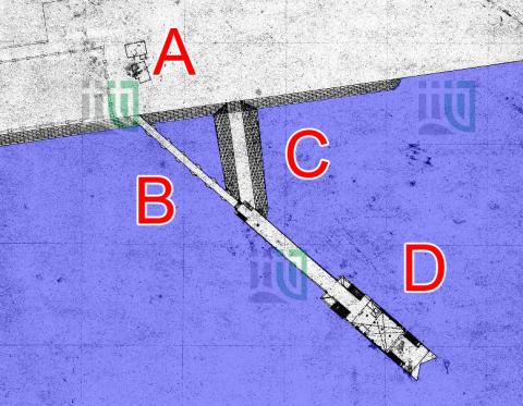
So I think we're looking at:
- A: The sea wall and reclaimed land
- B: The southern end of the granite section of the Lung Tsun Stone Bride. (The points of the hexagonal pillars can be seen.)
- C: The 1934 causeway
- D: The concrete pier, either from 1910 or 1937 (see below).
The map collection says the map is from 1922 though, which conflicts with it showing the 1934 causeway. More work is required to confirm exactly when the map was drawn and what it shows.
1936-7 - Reconstruction
In 1936 the government issued another tender [12], this time for "Reconstruction of Kowloon City Ferry Pier". (Note the addition of "Ferry" to the name.) It says the work comprises: "the reconstruction of the pier in reinforced concrete involving the construction of R. F. C. walings, bracings, landings and steps, decking, roofing, booking offices, barriers and other contingent works."
Before this work began, the pier was made up of the three parts shown in the map above: the southern end of the original granite pier, the concrete pier from 1910, and the causeway from 1934. I'm not sure whether the reconstruction applied to all three parts, or just to that concrete pier from 1910.
The newly reconstructed pier opened in March 1937. [13]
1942-5 - Lost from sight
During the Japanese occupation of Hong Kong, they reclaimed more of Kowloon Bay to expand the Kai Tak airfield. All three parts of the Kowloon City Pier were buried under this reclamation, and disappeared from sight.
2000s - Re-discovery
Kai Tak airport was closed in 1998, but it wasn't until 2008 that excavations revealed that at least some of the old pier had survived. Further excavations showed there were significant remains. It was decided to re-bury and preserve the remains, with the plan to later excavate them again and make them accessible to the public.
As I write this in August 2022, that excavation work is currently under way.
References:
- See the numbered item in Annex B of the AAB's Board Paper ref: AAB/30/2009-10, "Remnants of Lung Tsun Stone Bridge in Kai Tak Area".
The board paper gives a brief overview, with more information in the four annexes: - Full text of "Convention between the United Kingdom and China Respecting an Extension of Hong Kong Territory".
- Item 29 of the Public Works Department's Annual Report for 1899, and Item 14 in their report for 1900.
- 1903 Map of Kowloon
- Item 37 of the Public Works Department's Annual Report for 1906.
- Item 86 of the Public Works Department's Annual Report for 1908.
- Item 89 of the Public Works Department's Annual Report for 1909.
- Item 93 of the Public Works Department's Annual Report for 1910.
- Kai Tak Bund reclamation
- Tenders invited for Raising Level of Causeway to Kowloon City Pier: GA 1934 (suppl) no.97
- Item 184 of the Public Works Department's Annual Report for 1934.
- Tenders invited for Reconstruction of Kowloon City Ferry Pier: GA 1936 (suppl) no.273
- Item 178 of the Public Works Department's Annual Report for 1937.
Photos that show this Place
Comments
I think the statement that
I think the statement that Kowloon City Pier(Luang Tsung) were built in 1873 is inaccurate. The "stone" bridge was built in 1873, but before the Chinese government converted it into stone bridge, it was wooden bridge.
Kowloon City Wooden Pier
It was taken around late 1860s. In any case, it must be before 1873.
Re: Kowloon City Wooden Pier
The Conservation Management Plan for the site of Lung Tsun Stone Bridge mentions briefly that "Prior to the construction of Lung Tsun Stone Bridge, a short wooden pier was probably built to meet the increasing needs of gambling houses fronting the beach, the merchants in the market and the officials and navy of the Kowloon Walled City."
You are right, I didn't
You are right, I didn't notice that. The word "pobably" can be deleted.
Long Tsun Stone Bridge - Sha Tin Central MTR line
The MTR Sha Tin Central MTR line current plan will put the Long Tsun Stone bridge at risk of demolition.
re: Long Tsun Stone Bridge - Sha Tin Central MTR line
Hi Annelise,
Please do you have any links to more information about this?
Looking at the Conservation Management Plan for this old bridge (Dated November 2009. See 'Annex D' above), the executive summary includes:
4. A set of conservation guidelines, based on recognized charters and
principles, is proposed as a framework to guide the conservation,
management, maintenance and interpretation of the remnants in future. It is proposed that the remnants of original Lung Tsun Stone Bridge should be preserved in-situ. Moreover, no speculative recreation or excessive intervention would be allowed at the area buried with the original Bridge’s remnants.
Are the MTRC ignoring it?
Regards, David
Lung Tsun Bridge
This is the latest plan by the govt to Legco from last week:
Remnants of the Bridge and the former Kowloon City Pier have been discovered in the north apron of Kai Tak. Given its high historical significance, the remnants will be preserved in-situ as a special cultural heritage asset. This conservation approach was endorsed by the Antiquities Advisory Board in December 2009. A 2-stage public engagement (PE) exercise is being launched on conservation of the Bridge and its integration with KTD.
http://www.legco.gov.hk/lcsearch/showdoc.htm?mylink=/search/marker?s=31&o=2&t=2&a=15&r=2&k=1,&g=0&PROPERTY=2;&MERGEFIELD=-&CODECONVERT=-&SORTFIELDS=-&SIM_START=1&SIM_NUM=10&REL_START=1&REL_NUM=10&LINK=-&REDIRECTTO=-&PATHLINK=-&p=%22lung%20tsun%22&c=16,1&i=http%3A%2F%2Fwww.legco.gov.hk%2Fyr09-10%2Fenglish%2Fpanels%2Fdev%2Fpapers%2Fdev0525cb1-1919-5-e.pdf&j=7629&v=&n=&link=http%3A%2F%2Fwww.legco.gov.hk%2Fyr09-10%2Fenglish%2Fpanels%2Fdev%2Fpapers%2Fdev0525cb1-1919-5-e.pdf
Gwulo representative on Stone Bridge
A huge amount of the bridge is intact. A very impressive dig I must say, and puts even more romance into our old bits and bobs.
May I suggest that we deputize one of us to be the Gwulo representative to the Government to protect this bridge. Adding our voice to many others is how heritage gets saved.
Of course, I volunteer David :) to speak for me. The approved form is to email the relevant department, ask that we be included on anything they do (e.g. their proposed newsletter) that put us "in the loop" and they have a duty to keep us updated. We say that we are Gwulo, a volunteer online history group - and we are keen to ...
well keen to do what exactly ? Right now, we are keen to go spelunking online and in the woods to see what we find. But when we find it, we post it, and then what ... ?
What say you gals and guys?
re: Gwulo representative on Stone Bridge
Hi Annelise,
I hope gwulo.com encourages readers to share whatever we know about different sides of old hong kong. It could be something we've seen on a spelunking trip, online researches, personal experiences, family history, etc - it's all welcome.
Then make it as easy as possible to search through that information, and find other, related information that perhaps we weren't aware of.
Those are my goals for the website, and are enough to keep me busy :-)
I'm not planning to have the site act as a monitor, watching different government departments for potential damage to heritage sites. If there's an actual risk of damage, it deserves to be brought to people's attention, and gwulo.com is a good way to do that. But the watchdog role I'm happy to leave to groups that focus on it, eg The Conservancy Association.
What other watchdog groups are there out there?
Regards, David
Rebuild the bridge proposed
SCMP 5 Jun 2010
Planners have suggested recreating the 140-year-old Lung Tsun stone bridge, found in the Kai Tak redevelopment area, to attract tourists and showcase Kowloon City's history.
The bridge, built in the 1870s, functioned as a pier for official use in the Qing dynasty (1644-1911). Officials were welcomed at a pavilion close to it and were escorted to the Kowloon Walled City to execute their duties.
Lung Tsun Stone Bridge
The Civil Engineering and Development Department (CEDD) in collaboration with the Antiquities and Monuments Office and the Planning Department will organise two Community Envisioning Workshops to gather views from the public on the preservation of the Lung Tsun Stone Bridge whose remnants were unearthed in the Kai Tak development area.
Built in 1873, the 200-metre-long Lung Tsun Stone Bridge was once the landing pier linking to the access road to the Kowloon Walled City main gate. At the landward end of the bridge was a two-storey pavilion, which was once used to greet Chinese imperial officials, thereby giving it the name, "Pavilion for Greeting Officials". The bridge has since been modified or repaired many times as the area developed. It was completely buried in 1942 during the Japanese occupation in the Second World War.
The two Community Envisioning Workshops will be held at Lee Kau Yan Memorial School, 596 Prince Edward Road East, Kowloon, from 2pm to 5pm on June 19 and June 26. Site visits to the Lung Tsun Stone Bridge remnants will be arranged. Since the Lung Tsun Stone Bridge remnants are located within a work site, for safety reasons only participants aged 16 or above can join the site visit.
Members of the public can download the registration form from the website of the CEDD's Kai Tak Office (www.ktd.gov.hk). Completed forms should be returned seven days before each workshop either by fax or by mail (fax: 2369 4980; address: Kai Tak Office, CEDD, 7th Floor, Empire Centre, 68 Mody Road, Tsim Sha Tsui, Kowloon). The quota for each workshop is 100 and will be allocated on a first-come-first-served basis. Enquiries can be made on 3106 3432.