The AMO website has this description:
The former French Mission Building on Battery Path, Central, was built in 1917 by the French Society of Foreign Missions as its Procure of Hong Kong. The building was used briefly by the Government before Hong Kong fell to the Japanese in 1941. Immediately after the Second World War, it was made the temporary headquarters of the Provisional Hong Kong Government. The French Mission and the Hong Kong Govenmment signed a contract for the transaction of the building in 1952. Since 1953, the building was occupied successively by the Education Department, Victoria District Court, the Supreme Court and the Information Services Department. It housed the Hong Kong Court of Final Appeal between 1997 and 2015.
Dating from the Edwardian period, the three-storey building with a basement is constructed in granite and red bricks in the Neo-classical style. A chapel is incorporated in the north-west corner, where its cupola projects above the roof. It has undergone several alterations since the Second World War, but many historical architectural features can still be seen in the building. For example, the hall on the ground floor with its ornate columns, wooden staircase and vaulted ceiling and the well-proportioned inner courtyard qualify the building as one of the finest pieces of historical architecture in Hong Kong.
In the comments below, Herostratus notes the construction of this building was completed in 1919.
Photos that show this Place
Comments
“Residence of Augustine Heard
1. Residence of the Governor of Hong Kong between 1843 and 1846
http://www.devb.gov.hk/en/secretary/heritage/project8.htm
2. “Residence of Augustine Heard and Company, Hong Kong” ca. 1860, unknown artist.
http://upload.wikimedia.org/wikipedia/commons/8/87/Augustine_Heard_%26_…
re:French Mission/Cathedral
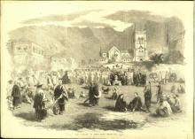
amazing painting Annelise - you can see Murray parade ground has yet to be levelled (now site of Cheung Kong) in front. Interestingly the picture (if accurate) shows the Cathedral's original colour scheme which St John's has recently reverted to -- from the previous white and green.
Matshed - or
This 1857 woodblock shows a large matshed where the residence should be.
click here to zoom
1876 Sale of Inland Lot No. 82 - A. Heard & Co Building
China Mail 23 June 1876
When the business of Augustine Heard & Co had begun to fail.
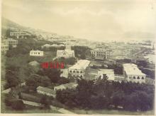
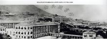
French Mission Building
As this prominent site has been built upon since early in the Colonial era, and the buildings thereon have seen a number of external changes over the years, it's a useful one to look out for when trying to date old photos. The timeline at;
www.hkcfa.hk/en/about/cfa_building/french_mission/index.html is very informative.
A curious marker stone
Those who fossick close around buildings find some puzzling things. A recent example I was asked about (and had to answer I hadn't clue) was a marker stone tucked right close into one of the corners of the outside of the old French Mission Building. It is set into the ground right in the corner such that only something like a knife blade or thick sheet of paper could go between it and the very cleanly faced stones of the lower courses. It is the height of the lowest 1/8th course that projects above the ground plus half the height of the first complete course. It is a simple, roughly rectangular stone, though seemingly well weathered since its corners are quite smooth. On the face one can see it has:
38
HBO
Aligned like that with the 38 lining up with the first letter below. The 38 may be 88, though that is not what one immediately sees.
The carving is such that he letters might also be HBO/C, HEC/O or even RBO/C, REO/C, although HBO is the immediate reading, with the 'O' very slightly smaller than the other two letters.
The 38 is in a very 19th century - and arguably early to mid-19th century stone mason's font.
I can connect this with no known HK boundary marker of any sort (the lot was I.L.82 as of Mr Johnston's day in 1842).Does anyone have any bright ideas?
StephenD
re: A curious marker stone
Could it be from the Heard and company era:
H&Co.
Regards, David
French Mission
Thanks David. I did wonder about that but couldn't manage to fiddle the B/R/E into an ampersand and still look at myself in the mirror. It also still left the '38' unexplained.
With regard to the '38' I wondered about a bearing (as an offset marker for indirect battery fire). However that sort of artillery tecnique really only dates from the last decades of the 19th century, by which time Murray Battery was obsolete and used for fancy waistcoats' saluting. It also left the HBO unexplained.
I also wondered about a military meaning. The 38th Madras Native Infantry was in town off and on 1857-1860. I can't think of a good reason why they'd have had a marker where the stone is, but it's a thought. Were the HBO to be HEC, then we'd have an uncommon acronym for the Hon East (India) Co.!
The only other possibility that occurred, remembering manhole markers from my childhood, was this as some sort of service marker (something similar exists all over HK marking the main lines of military communications cables from the WW2 era). The 38 would presumably be in feet and the HBO (or whatever it is) an indication of the service whose manhole/cable duct/whatever was 38' away (usually 90 degrees to the face of the marker).
A real mystery and still stumped.
StephenD
The initials HEC appear on
The initials HEC appear on various items belonging to the Hongkong Electric Company, but I haven't seen them use a stone marker stone before.
Regards, David
Marker stone
Thanks David - good to know that HEC is at least an acronym associated with the company.
It is small and slablike, i.e. wider across than it is in thickness, so more like a gravestone than a milestone/boundary stone, hence the recollection from childhood about conduit/manhole markers.
That would raise the question of when electricity was first brought to Government Hill and whether the supply line was brought up Battery Path. An explanation for the marker stone might be that it referred to an access point where, for example, the incoming supply line branched, one branch continuing to the Cathedral and the French Mission, the other to the Government Offices. This seems to me possibly the way to go since, for example, we learn that shortly after the founding of HK Electric in 1889, "At 6:00 p.m. on 1 December 1890, 50 street lights along Queen's Road Central, Battery Path and Upper Albert Road were switched on."
That raises the additional possibility that the number '38' referred to the number in sequence of the street light and the stone was in some sense related to the street light's power supply branching point.
If this is indeed related to the HEC and those first street lights, then it would seem to me historically important.
StephenD
Re: Marker Stone
Looked at the granite marker stone. It appears releated to the Hong Kong Electric Company (HEC). Have seen other inscriptions of HEC on markers, though not on a similar marker stone like this, but that have abbreviations and numerals (feet and inches) on them which I guess give the location and distance of the nearest electricity cable. Tend to think that next to the numerals 38 reads 38 " which may indicate the presence of an electricity cable 38 inches below the level of the ground.
marker stone
Thanks Moddsey - in an offline exchange with Mak Hoyin of the AMO we'd worked round to a similar view. Hoyin thought the numbering was 387 - which was a bit of a stumbling block. The only way I could imagine that worked was for the stone to be, rather than a classic marker for the location of a service access, a subscriber number.
Hoyin took the view that with the rounded corners the stone must be quite old (say <100 years), so my imaginative (!) reasoning hypothesized that in the early days, maybe to make it easier for HEC functionaries to identify buildings in which there were HEC meters to be read (and we know from newspaper records that is how billing was done from very early days), there were stone marker like these placed at ground level very close to a building's entrance and against the building wall - as is this one.
Were there to be an extant HEC customer list, that thought could be instantly shot down if customer accounts were not numbered or were no occupants of the Old French Mission Building ever customer account no.387!
StephenD
I have created a new place
I have created a new place for the building that housed Johnston's House/Heard & Co/Beaconsfield here as the PWD reports make it clear that a new building was built on the site rather than the original building being converted.I am unsure where the rumours of the building being converted form the old one originated.
1916 PWD Report: The erection of a new building for the Missions Etrangeres on Inland Lot 82, at the top of Battery Path, was commenced.
1917 PWD Report: Considerable progress was made with the erection of the new building for the Missions Etrangeres on I.L. 82.
1918 PWD Report: The new building for the Missions Etrangeres on I. L. 82 was nearing completion at the end of the year.
1919 PWD Report: The new building on I.L. 82 for the Missions Etrangeres was completed.
Completion date for the new French mission building should therefore be 1919 rather than 1917 as is commonly reported.
Former French Mission Building
No longer the Court of Final Appeal, which has re-located to the former Law Courts on Statue Square. Now part of the Justice Department offices.