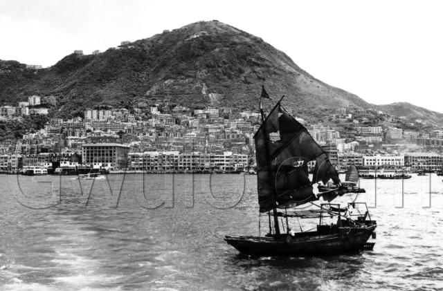
Over on the left are the white buildings of the old Vehicular Ferry Pier, with the pillbox visible on its western pier. The taller building behind it is the old Fire Station, where the Hang Seng HQ building stands today.
In the foreground of the photo we can see the wake from the boat that the photographer is standing on. It leads back in the direction of the pier, so there's a good chance the photographer was making use of a ferry ride to get this photo of the island.
Looking right from the pier, there's a string of shop houses running along Connaught Road C., the old seafront. Behind them we can see along a street that runs straight up the hillside. Graham Street, perhaps?
The next buildings are blocked out by the sails of a small junk. The sails are missing several sections, but that seems to be a common sight in photos from this time. In fact this one isn't too bad at all - sometimes there seems to be more hole than sail! There are only two people in sight on the junk, and no sign of any cargo. I wonder where they were going.
Looking to the right of the junk we see a small motorboat, then the sail of another junk (this time the sail looks in better condition), and behind that packed-looking Star Ferry. Behind them all is the white Harbour Office building. It's Vicwood Plaza now. The last building on the right of the photo is Wing On.
Now let's move up. At the right end of the Harbour Office is the tower with it's distinctive observation area on top. Looking up from that is an open area, then a solid, squat looking building, the Hop Yat Church.
If you look diagonally up and to the left of the church you'll see a large building standing on it's own, on top of a large platform. There's a ramp sloping up from the road to the top of the platform. I think that building is The Fairview, a building we've looked at before as hospital building in Love is a Many Splendored Thing.
There's no real high-rise building yet, so the hillside of the Peak still dominates the photo. It also means that the big, old buildings of Mid-levels are clear to see, and in turn had a clear view out to the sea.
I'm guessing the date as the mid-1950's, but please leave a comment if you can pinpoint the date.
Regards, David
Reference: A03

Comments
c.1954 View of the Harbour
Because Tregunter is not there, I would say no later than March 1955, when the new building became visible - according to the China Mail. (completed September 1955). My guess would be 1954, when the old block was demolished.
Alun
Re: Wing On Department Store
Hi there,
The big block opposite the Harbour Office was the Wing On Department Store. It was still there in the late 1960's.
There was a cinema behind the Harbour Office, on the Des Voeux Road side. I believe it was called 恒星戲院 back in the 1970's, but after googling a bit some netters posted old photos of it saying it used to be called 新世界戲院 (New World Cinema or something like that) in the 1960's or before. The Harbour Office only took up half the lot of occupied by the present day Vicwood Plaza.
Best Regards,
T
Re Tregunter
Out of curiosity, where is or where would Tregunter be in the photo? Cheers!
Tregunter
Hi Moddsay,
On the far left of the picture, the big building in the Center is Queens Gardens, to the right of that is the excavations for Glenealy School. The big white building above is Douglas apartments, (6 Stories) the lower white building to the left of that is Luginsland.
Tregunter should be behind Luginsland from that angle. It would be 12-14 Stories high, so it would stand out. The previous upper block was 3 stories high, so it should still be visible, although the lower block may be hiding behind Queens Gardens.
Re: Tregunter
Thanks Marlowe for the location.