I'm guessing 1910 as the date for this postcard, but corrections are welcome.
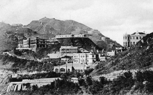
The excellent 1912 map (thanks to the anonymous submitter) shows what we're looking at. In the foreground is Chamberlain Road (called 'Peak Road' today), sloping down to the left, before curving round to the right and out of sight. Just above that is Treverbyn with the large arched window, and behind that we can see the back of the Peak Hotel. Further up the slope to the right is Formosa.
Above Treverbyn's left chimney is a modest little building, the No. 6 Police Station, then above that is a larger building whose name I can't read clearly on the map.
To the left of the Police Station, a road slopes up to the left. Just to confuse things, that used to be called Peak Road, but today is called Mount Austin Road! The road is overlooked by the imposing structure of the Mount Austin Barracks. I wonder what the temporary sheds are on the flat land above and to the right of the Barracks? Maybe they can help date the picture more accurately.
This picture comes from an unused split-back postcard, 'Published by M. Sternberg, Hongkong.'
Reference: A06
Comments
Hand-tinted version of the same postcard
1900's View of The Peak
It’s been over ten years since David and Annelisec posted their black/white and coloured versions of this postcard. High time for another look. Back then David posed two questions.
Coincidentally, Quarndon helps date this photo. It looks complete in the postcard. Its vacant site had been auctioned on 11 Aug 1902 and the house was reported to have been occupied by 19 Oct 1903. A building of this size surely couldn’t have been completed in under four months, so it must have been finished sometime between early 1903 and Oct 1903. Therefore, the photo must have been taken in or after early 1903.
Harlech Road is seen behind the base of the letters “G” and “W” in the Gwulo watermark on the black & white postcard. The PWD Annual Reports of 1903 and 4 described it as “about completed” and “completed” respectively, so support the idea that the photo was taken from 1903 onwards.
Establishing a narrow date range for the photo based on its contents is difficult, but fortunately I’ve got a copy of this postcard which can help. Its front is identical to Annelisec’s version above. Here’s its rear.
There are two postmarks. One is complete and reads;
“HONGKONG”
“C”
“27 AP”
“09”
“K 8”
I presume “HongKong”, “27 AP”, “09” means it was posted in Hong Kong on 27 April 1909. Can anyone please advise what the “C” and “K 8” mean?
The incomplete postmark seems originally to have been applied partly over a postage stamp, now lost, perhaps removed for resale. Part of the name “Hong Kong” can still be seen, but nothing else. I wonder why two postmarks were stamped on this card?
Assuming I am reading the date on the completed postmark correctly, the photo must have been taken before 27 April 1909. Therefore the photo must have been taken at sometime between early 1903 and 27 April 1909. As the terrace walls to the left and below Quarndon looks clean and new, I’d say the photo was taken early within this date range.
I have replied over here
I have replied over here
And yes the date is 27th April 1909.