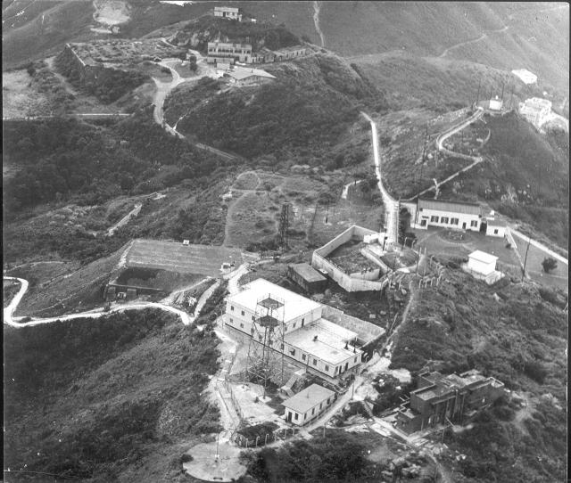
This photograph was given to me by the late Flt. Lt. Ken Sly, Officer Commanding the unit at Battys. In order to keep up his flying hours and the associated pay, Ken had to fly 10 hours each month, usually with other arcrew who were desk bound, ut who also wanted to retain their flying pay, as passengers. So, one day each week he flew, sometimes with Flt Lt. Ted Canton as his wing man, around the colony. Ken told me that, at that time R.A.F. Kai Tak only had two planes, a Harvard and a Meteor, on which Ken was qualified to instruct. He also had access to the small fleet of Auster planes of the Hong Kong Auxiliary Air Force. On this occasion he had taken his Senior N.C.O., Flight Sergeant, later Warrant Officer Franki Curzon up, and Frank was a very good photographer. Ken started his career in the R.A.A.F. and R.A.F during World War II as an operational Lancaster pilot. The photograph is unique as it shows the main features on the summit of the Peak. A very derelict area of ground in the top left corner is where the Governor's summer residence and garden used to be. The conical hill at top right is the site of the orginal Battys Belvedere. That and the zig zag path up it features on several Victorian postcards of the Blevedere, and the path is, I believe, still visible on Google Earth. The derelict brick house in the right bottom corner is the one that was reputed to be haunted. The two storey R.A.F building stands at lower centre and the circular platform where the Victorian signal mast used to stand is below it. The Victorian building associated with the original signal station is at the other side of the platform. Its curved roof is clearly visible. That building also features on several Victorian postcards. For many years I had 'remembered' that the old signal canon had been on the circular concrete platform but, as you will see below, that was a false memory, as it was on the grass fairly close to the derelict brick building. (Andrew S)
Comments
Great Photo
Thank you for posting. A good write-up. IWM has an audio here (Reel 3) of a linguist/interpreter and his impressions of Hong Kong and work at Batty's.
Lots to see!
Hi Andrew,
Thanks for posting this. It shows lots of things we've talked about before, and great to see them from above like this.
I can't spot the cannon, and wonder if it is just out of sight below the edge of the photo? In your colour photo you were looking down on it, and it was standing on a grassy area.
The derelict brick house is interesting too. Apart from it being haunted, did you hear any stories of what it may have been built for originally?
Regards, David
Batty's cannon
Good morning David,
I too have puzzled over the 'missing' cannon on this photograph and have wondered whether the dark object in what would seem to be the correct place on the left of the platform is it or just a bush. The otherwise high definition of the photograph would suggest it's a bush.
Ken told that that the aerial photograph was taken in 1958 but I suspect that it could have been taken a few years later, when he was still in Hong Kong. If that was the case it is possible that after 1958 when my colour photograph was taken any grass covering the Victorian circular platform could have been cleared and the cannon removed. I do not recall standing higher up than my friends and it would not have been unusual for me to have held my camera above my head to get more things in the picture. We were definitely standing outside the fence around Batty's and the circular platform was, and still is, the only flat area between the fence and the very steep slope. I'll check on a few more digital photographs that I have to see whether they can shed any light on things. Copyright is owned by other members of the 367 Association, so I'm not free to upload them onto Gwulo. The Victorian postcards might also shed some light on whether the cannon stood on the same platform as the signal mast - as I think it did. I believe that the cannon is now kept at the small Police Museum at Victoria(?) Gap. Documentation, there, might indicate when the cannon was removed from its original position at Batty's.
I hope that the above might clarify things a bit and not add to any confusion!
As always, I enjoyed reading your recent newsletter about Blue Pool Road.
best wishes, Andrew
Re: Peak Cannon
I guess the cannon is out of sight in the photo. From a signboard in the grounds of the Peak Police Station in 1995 as shown here
"This well preserved cannon is over 150 years old. In 1960 workmen demolishing an old buidling near the Peak radio station known as Batty's Belvedere found the gun in the undergrowth. Legend has it that is the same gun that was fired by the Victoria Peak Lookout in the early days of the Colony to signal the arrival of the Mail-boat."
It's a mystery. I'm certain
It's a mystery. I'm certain that my friends and I were standing on the circular platform. I think that it was probably overgrown with rough grass in 1958. We definitely would not have known about the Victorian signal station and we should not have paid any attention to the curved roof building that stood just inside the fence. The newer building between that one and the two storey main signals unit building was a cookhouse and possibly a small dining room. Somebody once told me that the red brick building that was rumoured to be haunted had been a house but it looks too austere to have been that.
Andrew
1939 Peak Signal Station Cannon
1980 View
A similar view in 1980 is here
Thank you both for solving
Thank you both for solving that problem! I have been wrong all the past 59 years. As I mentioned recently, in connection with the tunnel/cave window above the old camp road at Siu Sai Wan, visiting places just the one time in 1958 can lead to deeply held memories - but nevertheless erroneous ones - about their precise location. That old 1939 photograph definitely places the signal cannon lower down the slope from the concrete platform just as you recently suggested it would be. It's great that an apparently rather boring photograph should be capable of solving a problem. It just shows that we should keep all photographs in case they can be of historical use. Memory is a strange thing!
I'll leave the correspondence on this as it is as a warning to myself and others not to rely absolutely on one's memory!
best wishes, Andrew
Cannon
Hi Andrew,
Memory is a strange thing, as you say. I regularly find things I remember in one way are in fact quite different. Good to have the photos to help work things out.
Your colour photo of the cannon makes me think there were a couple of granite slabs in the ground for it to stand on. If that spot hasn't been built over, I guess they're still there. If anyone is exploring that area, please keep an eye out for them.
Regards, David
Cannon
Hi David,
One of the old photographs supplied by Moddsey in an earlier discussion in, I believe, 2012 shows several children on the cannon which is standing on four long granite blocks. Maybe they are still there.
best wishes, Andrew
Radar Station
The front page of the HK Telegraph of 25 June 1947 carries a story focused mainly on the upgrading of Kai Tak Airport, but also mentions a soon to be opened "radar station"..."on the highest point of The Peak". If taken literally, this must be in or around RAF Battys Belvedere, but the article makes no mention of any RAF involvement so it may have been an entirely civil aviation initiative. Mr. A.J.R. Moss, Director of Air Services, is quoted as describing the radar station as "a small brick building", to "be run by three-man shifts", commencing operations "in about three weeks".
The excellent photo at the head of this string shows Battys Belvedere and most of the rest of the top of The Peak in 1958. As this was only eleven years after the radar station opened, I assume it was still standing and am wondering if it can be seen in the photo?
RADAR Station
Thanks GW for this interesting comment.
There was no RADAR station in the R.A.F. Wireless compound on the Peak. However, in the 1950's there was an R.A.F. RADAR station in the ruins of the pre-war Army buildings on the top of Mt Davis, with the living accommodation for the small unit's personnel on the slightly lower platform on which the Youth Hostel now stands. My understanding is that the unit provided the RADAR service for the R.A.F. station at Kai Tak, but I might be wrong and it could have been associated with both military and civilian flights. Is it possible that the journalist simply mixed the Peak with Mt Davis?
Another rather remote possibility is, if the Peak is an accurate wording there is a small square shaped hut at the top of the zig zag path visible towards the top right of Ken's great photograph, but as far as I know it was not an R.A.F. installation. With what look like short aerial(?) masts near each corner it presumably had something to do with 'wireless' technology but I am not qualified to say whether that would be RADAR. In Victorian times the famous belvedere stood on that spot as shown in several of the images on Gwulo. Perhaps someone with greater knowledge of RADAR technology in the 1940s/50s might be able to explain them and which if ether of my suggestions is correct.
Re: "Radar Station"
The word "radar" mentioned in the article probably means as per early definition - radio detection and ranging.
The 1947 Hong Kong Annual Report that is available on HKPL does not specifically mention the type of installation on the Peak.
That said, I think the installation referred to was used for direction-finding purposes. Such station would provide a homing service and position information to aircraft on a designated radio frequency. In the case of the Peak, the signal used would be a very high frequency (VHF} one.
To confirm, I noted page 64 of Airport of the Nine Dragons (by Chic Eather) for the year 1947: "The Colony's navigational aids continue to be upgraded. There was a high and very high frequency (VHF) direction finder. Combined with a medium frequency, a beam approach and radar beacons the aids were comparable to other South-East Asian airports."
Hope this helps.
RAF Batty
https://www.forces-war-records.co.uk/units/624/raf-little-sai-wan?fbcli…
RADAR station
Thank you Moddsey. I have spoken with a friend from my service days and, having worked on DF (Direction Finding) outposts, he confirms that the usual layout would have been for a small, square shaped concrete building with a detached aerial mast off each corner. He believes that the building on top of the conical hill was a civilian one and was almost certainly the one in the newspaper article and was connected with the air traffic control measures introduced for Kai Tak after the war.
Radar Station
Fair enough, I've made a "place" for the Radar Station where the Eyrie's Belvedere previously stood, https://gwulo.com/node/58898
Re: Radar Station
This is one of the VHF(Transmitter Zone) huts in Victoria Peak Radio Station, not a Radar station.
Agreed. I think that…
Agreed. I think that Moddsey explained the apparent discrepancy very well in his contribution of 10/09/2022.
Hut, by hwtangaa
.
Re: RADAR Station
'Another rather remote possibility is, if the Peak is an accurate wording there is a small square shaped hut at the top of the zig zag path visible towards the top right of Ken's great photograph, but as far as I know it was not an R.A.F. installation'
Yes, all equipment is use for Civil Aviation.
Re: RADAR Station
Close view of the Hut. :)
Yes, that's the building to…
Yes, that's the building to which I referred earlier in this thread - on the site of the original Victorian pavilion at the top of the zig zag path. An old R.A.F. colleague who worked on direction finding told me that it had (and still has?) the typical configuration with the 4 aerial masts of other D.F. units that he had worked on.
Radar Station
Apologies for my ignorance regarding radar, direction finding, VHF transmitting and other related technical matters and jargon, but based on the above comments I'm unsure if the "place" ( https://gwulo.com/node/58898 ) I created for the RADAR Station is in the wrong location or has the wrong title.
Perhaps it would help if I included the full text of the 1947 newspaper article that mentioned the Radar Station. Here it is;
"Construction of a radar station on the highest point of the Peak is another important development in civil aviation. The station will go into use in about three weeks, Mr. Moss said, and its operation will add to the safety of flying in and out of Kai Tak.
Because of Hongkong's hills, sound waves are sometimes bent, making it difficult for Kai Tak to keep in touch with planes at certain periods. Mr. Moss said the additional radar station on the Peak "should eliminate that difficulty and make our facilities excellent".
The new station is in a small brick building and will be run by three-man shifts. It will give Kai Tak a much wider range of communications than at present."
Not sure if it contains any useful additional information, but most grateful for advice on any amendment required to the current "place" page for the RADAR Station.
Suggestion
Not sure if there is a name for the current facility/installation on the conical hill ? Is it all the Victoria Peak Radio Station? Perhaps hwtangaa can supplement as it appears to be used for civil aviation. Thanks.
Re: Suggestion
We called it VHF Transmitter Hut.
- Is it all the Victoria Peak Radio Station? Yes.
No Chinese Defence Force military equipment inside this hut.
VHF Transmitter Hut/VDF
Thanks. Based on the above comments and those of tloughuk at https://gwulo.com/node/58898, I've changed the name of that place from "radar station" to "VHF Transmitter Hut/VDF".
It seems that the 1947 Radar Station on The Peak is not shown in the photo at the head of this string.
Batty's
The lookout at the top of the zig-zag path was called the Belvedere and was part of the grounds of the Eyrie. The white building in the photograph is roughly on the site of the Eyrie. In Carl Smith's card index, under Eyrie, is a note that in the SCMP of 1931 Feb 25 the Gov't "invited tenders for demolition of the Eyrie. Built about 1887 by E.R. Belilios as a summer residence. Some years ago secured by the Gov't as a residence for Gov't officials, Commander Beckwith, former Harbour Master, and Mr. W.T. Southern." It is unlikely that another house was built there and after the War the site was leased to the RAF. I assume they also leased the area of the old signal station.
The circular pad for a flag staff in the foreground of the photograph was not the original Flag Staff as that was further east and is not in the photograph. Obviously the signal cannon was close to the signal Flag Staff and would not be in the photograph.
Batty's
First of all welcome to the Gwulo community, Richard. I hope this lengthy reply is not too long!
You have clearly done some excellent research into the buildings up on the Peak, and I was interested to read your contribution on the buildings that are associated with the name Battys, the Victorian signal station and the R.A.F.
I'm not sure to what extent you have managed to trawl through the various threads relating to the Peak and its Signal Station (quite a complicated job as there are several threads woven around that area) but there is strong photographic evidence over many years that clarifies what has happened up there. What you have just added is interesting although I am certain that the site of the original signal station, with its circular concrete platform and blockhouse, was within the post-war R.A.F. site, as will become apparent if you follow through the threads. The main two storey building built by the R.A.F. in the late 1940s/early 1950s is, as you write, almost certainly on the spot where the house occupied by the Harbour officials stood.
If you access the excellent map 'Places and Maps' on the left of the main Gwulo page and zoom in on the blue pin labelled 'Peak Signal Station- Flagstaff [1860]' there are three photographs that show the site as it was in the late 1800s, but which was eventually occupied in the 1950s by the R.A.F. signals outpost R.A.F. Batty's - although it was sometimes incorrectly known as Batty's Belvedere, which would now cause confusion as the original belvedere was as we know actually on top of the conical hill!
In the first two photos that show this place you will see the original blockhouse next to the circular platform in 1874 After the typhoon seriously damaged the mast and blockhouse, the latter was replaced by the building with the gently curved roof, as shown on the third photograph (1897) This building still existed into the 1950s as visible on Ken Sly's excellent aerial photograph, and several others that I contributed in the 367 Association Gallery (sub gallery Peter Keeley). If you now click on the link 'See more photos of this place' and trawl down you will eventually find a photograph dated 1920s 'Peak Signal Station with Cannon' and immediately below that image another one (1939) taken from the circular concrete platform. Unfortunately, in 1958, the cannon would have been just off the bottom of Ken's photograph. I have to admit that in a different but associated thread, I caused some initial confusion by wrongly suggesting that the colour photograph that I had taken more than 60 years ago of two pals standing beside the cannon had been taken from the concrete platform and not from the grassy slope just above where the cannon still stood in 1958. Incidentally, the concrete platform was still partly visible in the very early 200s when I revisited Hong Kong on one of several occasions and clambered around the perimeter fencing up there, but I have not added those image to the Gwulo website. Your final paragraph cannot be the case as, immediately to the East of the Battys site, the ground drops very steeply with no place where a signal station could have stood. Regards Andrew
Batty's
I was not saying that the RAF did not occupy the old Signal Station, just that it is not in the photograph.
Location of Flagstaff and Signal Station
Hi Richard,
First, congratulations on your excellent book, "The Peak, An Illustrated History of Hong Kong's Top District", which I have thoroughly enjoyed reading.
I tend to agree with Andrew that the circular pad and small hut with curved roof at the bottom of the "RAF Batty's 1958" photo are the original locations of the flagstaff and Signal Station. As Andrew said, if the following pic shows the original flagstaff and Signal Station...
https://gwulo.com/media/23398
...and after the 1874 typhoon they were rebuilt at the same location as seen here...
https://gwulo.com/media/19646
...then;
1. Both photos show no high land to the east of the flagstaff.
2. The circular pad and Signal Station in the last photo look very, very much like the pad and hut at the bottom of the "RAF Batty's 1958" photo.
Additionally, this 1950's map shows only one circular pad...
https://gwulo.com/media/17344
May I ask why you believe there was a second circular pad and a Signal Station out of shot of the "RAF Batty's 1958" photo?
On the question of the location of the site of The Eyrie in the "RAF Batty's 1958" photo, I find it useful to make a comparison with this 1890's photo...
https://gwulo.com/media/13258
It shows The Eyrie on the left side of the road, opposite the start of the zig zag path to the Belvedere. The vacant site is clear to see on the "RAF Batty's 1958" photo. Interestingly, the 1890's photo shows a hexagonal garden feature surrounded by a circular path in The Eyrie garden on the right of the road. It can also be seen in the "RAF Batty's 1958" photo, meaning that it outlasted The Eyrie by many years.
Hi GW and Richard, I haven't…
Hi GW and Richard,
I haven't seen your book Richard but shall shall see whether I can buy a copy in the UK. It sounds to be very good.
I don't recall having seen the 1950's map (hand drawn?) to which you refer and which appears in GW's latest post but notice that just to the North of the old R.A.F. outpost and just below the word 'Victoria' there is the very distinctive outline of the war-damaged, red brick building, the Eastern end of which is visible on the photographs 'Battys d' and 'Battys k' that appear in Peter Keeley's sub gallery in the 367 Association. That was the ruin which several of the 367 members stationed at Battys always referred to as 'the haunted house'. It and the old cannon must have been very close together but I don't remember seeing the ruin so it might have been demolished sometime between 1952/3 when Peter photographed all the crowds gathering as high as possible on the Peak to celebrate a festival and 1958, when I went up there. Virtually all of Peter's photographs were taken from the flat roof of the R.A.F. building and if you access his gallery you will see the old Victorian (mark 2) hut beside the circular concrete platform. His photograph, 'Battys c' of the steep view down to the East of Battys was probably taken from that platform and the empty site of the demolished Peak Hotel is clearly visible towards the upper right. The nearest large and expensive looking house at the bottom of the steep slope now seems to have been replaced. Regards, Andrew
Batty's
I have uploaded a google earth view marked up to show the area covered by the photo and the position of the original Flag Staff. (Not sure how you find it but good luck) The Flag staff is clearly shown on many pre-war maps of the Peak.
I'm sorry to disagree,…
I'm sorry to disagree, Richard, but if you access the 3D part of Google Earth, you will be able to rotate the image so that there is a perfect match with Ken Sly's photograph of Battys. I have added a screen shot next to your monochrome image (with the yellow line) that shows that this is the case.
Site of Signal Station
You seem to have misunderstood me. I was not speculating on the site of the signal station and its "Flag Staff". There is no doubt where it was and it was not on the site shown in the photographed. The location of the Flag Staff is clearly shown on maps of the Peak. Particularly the Directory and Chronicle published annually by the Hong Kong Daily Press included a map of the Peak. This first appeared about 1888 when there were more people starting to live there. Its main feature was that it showed the building lots and the names of the properties. It also showed the location of the Flag Staff.
It is worth saying that the signal station was set up to keep a watch for ships arriving at Hong Kong. There was no radio so you had to see them. There was a fairly complicated system of signals to report the details of approaching ships. These are detailed in my book. They were hoisted on the Flag Staff - it wasn't for flying a flag! Businessmen in Central could see the signals and take the necessary actions to prepare for their reception. Obviously there had to be a line of sight between the Flag Staff and Central and the site in the photograph does not have that. The cannon was also part of the signalling system. I seem to recall that when a mail ship was sighted the cannon was fired to alert people. Again it needed to have a clear line to Central so that the sound was not blocked. Hence its location as shown in the other photograph.
On a point of detail pictures of the signal station and the Flag Staff show that the mast was mounted on a platform with a retaining wall around some sides. That doesn't match with the circular platform in the photograph. Photographs of the Eyrie and the signal station are included in my book but I sure they are available on-line, probably on Gwulu.
I will not be commenting further on this issue as I don't believe that there is any doubt about the facts. Its a shame if they get in the way of a good story.
confusion
Are you saying that Andrew's image only shows everything to the left of the curved line? I'd just like this clarified before I comment further. Thanks
Yes that is what I am saying.
Yes that is what I am saying.
Here's a 1955 map of this…
Here's a 1955 map of this area, showing several of the buildings we can see in the foreground of the original photo. The map confirms the initial identification that the circular area at the bottom of the original photo was the site of the raised circular platform for the old signal station's flagstaff.
Reservoir
The key landmark to note in both Andrew's image and your aerial image is the location of the covered reservoir - which still exists. In Andrew's image it is behind the white two-storey building, whereas in your aerial image it is immediately inside the curve of your yellow line - which according to your response above means that it would be in the foreground of Andrew's image.