Current condition
Unknown
Further details are given at https://gwulo.com/media/26396.
This "place" is the former location of the Eyrie Belvedere.
Previous place(s) at this location
Photos that show this Place
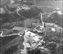
1958
Comments
Not RADAR but VDF
The small hut was a VDF (Very High Frequency Direction Finding station) as evidenced by the antennae at the four cardinal points. Inbound aircraft would transmit a request for a bearing to or from the station to enable them to make a non-precision approach to an airfield in non visual conditions. Hence the requirement for staff to be present on a shift basis to answer these requests which they read from a scale around a screen
Those antennae would normally be positioned atop an airfield’s control tower. Kai Tak’s location however made this impractical for various reasons, but by putting it up on Mt Kellett the elevation enabled the service to be provided to aircraft well out into the South China Sea. Remember that adjoining airspace was not always friendly in those days and pilots were often unsure of their exact position after long overwater crossings
Looking at Google Earth the hut is still there but now sits on a circular concrete base of about 40 ft diameter. This I believe was what a later more precise and user friendly VOR (Very high Frequency Omnidirectional Radio beacon) was constructed on. It’s radio identification was MKT but in the mid ‘70s was itself superseded by the current CH VOR on Cheung Chau
Thanks. Based on the above…
Thanks. Based on the above comment, and similar ones at https://gwulo.com/media/26396, I've changed the title of this "place" from Radar Station to VHF Transmitter Hut/VDF.
Current Condition
This "place" refers to the small, white hut which, in 1958, stood on the site previously occupied by the Eyrie's Belvedere. Recent photos show the site is still occupied by a smallish, white hut, but I'm not confident to say it's the original. If anything, the current hut looks a bit bigger, but I'm not sure. Hence, I've put "unknown" for "current condition" of the 1958 hut.