Everything tagged: Tai Hang

Photos tagged: Tai Hang

c.1901
1915
1915

Pages tagged: Tai Hang

Ma Shan Squatter Village [1950- ]

Submitted by EthanCK on

Ma Shan Squatter Village (馬山寮屋區) is a squatter village located in Tai Hang, present-day north of Lai Tak Tsuen. It was completed in the early 1950s where locals and immigrants settled in because of the devastating WW2 that left many people homeless. 

In 1971, the government planned to construct a road connecting the newly built Lai Tak Tsuen to Tin Hau Temple Road, so about 500 residents along the route were resettled to Hing Wah Estate, the road was named Yee King Road.

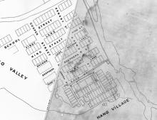
Back Street [1901-????]

Submitted by EthanCK on

Named after: The back of the newly built village of Tai Hang 

Chinese name: 後街

Timeline

  • 190?: Street first laid out
  • 190?: Street named
  • 1901: First map depicting Back Street
  • 19??: Street name replaced by Sun Chun Street
  • 1959: First map depicting Sun Chun Street

Other points of interest:
16 Sun Chun Street, THL 40

Cooper Street / Brown Street [1901- ]

Submitted by EthanCK on

Named after
Francis Alfred Cooper (First Director of Public Works 1891–1897)
Samuel Brown (Surveyor General 1889–1891) 

Chinese names:
谷柏街 
寶琅街
布朗街

Italic words mean name used before.

Timeline

Tai Hang Market (2 Wun Sha Street) [1928-1959]

Submitted by EthanCK on

A single story brick building on top of Tai Hang Nullah, it was demolished alongside the covering of that nullah. It was built out of red bricks to be specific. 

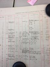
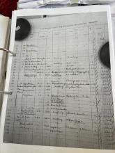
Page 3, Hong Kong Daily Press 1914-02-25, the Sanitary Board agreed to erect a temporary market of 12 stalls, and reserve a site for a permanent market. 

At 1927 September 23, the government gazetted a tender for reconstruction of Tai Hang Market.
It has a chance to be built on the reserved site in 1914.

Wun Sha Street [????- ]

Submitted by Admin on

This used to have an open nullah running along the centre of the street. The nullah is still there, but now it is covered over and out of sight.

57-63 Wun Sha Street [c.1955-c.1988]

Submitted by Klaus on

4-storey buildings at 57-63 Wun Sha Street.

Wun Sha Street has been constructed along the former Haw Par Stream/Victoria Park Nullah in the early 1950s. 57-63 Wun Sha Street were the oldest houses built in the uphill direction. The construction date is unclear, they were built earlier than the Concord Villas which were first occupied in June 1958. So 1955 is the estimated construction date.

They were demolished around 1987/88 and replaced by the Fook Hing Court (first occupied May 1989).

Secret Valley between Tai Hang and Quarry (Eod Depot)

Submitted by MikeB on

As an avid hiker I stumbled on a trail that leads from Mount Butler Road down to the valley creek which runs in a South Western direction from Tiger Balm to the quarry by Jardine's lookout. 

There's a myriad of terraces, relicts, overgrown trails, stairs, which seem to have not been visited for decades. Even the trails from Various map sources were

very hard to find if not existing anymore. We def ended crashing through the undergrowth to reach the creek which wasnt without danger.