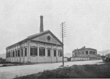
Hung Hom Dockyard Headquarters [c.1888-c.1945]
House/Office on Point at Hung Hom Dockyard
The house existed into the 1930s, I assume it was either destroyed during the war or by dockyard expansion in the 1930s. I can find no trace of it post WW2
House/Office on Point at Hung Hom Dockyard
The house existed into the 1930s, I assume it was either destroyed during the war or by dockyard expansion in the 1930s. I can find no trace of it post WW2
Temporary station on Chatham Road which opened with the start of the KCR in 1910. The Kowloon-Canton Railway Report for 1910 refers:
At Hung Hom a wooden structure has been constructed which will serve well enough until such time as events necessitate the building of a terminal station.
A photo of the station can be seen here.
Second generation Hung Hom Police Station was located at the junction Chatham Road North and Hok Yuen Street. It can be located on the 1956 Kowloon map on Gwulo.
Simtang pointed out that works for the police station building commenced in 1949, and the station was opened in 1950. The station was demolished when Chatham Road was widened; it is still there on an aerial photo from December 1977, and gone on one from September 1979.
Adjacent to JDH Centre, should be demolished at the same time with JDH Centre.
(Timeline added, based on the comments below:)
1963 - The pier opens for business. Initially it handles the Hung Hom - North Point ferry service that moved here from the pier off Gillies Avenue.
1975 - The Hung Hom - Wanchai ferry service also moved here. That service previously ran from the adjacent pier, slightly southwest of this one.
(Timeline added, based on the comments below:)
1965: The pier opens for business in June. It handles the Star Ferry's Hung Hom - Central ferry service.
1967: The Star Ferry suspended their Hung Hom - Central service, owing to the riots. No other ferry service used the pier after this time.
c.1971: Aerial photos of this area show the pier was demolished in around 1971.
(Timeline added, based on the comments below:)
1963: The pier opens for business. Initially it handles the Hung Hom - Wanchai ferry service operated by HYF (The Hongkong and Yaumati Ferry Company Limited).
1975: HYF moves the Hung Hom - Wanchai ferry service to their other pier, a short distance northeast of this one. Star Ferry then rent this pier from HYF, to use for the Star Ferry's Hung Hom - Central ferry service.
Hi there,
I spotted this last night. Unfortunately the stone had already been weathered down. I was unable to read the engraving. It could be a K.I.L. or a H.H.I.L. I will return for a second visit in daylight later.
The same alley is the one with pillars on both ends that have mentioned before. If you check up the street map of the location, you should be able to see the same alley continues on the other side of Ma Tau Wai Road straight to Gilles Avenue South and beyond.
Best Regards,
T
Hi there,
After bumping into the K.I.L. Markers on Ma Tau Wai Road I decided to take a look in the neighbourhood for houses being built more or less in the same period and indeed, I found another set of H.H.I.L Markers on the first step of another staircase in Wuhu Street.
