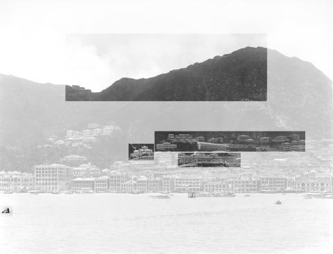
Last time we looked at this photo we concentrated on the buildings along the seafront, using them to date the photo to 1895. Before we leave this photo, there are a few more areas I'd like to put under the magnifying glass.
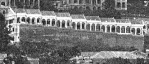
Central Police Station Compound
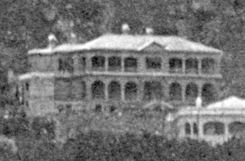
Moving inland from the seafront, here's the first one:
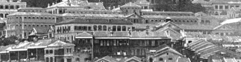
Here's a highlighted copy to make it easier to see the different buildings.
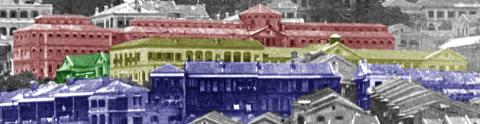
The buildings tinted blue are private buildings along the north side of Wyndham Street on the left, and Hollywood Road on the right, so they're outside the compound. The gap between the buildings marks where Pottinger Street runs between them.
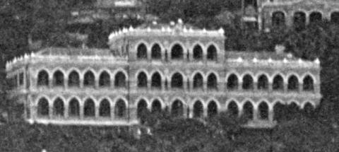
The rest of the highlighted buildings are within the compound:
- Yellow: These are two police buildings, the Married Inspectors' Quarters on the left, and the Barracks Block on the right. Both are still with us today, though if you visit them at Tai Kwun you'll notice the Barracks Block looks taller, as a fourth floor was added in 1906.
- Green: The Central Magistracy. This was the previous generation of magistracy to the current building.
- Red: The prison halls, with the central tower of the old radial design clear to see.
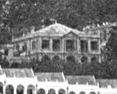
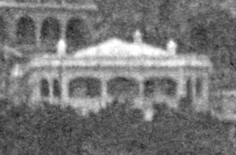
Roman Catholic Cathedral
In the recent newsletter looking at the old photo of Caine Road I wrote:
The Roman Catholic Cathedral is immediately behind the buildings in this photo. It's an impressive building that is well worth a visit - many people don't know it is there, as it has been surrounded by high-rise buildings that hide it from view.
Back in 1895 it was still clearly visible from the harbour:
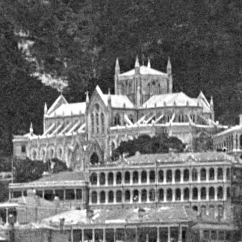
In this photo it's about seven years old, having opened in 1888 to replace Hong Kong's first Roman Catholic Cathedral that was down on Wellington Street.
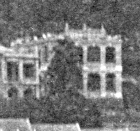
Upper mid-levels
Looking up from the cathedral, we can see the buildings along Robinson Road. In 1895 they formed the upper limit of the mid-levels area.
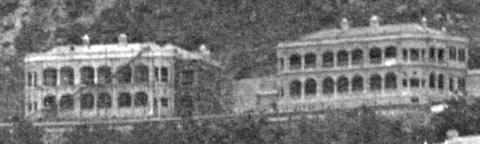
A. St Joseph's College / St Joseph's Building [1882-1988]
The school was part of a cluster of buildings in this area that were connected to the Roman Catholic Church.
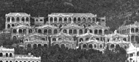
Though this whole area was called 'Belilios Terrace', an 1897 map shows there were actually four terraces rising up the hill, with a total of 15 different buildings.
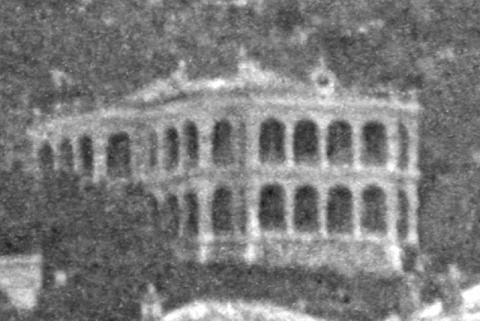
C. Rocklands
This is the first of the string of mansions that stood above Robinson Road. They were mostly set in large lots of land that were bounded by Robinson Road on the downhill (north) side, and the freshwater conduit on the uphill (south) side. Later a road would be laid over the conduit, giving us today's Conduit Road.
The new Conduit Road gave easy access to the uphill sections of the lots, encouraging landowners to build new houses there. If we look at a modern map of this area the outlines of the original lots are still clear to see, but now they usually house several buildings, some on the lower half along Robinson Road, others along Conduit Road on the upper half, and sometimes extra buildings in the middle!
As an example, back in 1895 Rocklands occupied all of this piece of land, Inland Lot 713. Today that lot is home to:
- Three smaller buildings fronting Robinson Road, numbers 27D, 27E, and 27F.
- A larger building 'Jing Tai Garden' in the centre, occupying the bulk of the lot.
- Block B of Tycoon Court, up on Conduit Road.
Mosque Street slopes downhill from its junction with Robinson Road. The photo shows a terrace of nine buildings on the downhill side of Mosque Street, overlooking the Italian Convent. Their bright white colour makes them stand out, and suggests they were newly built when this photo was taken.
It looks as though they are each just a single-storey high, built on top of a high retaining wall. But if you look at the left edge of the terrace it looks though it had three storeys. Then did the other buildings in the terrace also have multiple levels? (Also, I wonder if any part of that large retaining wall still survives?)
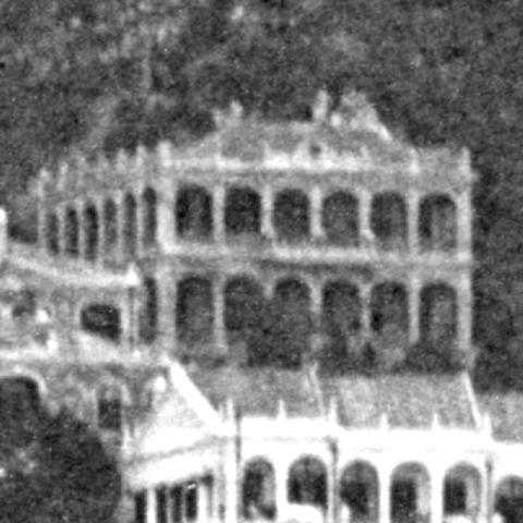
E. Benfica
Back to the mansions - on the 1897 map Benfica was number 5, Robinson Road. Like many of Hong Kong's roads, Robinson Road has been re-numbered over the years. The building standing here today, Right Mansion, is number 29.
G. Garden Lodge
Garden Lodge is a much smaller building, breaking up the line of mansions. The map shows it couldn't have been much larger, as it stands on a lot that is much shorter and narrower than its neighbours. You can get a good idea of the shape of the lot from the current buildings on the lot, numbers 33 and 35 Robinson Road.
According to the 1897 map, there should be a larger building named Eureka to the right of Garden Lodge. I can't see it clearly in the photo, so I think it must have been a low-rise building, hidden behind the trees.
H. Sans Souci
This was built at the top of the lot, so did they already know that Conduit Road was going to be built? The comments on the page for Sans Souci show that several residents had interesting histories.
J & K. Elliott Crescent
I see building J on the left is still under scaffolding, suggesting it may be just finished being built.
The naming of the three buildings I, J, and K is still not 100% clear to me:
- On an 1897 map, the three buildings are shown together, with the label Elliott Crescent.
- On the 1901 map below, building I is labelled Elliott Bungalow, while the "Elliott Crescent" label is just over Buildings J and K.

L. Strathallen
Strathallen survived until at least 1979, when this photo was taken:

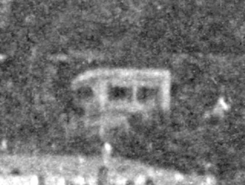
The Peak
The Peak Tram had opened in 1888, making travel to and from the Peak much easier, and triggering a wave of house-building there. We've looked at enough buildings already, but there are several other structures that are worth a closer look.
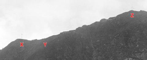
At position X there's a flat piece of land with a fence around it, and a flagpole in the middle.
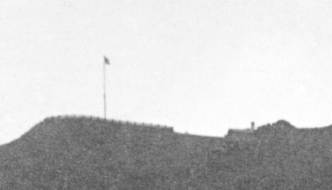
They belonged to the Mount Austin Hotel - we can see a small part of the hotel's roof and one of its chimneys down in the dip to the right. We can get a better view of them from the other side of the ridge.

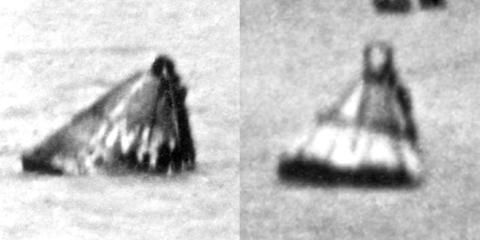
A bit to the right at Y there's a dot on the skyline - another chimney perhaps?
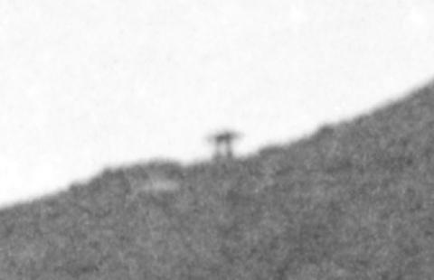
Under the magnifying glass we can see the dot splits into two separate vertical lines, with a flat bar across the top. That shape identifies it as the Umbrella Seat. Again, the view from the other direction is clearer:

It is a good spot to rest and admire the view if you are walking up to the top of the Peak - there is still a seat with a shelter at this location today.
Over at the right, marked Z, is another flagpole.
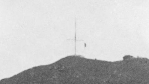
This one belonged to the Signal Station, and its prominent location reflects its importance to Hong Kong's residents.
In those days of much slower communications, the arrival of the mail steamer was an important event. The Signal Station kept a lookout for ships sailing towards Hong Kong. If the arriving ship was a mail steamer the Signal Station's staff would fire a gun to let Hong Kong's residents know, and raise a special signal that would let them know which country the mail steamer was from. Different signals identified other ships that were approaching Hong Kong.
")
The Harbour
We'll finish off in the photo's foreground, where I noticed a couple of large buoys. The one on the left has markings on - can any readers explain their significance?
Further reading
If you've got Volume 3 of my books, please take a look at Photo 2 on pages 8 & 9. It shows Hong Kong from a similar viewpoint, but 11 years later in 1906. Hong Kong is forever changing, so looking at the book's photo you'll see:
- The Roman Catholic Cathedral has gained a large new bell tower.
- Mid-levels looks very different. In the main photo above, it looks as though all the land at the top of Mid-levels that was flat enough to build on had already been used. But by 1906 a whole new row of buildings had been squeezed in above the new Conduit Road.
You might also enjoy the previous newsletter about this photo, where I took a closer look at the buildings along the seafront.
Gwulo Photo ID: A655
As always, please leave a comment below if you spot any mistakes, or if you can add any information.
Comments
The terraced villas along Mosque Street
@"It looks as though they are each just a single-storey high, built on top of a high retaining wall. But if you look at the left edge of the terrace it looks though it had three storeys. Then did the other buildings in the terrace also have multiple levels?
Since you ask the question, David, I suggest YES!
If you take into consideration the sloped street and the relative position of the ground-floor level of the lowest block, the conclusion would be that this building and all the others along the terrace would have been of similar height with three storeys.
re: The terraced villas along Mosque Street
The reason I wasn't sure is that if that is a solid retaining wall, the lower two storeys of the middle buildings would be underground, without any light or ventilation. But if they are just a single storey high, that would make them small buildings which doesn't seem likely either.
I'm hoping we'll hear from someone who has seen the buildings when they were still standing and can tell us about their layout.
I too have no idea what the…
I too have no idea what the answer is but it looks like the row of buildings are genuinely 3 storeys high throughout and that there is a gap between the buildings and the wall. But if that is the case, why is there a wall blocking the lower two storeys of a fantastic view of the harbour? Was the wall a ‘left-over’ from a previous architectural incarnation and this photo captured a precise moment in time in which the buildings were built but before the wall was subsequently knocked down?
Chinese?
Any Chinese, non-servant, reside in this neighborhood?
1910s Robinson Road View
Was the wall a ‘left-over’
Here's a comparison of the 1895 view with a later view from 1906. The wall was there to stay!
re: Chinese?
The Jurors Lists can help answer your question:
Here is a view of the…
Here is a view of the buildings from the side (mid left of picture), unfortunately the wall is not shown.
I had looked into this wall a while back, and while I could find no hard evidence, the conclusion I came to was that the wall was a 'modesty wall'. The land these houses were built on (I.L. 58 - a 999 year lease granted 1 September 1857) overlooked the Italian convent and I assume the nuns were none too pleased with the prospect of a bunch of randy bachelors looking down upon the convent hence the wall was constructed. Its possible the land was originally owned by the convent or some other Catholic religious body - it is a very low lot number - I'm sure there was a prior lease before 1857.
Unfortunately the construction of the SHCC buildings in the mid 1900s meant that the wall could no longer been seen in photos taken from the harbour but it seems the building survived until the mid 1950s or so its possible the wall did too
Modesty wall
Thanks Herostratus, not sure if we'll find any document to confirm that, but it certainly makes sense.