The heavy Japanese dive-bombing of Wanchai Gap and Magazine Gap in Hong Kong took place on December 23, 1941, at around 1330 hours
- Context: Japanese ground forces reached the area and launched heavy air and ground attacks, as documented in historical accounts like Not the Slightest Chance (Tony Banham).
=============
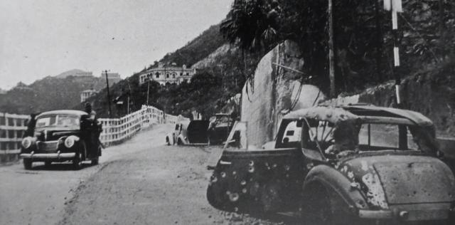
Sapper Hyndman was injured by Japanese airplanes strafing when he was returning home to the Grenville House, 3 Magazine Gap Road by a military staff car, on 23th December 1941. His car was in the photo with the trunk opened (photo was taken around 28Dec by the Japanese). He was rushed to the War Memorial Hospital in the Peak, and die on 31 December 1941.
source
Date picture taken
1941 (year is approximate)
Shows place(s)
Shows event(s)
Comments
Craigmin (East and West)
Thanks for posting this dramatic photo which really helps bring to life the events that took place around this location as described by Charles Barman in "Resist To The End" and discussed at https://gwulo.com/node/57368 .
Is that a Japanese soldier on the running board of the approaching car?
I'm fairly confident the nearest building is Craigmin (East & West). Which means that the foreground of this photo must be very close to the junction with Barker and Guilford Roads.
The house further away, partly hidden behind the sloping ridgeline, would be either No.499 or No.501 The Peak. I'm unsure which one it is, so haven't linked either "place" to this pic.
On the ridgeline in the distance are Cheltondale and Slemish.
Apologies for being pedantic, but I think this was called Stubbs Road in December 1941.
Peak Road
I believe GW is strongly hinting that this isn't Magazine Gap Road at all but today's Peak Road near the junction with Guildford Road/Barker Road. Hence why he mentions Craigmin and that, at this time, the road was still named Stubb's Road (the road name was changed to Peak Road circa 1960).
Craigmin East and West - 505,506 Craigmin Road
According to Gwulo, Craigmin East and West, are located at 505, 506 Craigmin Road.
https://gwulo.com/node/34922
Assuming the house at centre of photo was The Firs (later on Grenville house) at 3 Magazine Gap Road, it was unlikely you can view Craigmin East and West from there.
HYNDMAN, EDWARD FILOMENO
After I traced this photo's origin from Sohu, it end up back to Gwulo !
https://gwulo.com/node/15247
Name: HYNDMAN, EDWARD FILOMENO
Nationality: United Kingdom
Rank: Sapper
Regiment/Service: Hong Kong Volunteer Defence Corps
Age: 17 Date of Death: 31/12/1941
Service No: 5002
Casualty Type: Commonwealth War Dead Grave/Memorial Reference: 5. A. 8. Cemetery: STANLEY MILITARY CEMETERY
Sapper Hyndman was injured by Japanese airplanes strafing when he was returning home to the Grenville House at number 3 Magazine Gap Road by car, on 20th December 1941. His car was in the photo (not sure when the photo was taken, very likely taken by the Japanese).
He was rushed to the War Memorial Hospital in the Peak, and die on 31 December 1941.
Origin of Photo
Just a note. I had seen the main photo in http://www.hongkongwardiary.com/ a few years ago in its monthly newsletter. But I cannot find the reference link now and the write-up. The photo may have appeared around the same time as this link:https://www.toutiao.com/article/6805584430405517827/?wid=1785274914519
Peak Road
I've been trying all the angles with this image and can't really reconcile this as being a shot of Magazine Gap Road looking east. The bigger version of the image (see here) clearly shows the steep side of the peak on the right hand side, with another property above the bushes, which aligns with this being the south side of the ridge. Craigmin East matches perfectly the building seen centre screen with the same shape and number of window apertures as well as the distinctive moudling pattern on the window lintels. The general topography of the view very much matches the current view of the area mentioned by GW in his first post above.
Could this be another case of a long time misidentification? i.e. People see "Magazine Gap" and assume it refers to the road itself, whereas this shows former Stubbs Road near to the gap.
Comparison of photo with map
Apologies if I didn't make myself clear earlier and thanks to Phil for correctly interpreting what I was trying to say.
The following is a comparison of the photo and the OS map of the area between Magazine Gap and Mount Kellett in the early 1950's.
The red line on the photo is the line of sight from the camera to the distant peak, and is reproduced on the map. The numbers represent the following;
The peak of Mount Kellett.
So the camera was on Stubbs Road (today called Peak Road) somewhere near Magazine Gap and close to the junction with Barker Road.
HYNDMAN, EDWARD FILOMENO - SCMP 1946
On December 23, he was fatally wounded with a piece of sharpnel that tore through his back and was embedded in the spine. From Bowen Road, where this occurred, he was carried on the shoulders of his mates to one hospital and another, when every.......
HYNDMAN, EDWARD FILOMENO - La Salle Old Boys' Newsletter 2010
HYNDMAN, EDWARD FILOMENO, a student of LSC, and who lied about his age so that he could join VDC in defence of HK.
The car he was travelling in was hit by a Japanese Bomb on 20 December near Magazine Gap Road, and after being mortally injured, he died of his wounds on 31 December 1941.
HYNDMAN, EDWARD FILOMENO - Gwulo
On the 20th December, George, his Chinese driver, in the front seats and Eddie, safely in the back seat of their Staff car, made their way under fire from Japanese planes to the Peak.
When they arrived at Magazine Gap Road they received heavy strafing from one of the planes, followed by a bomb which hit the back of the Staff car. George and the driver were blown free of the car and landed on the road, unhurt but poor Eddie was not so lucky. He received severe injuries and was rushed to the War Memorial Hospital in the Peak.
Stubbs Road/Peak Road
As explained in the comments above, the image quite clearly shows the (then) Stubbs Road (now Peak Road), so it seems that one of several things may have happened here:
- It is an image of Eddie's car (I have yet to see proof it is other than online references which may or may not be accurate) and the original reports reported the location incorrectly, either through the fog of war, or at some point "near Magazine Gap/Magazine Gap Road" has been conflated with "on Magazine Gap Road".
- It isn't an image of Eddie's car and is just an image of probably one of many cars that were damaged or destroyed during the invasion but has been used as an illustration of the event at some point and the association has stuck and been subsequently repeated.
Please look into the following
page created by David, and click into the hyperlink will lead into the following photo (page 4 of the hyperlink), I have no preference of where the photo location should be, the evidences from the SCMP, Gwulo, La Sally Old Boys' Newsletter pointed to the Magazine Gap, may be they were all wrong ?
https://gwulo.com/node/15247
Magazine Gap versus Magazine Gap Road
I think there were some confusion on Magazine Gap 馬己仙峽, a Mountain pass, mistaken it as Magazine Gap Road, one way or another.
==========
https://gwulo.com/node/18740
The Military Sanitarium at Magazine Gap was a 19th-century colonial health and recovery outpost built in 1883 on Hong Kong Peak. It served as a high-elevation respite for British military personnel, though the location was later noted to be malaria-prone and was phased out around 1923.
Historical Overview
•Establishment: Built in 1883 to give sick or recovering soldiers cooler mountain air.
•Location: Situated near Magazine Gap on The Peak, on terrain later used for the Mansfield Road Government Quarters.
•Decline: Closed and dismantled around 1923 after medical reports highlighted persistent local health and mosquito issues.
•Defense Role: The strategic high ground near the old sanitarium later held mobile artillery positions during the Battle of Hong Kong in 1941.
WO 172/1687 War Diary Island East Group RA.
19th Dec. Mobile Artillery at dawn: 6” Howitzer x 2. Sanitarium.
At surrender: 4.5” Howitzer x 2. (1 OOA). That’s army speak for out of action for some reason. This document does have some conflicting details with guns and places in other areas, but those seem pretty specific.
Main Photo and Hyndman
The location of the main photo has already been addressed by gw and philk.
Regarding Hyndman, the SCMP article dated 1946 (earliest reference) mentioned Bowen Road as the location of where Hyndman received his injuries. If the location of Bowen Road was correct, it would mean the accident location was further down the Peak and not consistent with the location of the main photo.
It would appear that references to Magazine Gap or Magazine Gap Road as being the scene of the accident came later from other sources.
With reference to the scene of the accident, I note the website for Hyndman mentioned "When they arrived at Magazine Gap Road" - would this mean the junction of Bowen Road and Magazine Gap Road ?
On page 6 of Eddie HYNDMAN's website
From the records of Fred & Teresa Hyndman.
Had it not been for Fred and his wife Teresa, this account may never have come to light.
After receiving an email from Fred, I remembered my father pointing out to us where his car had been strafed and where he and his driver ended up. He did not go into detail.
Fred's words were :
My father found out from the hospital that when Eddie died, the Chief Surgeon sadly remarked that "This is a sad day
for us. The youngest volunteer in the H.K. Defense Force has died!"
Dear Master Moddsey, yes i…
"would this mean the junction of Bowen Road and Magazine Gap Road ?"
Dear Master Moddsey, yes i think so, but should we trust the news 100%.....and SCMP said Eddie past away in the Queen Mary Hospital, this contradict with the other source, which was the War Memorial Hospital in the Peak.
Re: Discrepancy
I did note the conflicting information regarding Hyndman’s death.
Normally primary sources of information like the SCMP (although 5 years later) should be trusted and reliable unless proven otherwise.
That said, an independent look of information regarding Hyndman’s demise in December 1941 is available on the Club Lusitano website: https://www.clublusitano.com/post/the-portuguese-community-in-the-volunteers-and-defence-ofhong-kong-80-years-after-liberation-part
A 1941 military staff car…
A 1941 military staff car typically refers to light "soft-skin" vehicles like the Ford WOA1 or Dodge Command Car used by Allied and Axis forces during WW2.
Dive Bombing on Magazine Gap 23Dec41
Dive Bombing on Magazine Gap 23Dec41
This photo taken by a Japanese pilot probably on a Japanese Army Air Force Nakajima Ki-27 Fighter Bomber, launched from Guangzhou or Zhuhai airport on that day, before and during the dive bombing on Magazine Gap 23Dec41.
After bombs hit several location on Magazine Gap at 16:30, the main underground telephone cables were damaged.
This cut 195 circuits and broke all wired communication between Fortress Headquarters and military positions south of the gap, severely disrupting the British defense.
Main lines between command and southern sectors went dead. Commanders could not issue coordinated orders by phone.
There were increased confusion and runners had to carry messages by hand during heavy attacks.
https://gwulo.com/media/20401
https://gwulo.com/node/18919/view-pages