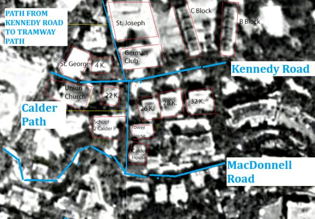
Source: 1924 aerial photograph on hkmaps.hk.
In this photo, the streets are marked in blue, and the buildings have a red frame. The photo is slightly enhanced, but still a bit blurry. Nevertheless, a lot of information can be extracted from it.
On the northern side of Kennedy Road, we see St. George's House, 4 Kennedy Road, the German Club with St. Joseph’s College behind, and then C Block and B Block of Victoria Barracks.
The buildings on the southern side of Kennedy Road start with Union Church, followed by 22 Kennedy Road. The latter building likely is “The Manse” (it still bears that name in the 1938 street index). Next is Calder Path, followed by three buildings (26, 28 and 32 (possibly 30-32) Kennedy Road). All three buildings do not stand directly on Kennedy Road but are a bit retracted. Likely they have a retaining wall at Kennedy Road, and on the platform is a garden, followed by the buildings.
The 1938 street index lists only two buildings on Calder Path: 2 Calder Path on the western side (no name given on IL 1937 and 1219), and 1 Calder Path (Tower House on IL 1380) on the eastern side. Calder House (the name appears on the 1901 map on Gwulo) is listed as 35 MacDonnell Road (1938 street index).
This means that although only two buildings have house numbers on Calder Path, we see two buildings on the western and three buildings on the eastern side.