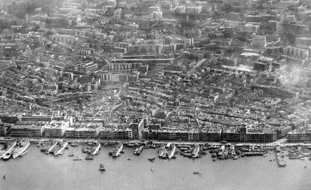
An early aerial photo of Sheung Wan. On the waterfront in the centre is Western Market and the Empress Hotel. Please add in the names of any of the piers or buildings under place locations.
Date picture taken
1927
Gallery
Shows place(s)
Comments
piers and places
Moddsey, very nice find. On the very left hand side, a bit of the Harbour Office is visible. The next pier to the right should be the Hong Kong Macau Ferry Wharf (second generation). In front of the Western Market should be the Morrison Street / Connaught Road Pier for ferries to Mong Kok & Sham Shui Po. Next to the right should be Public Pier No. 17 - British Canton Line / Yuen On Steamship Co. Ltd. Finally on the right where the tram leaves the praya is Wing Lok / 三角 Pier.
Still a couple of piers to be identified.
Pasig Wharf
I note in some of the maps seen in http://www.hkmaps.hk/mapviewer.html that the wharf immediately to the west and next to the Hong Kong-Macau Ferry Wharf is known as the "Pasig Wharf". Probably named after the river steamer "Pasig" that operated the Hong Kong to Canton service.
Piers
We see 9 piers on this aerial photograph. From left (east) to the right (west) there are (8 of the 9 names are from the 1945 map on Gwulo)
1 Hong Kong Macau Ferry Wharf (second generation) [1900-c.1958]
2 Tung On Wharf
3 Po Tak Wharf (Pasig Wharf on the 1924 map)
4 Ping On Wharf
5 Morrison Street / Connaught Road Pier for ferries to Mong Kok & Sham Shui Po [????-????]
6 Public Pier No. 17 - British Canton Line / Yuen On Steamship Co. Ltd [????-????]
7 Hoi On Wharf
8 Yueng Tai Hing Wharf
9 Macao Wharf (Wing Lok / 三角 Pier [????-????])
Pasig Wharf
moddsey, I took your reference to Pasig Wharf (didn't know is was a steamer) and created a place for it.
piers
Klaus
This is brilliant work you are doing on all the piers and consolidating the various nodes. It's quite an education to see a former nondescript place suddenly have a name and decent history behind them. Phil
Great Work
Well Done!
Her's the photo with
Here's the photo with annotations.
The tall building at the
The tall building at the right of the photo is the eight-storey Tung Shan Hotel.