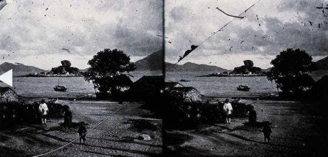
Kowloon Wan shoreline in about mid-1800s. The ridge line of the distant hills matches well with the current photos looking to the southeast from To Kwa Wan. This could be the original shore which is of personal interest for its farmland and tranquility, and of course the huge lonely boulder on the tiny island.
I don't think this was the Sun Wong Toi rock which sits on land connected to the mainland and its shape is different. I wonder.
In the 1922 (long after this photo) Public Works Department Annual Report - https://gwulo.com/node/19769 - it reads "The following is a statement of the private reclamations which were completed or in progress during the year: - ... To Kwa Wan (completed)..... In addition to the above, some further progress was made in connection with the work of reclamining about 215 acres of fore-shore and sea-bed at the head of Kowloon Bay, referred to in previous years' Reports". It is not clear if it referred to the land in this photo, but reclamations dated back a long time and I believe will continue.
The report continues ..."The areas stated are those of the lots, which in some cases extend further inland than old high water mark and are there-fore not exclusively reclaimed from the sea." Putting the issue of climate change aside, I am curious about the term "old" high water mark; as high water mark is derived from recorded sea tides for a specific period of time. It could be some grandfather clause issued at the time of awarding the lot(s), or a new vertical datum adopted later to measure and publish sea tides.
Nice to see those hyphenated words from the good old days.
Photo source: uwants.com - post #1904 by Is1970 - http://www.uwants.com/viewthread.php?tid=14833421&page=127#pid213230265
Comments
To Kwa Wan Island aka Fish Tail Rock
That is To Kwa Wan Island, today's Hoi Sham Park. See here
To Kwa Wan Island
Thanks moddsey for waking me up from New Year's Eve. I didn't drink to celebrate, but obvious was not observant when I looked at the other photos. Regards, Peter
"old high water mark"
I take this to mean the high water mark of the original coast, before reclamation pushed the shoreline out.
Regards, David
PS I've changed the Places Shown from Sung Wong Toi Garden to To Kwa Wan Island.
Old High Water Mark
Thanks David. I have the same impression. Regards, Peter
The photo is by John Thomson…
The photo is by John Thomson, dated c. 1870 (he lived in Hong Kong from 1868-1872). see here.