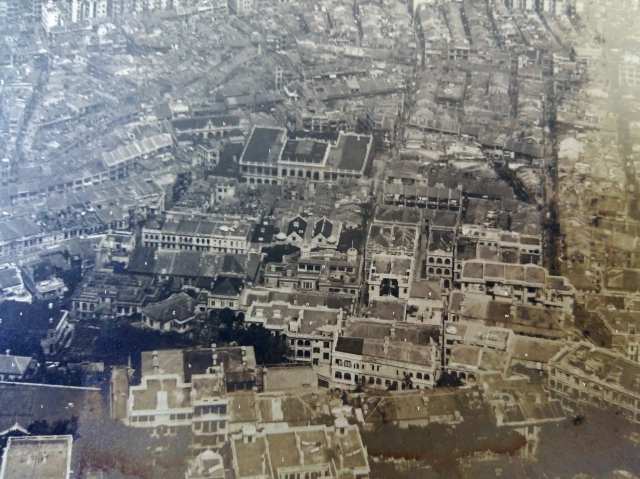
Photo taken in the 1920s from the Peak showing Mid Levels. Caine Road runs horizontally across the picture. Robin Road at the Bottom.
a The Castle
b The Den
c Jewish Recreation Club
d Dinder Successor Building
e West Terrace
f Upper West Terrace building - also partle on site of Wilderness
g Building appears on 1901 Map - is it connected to the Pentercostal Tabernacle?
h Seymour Terrace Lower Block
i Seymour Terrace West Block
-the two units at the western end have been demolished, 3 remain
j Building at today's 63-67 Robinson Road
k Bellios Public School for Girls
l Queens College
m Buxey Lodge
n Kom Tong Hall
o Upper Woodlands Terrace
p Building that replaced Woodlands Villa
q Half of Lower Castle Terrace
r Upper Castle Terrace
s Terraced Houses that replaced Belmont
t Seymour Terrace East Block
-The most easterly unit has been demolished and a large house has replaced it
u Boulder Lodge
v Lower Mosque Terrace Building - original building demolished
w Middle Mosque Terrace - original building (address was Lower Mosqque Terrace)
x Upper Mosque Terrace
y Unknown building at top of Peel Street and Seymour Road
z Douglas Villa