Part of a collection of pictures made by Jim Watkins (deceased) of Henley In Arden, England while on military service in Hong Kong probably1947.
Date picture taken
30 Jun 1947
Gallery
Shows place(s)
Comments
The building on the corner of
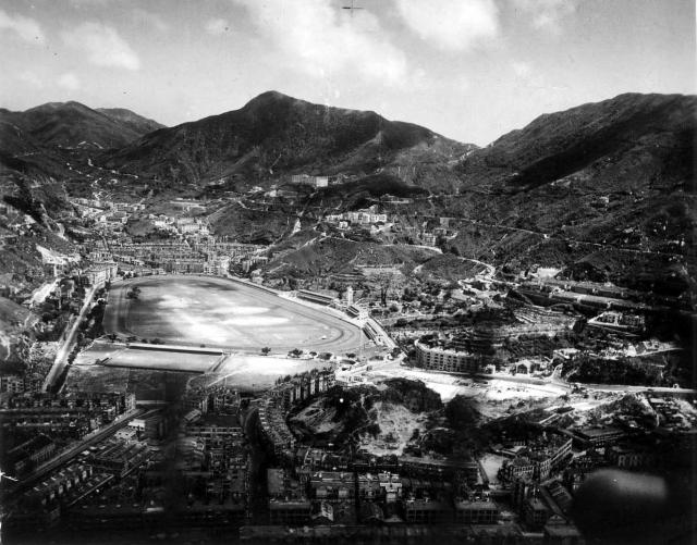
The building on the corner of Queen's Road was bombed during the war, you can see the right end is damaged in comparison with this pre-war view:
Right from that is the Sikh temple. It was also damaged by bombing. though it looks to have been rebuilt by the time this photo was taken.
Right again we can see part of a square building below Stubbs road. Possibly the elusive Lane Crawford Bakery? (https://gwulo.com/node/13908)
Re: Lane Crawford Bakery
The building may either be the Bakery or the HK Hotel Garage as shown here
The garage is described as a
The garage is described as a large, three-storey building, so that sounds a better match for the building in this photo.
Regards, David
Re: Shiu Fai Terrace & Tung Shan Terrace, et al
Hi there,
Some observations:
T
Between Shiu Fai Terrace and Tung Shan Terrace on Stubbs Rd
More closer to TST, there are a group of three buildings which, by pro-war time, was the Lingnan Primary & Middle School. During the 1960s, three more buildings were being added to expand the school capacity as there was plan preparing to form an university by its oversea directors.
Tung
HK Sanatorium
To add one more to T's list:
HK Sanatorium on Wong Nai Chung Road.
Gap Road School
Not sure if the small building next to the Sikh Temple is the captioned school.
Re: Building right next to the Sikh Temple
Hi There,
From this photo it seem there was nothing there. If it was dated around 1947, it might have shown the already destroyed school with the big and unexploded bomb under the rubbles until they found it last time.
T
Here's a comparison of the
Here's a comparison of the area before (upper) and after (lower) the war:
Before the war the main building had five stairwells along Gap Road, numbered 1-5 in the upper, c.1940 photo.
After the war the right stairwell, number 5, is gone and replaced by a smaller structure. I guess that the bomb that landed in this area severely damaged the western end of that building (5), the Gap Road School (6) and the 2nd-generation Sikh Temple (7), which led to them all having been demolished by the time the lower, c. 1947 photo was taken.
lingnan school
The photo was taken in 1947. Lingnan primary was there already before the war. And middle school was added after the war. The school should be on Stubbs road which is the first road along the hillside above the Happy Valley race course. Further uphill is the Bowen Road. As tung lin mentioned there were three buildings at that time. One on Stubbs road. Two behind it further uphill. There is a whole stretch of empty hillside on the right until some buildings appear at Siu Fai terrace near the edge of the picture.
Sikh Temple
I would like to know if there are more photos of the Sikh Temples and the Sikh police from 1900 onwards