This walk is one of my favourites. On the map there doesn't seem to be much to see, but on the ground there's all sorts - Bruce Lee's ancestors, 1950's squatter villages, and even a so-called ‘concentration camp’. The walk takes you out of the built-up areas too, so it makes a pleasant break if you’re starting to find Hong Kong a bit claustrophobic.
| Starting point: Pokfield Rd bus terminus on Pok Fu Lam Road, Hong kong island. Getting there: Bus 23 terminates there, so is the easiest bus to take. You can get on board in Causeway Bay, Wanchai, or outside Pacific Place in Admiralty. Other buses that stop here include 4, 7, 37A, 40, 40M, 90B, 91, 970, and 973. You’ll recognize the stop by the two gas stations nearby (see photo). If you prefer to catch a taxi, you might want to print the name in Chinese to show the driver. How long: If you walk at a brisk pace without stopping, you can finish the walk in an hour. Allow 2-3 hours for a walk at a slower pace with stops. Difficulty: The route is paved throughout. There are a couple of hills to climb, but these can be avoided if necessary. |
From the Pokfield Road bus stop, walk up Pok Fu Lam Rd. You’ll be on the left side of the road, heading up a gentle hill. Don’t be surprised if you see a lot of young people and westerners along here, as several of the buildings you’ll pass are halls of residence for the nearby University of Hong Kong.
After a couple of minutes you’ll pass the Fulham Garden residential block on your left, and see the start of railings along the edge of the road. As you reach the start of the railings look ahead to your left and you’ll see a granite marker stone, inscribed with ‘City Boundary 1903’.
Read more about this photo here.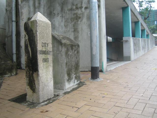
This is one of several stones erected to mark the limit of the City of Victoria, which was the official name for the city on Hong Kong island. Over 100 years later, you’ll still feel this is the boundary between the built-up Northern side of the island, and the less-developed Southern side.
Here you need to cross over to the other side of Pok Fu Lam Rd. You can either dash across the road if the traffic is light, or use the subway just next to the boundary stone. After crossing, keep walking up the road until you reach a set of traffic lights, and turn right into Mount Davis Road. The hill in front of you with the radio masts on top is Mount Davis, and down to your right is Kennedy Town.
As you follow the curve of Mount Davis Rd., you’ll notice some imposing curved stone structures on the right.
See the article for more details.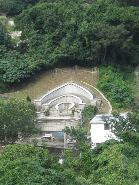
These are graves in the Chiu Yuen Cemetery, a private graveyard formed at the end of the nineteenth century for a very specific group – Hong Kong’s Eurasians. Interracial marriages were very rare in Hong Kong at that time, and the Eurasian community found themselves in a grey area as far as the colonial authorities were concerned. There was a colonial cemetery for westerners, and the Chinese permanent cemetery for Chinese – but no place for Eurasians until the Chiu Yuen cemetery was formed.
As you can see from the scale of their graves, several Eurasians became prominent members of the Hong Kong community, building on their unique strengths in understanding both Chinese and Western language and culture. Probably the most famous of these individuals was Sir Robert Ho Tung, and indeed it is the Ho family that owns this cemetery. Modern-day descendants of the Ho family include Stanley Ho the Macau casino tycoon, and Bruce Lee the late martial artist.
Keep walking along Mount Davis Rd., crossing to the left side of the road when you reach the small lane that runs down past the cemetery. When you can see through the trees on the left, you’ll find you are looking over to another, much larger government-run cemetery.
See the article for more details.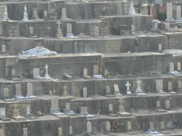
In death as in life, space in Hong Kong is at a premium with the graves packed in tightly together. You’ll also notice areas where there are no gravestones. The surprise here is that very few graves in Hong Kong are permanent, most are only rented for six to seven years. After that time the coffins must be dug up, and the bones removed either to be stored in a large urn, or cremated and stored in a smaller urn.
This section of the road has residential housing on both sides. When you reach the last block on the left, you should see a road sloping up on the right, with a sign for ‘Mount Davis Service Reservoir’.
See the article for more details.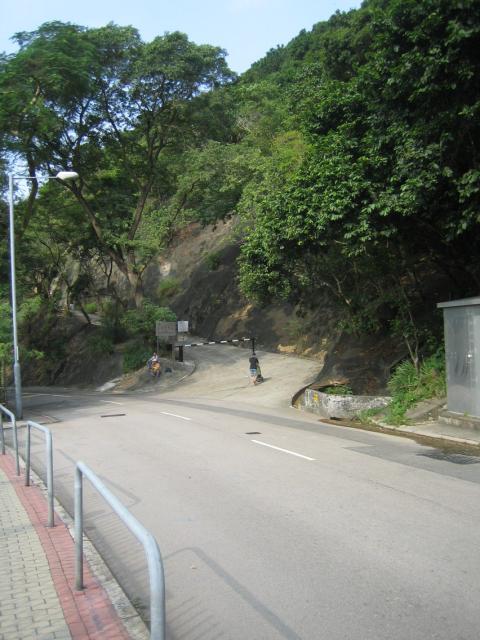
That’s the road you want to take - there is a barrier to stop cars from entering, but it is ok for pedestrians. (If you don’t fancy the climb, you can keep walking along Mount Davis Road. When you reach the roundabout at the end, turn right into Victoria Road. The next few paragraphs won't apply, so skip ahead until you come to the place we describe the ‘Mount Davis Concentration Camp’.)
As you walk up the hill you’ll have views out towards Lamma island, easily identifiable by the three chimney stacks for the Lamma island power station. Than if you turn and look back the way you came, you’ll see the sharp peak of ‘High West’ behind you. (There are steps to the top from the Peak side of that hill – it’s a steep climb but has wonderful views.)
At the top of the road you can turn right to take a breather in a little shaded pavilion, or if you’re feeling that the hill wasn’t enough of a challenge you can try out the adjacent exercise stations. In either case, when you’re ready to continue, walk along the road with the concrete wall of the reservoir on your right side. At the end of the reservoir turn left to walk downhill again. Ahead of you, between the two apartment blocks you should be able to see Cheung Chau, a dumbbell-shaped island. As you continue downhill, you’ll no doubt see a steady stream of container ships passing through the channel between Hong Kong and Lamma islands. Hong Kong usually ranks number one or two in the list of the world’s busiest container ports, and most of those containers pass this spot.
You’ll soon come to a junction on the hairpin bend of another road that twists up to the top of the hill. At the time of writing, the exit from the road we’ve just walked down was closed by a large stone block sporting a thick iron ring.
To make a guess about why that ring was there, it helps to know a little history of this hill. As mentioned above, Mount Davis has a commanding view of all shipping entering or leaving the Western entrance to Hong Kong harbour. The point wasn’t lost on the colonial military planners, whose main fear in the late 19th century was a naval invasion by one of the other imperial powers of the day. The Mount Davis Battery was built as a result, and was completed in 1912.
The road up the hill leads to the battery, making you wonder how all the equipment was moved up to the top. The guns used at this battery weighed 28 tons when completed! My guess is that they were moved with ropes, pulleys, and a lot of labourers. Of course you need somewhere to fasten your pulleys to, which brings us back to the iron rings. Follow the road down to the left, and if you keep an eye on the right wall you’ll see two more of the iron rings before you reach the main road.
See the article for more details.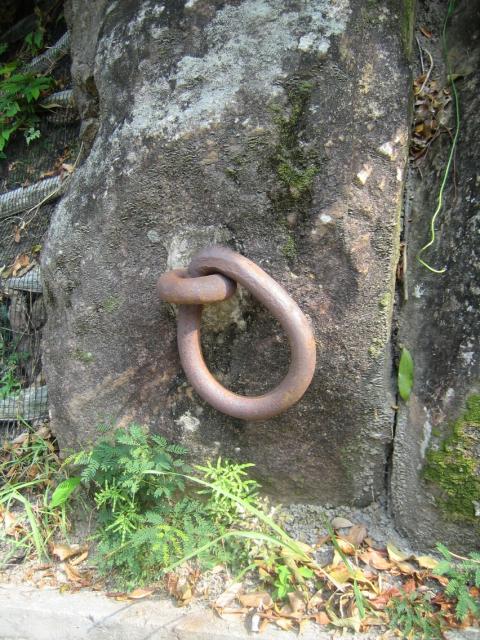
As you near the main road, you’ll see a concrete building on the far side, surrounded by a concrete wall with rolls of barbed wire on top. The building is empty now, but if you think it wasn’t a place that welcomed visitors, you’d be right. An article in the local South China Morning Post newspaper said that the buildings were originally the mess for the Royal Engineers Regiment, built in the 1950s. In the late 1950s it was renovated and used 'to hold Taiwanese spies caught smuggling explosives to the mainland'. Then in 1967 it was used to hold people detained during the 1967 disturbances. One of the ex-inmates described how he was held there for a total of 18 months, with the first 6 months spent in solitary confinement in a cell just 1.8m x 1.2m. The inmates at that troubled time called it the Mount Davis Concentration Camp.
When you reach the main road (Victoria Rd), cross over and turn right – the wall and barbed wire mentioned above will be on your left. As you pass the end of the wall you’ll have another seaview. The row of hills in the distance are on Lantau Island. You’ll see the Disneyland site in the center, and the end of the Tsing Ma suspension bridge just in view on the right.
From here the road curves right then left, then you’ll come to a small road junction on your left. The side-road is fenced off now, but leads to the old Jubilee battery, with three gun emplacements situated in and below the grounds of the ‘concentration camp’ building we passed a little while back. The battery was built in the 1930s to add to the defense of the harbour entrance, and took it’s name from the road we’re walking along now, which used to be called Jubilee Road.
A few steps ahead, opposite the bus-stop you should be able to make out a concrete gateway on your left, with red Chinese characters along the top.
See the article for more details.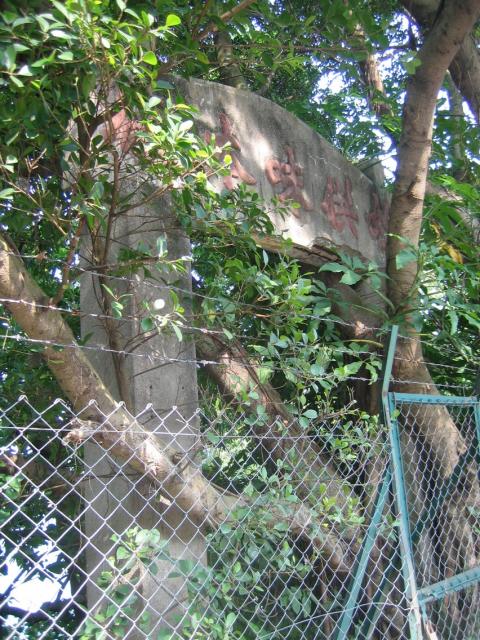
Along this section of the road, if you look carefully you'll see other signs of habitation, including steps, walls, and fragments of tiled floors. In the 1950s, Hong Kong’s population grew at a tremendous rate, as people fled from mainland China. Many of them ended up in the squatters’ villages that sprouted on hillsides all around Hong Kong, including Mount Davis. The villages have since been cleared and the people re-housed, but signs of the old villages can still be seen.
The next thing to look out for is a set of steps on the left, with two white signs above.
See the article for more details.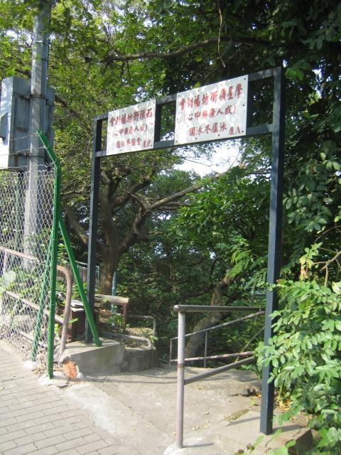
If you follow the steps down you’ll come to a small building, and below that a sitting platform, and a pier that leads into the sea. There are many of these ‘Winter Swimming’ clubs around the shoreline of Hong Kong, where sturdy folk meet each day for a swim, whatever the weather and season. Most of the clubs meet at beaches, so this pier is unusual. Still, it makes a lovely spot to sit quietly and listen to the waves.
See the article for more details.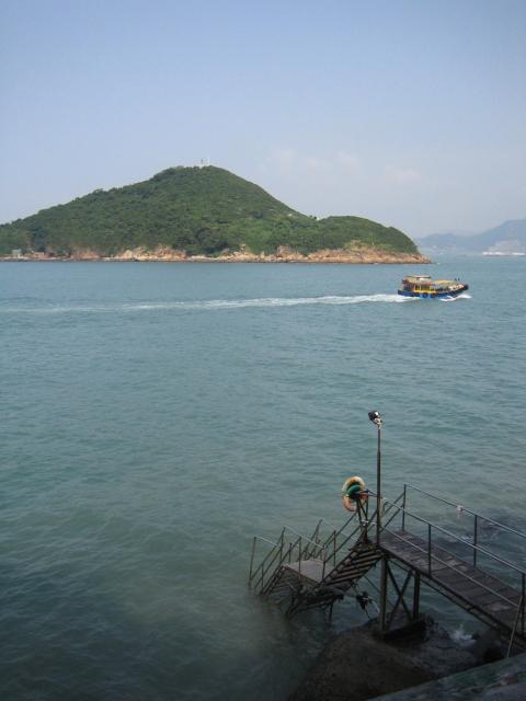
Comments
Back to Victoria Road and keep on walking. Look across to the hillside, and you’ll see a terraced area behind the bus stop. Although it already looks very overgrown, this was the last remaining part of the local squatter villages. It had the picturesque name ‘Mt Davis Cottage Area’, and was still inhabited right up to the clearance in 2001.
Follow your nose to our next place of interest (if you don’t trust your nose, you’ll see a raised walkway next to a blue sign on your left, then shortly afterwards a road entrance on your left). The 'fragrance' in the air comes from the nearby ‘Island West Transfer Station’, which handles all the garbage from the Western half of Hong Kong island. The rubbish is delivered in lorries to a large man-made cavern beneath your feet, where it is compacted into containers, loaded onto the ships that berth here, then taken by sea to the landfill in the Western New Territories.
On a warm day you probably won’t want to linger, so keep walking until you reach a concrete staircase on your left. Over the road you’ll see a lean-to structure.
See the article for more details.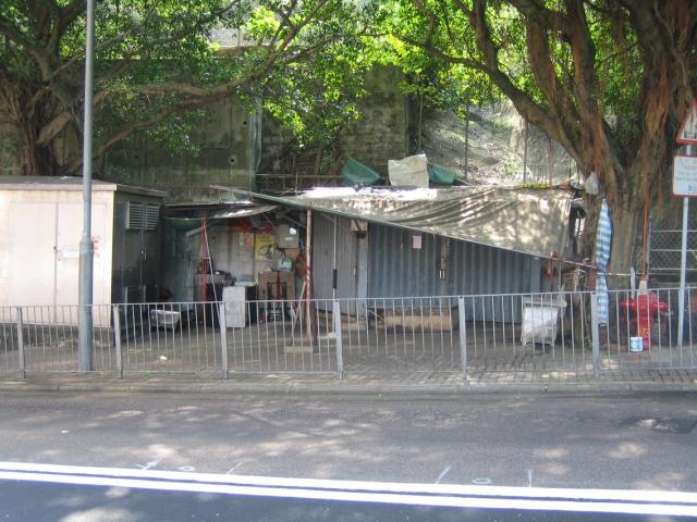
This is a clinic for ‘Tit-Da’, a type of Chinese medicine concentrating on joints, muscles and bones. Despite the primitive appearance, there is a queue of patients there most days.
Turn left and head down the steps, then at the bottom turn right. In the playgrounds at the bottom, you’ll find another of the boundary stones – welcome back to the City!
See the article for more details.
Be careful as you walk along the next section of road, as there are trucks and buses, and not many pedestrians. Walk on past the playgrounds until you come to a bus terminus. Just past the buses you’ll see a small garden that houses part of the façade from the old Tung Wah Smallpox Hospital, which stood on the hillside near here.
See the article for more details.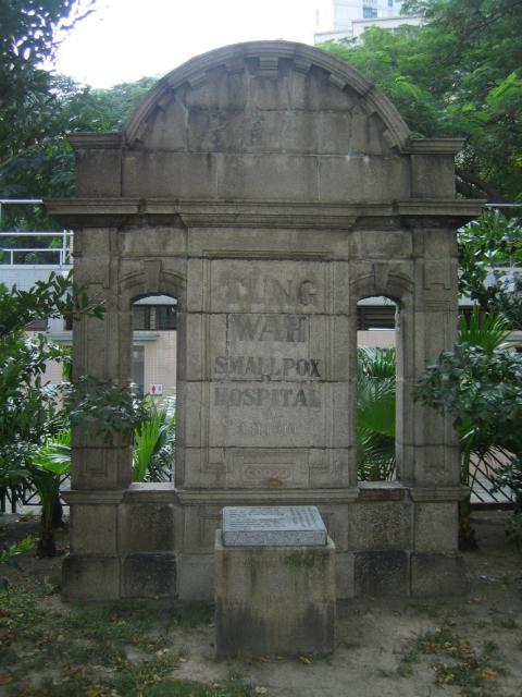
Hmmm... Cemeteries, a special branch detention house, a waste transfer unit, and a smallpox hospital. You’ve probably worked out by now that this district was considered a good place to put all the things no-one else wanted. To continue that theme, facing the garden is the public mortuary, next to that is the chimney of the public waste incinerator, and next to that is the public abbatoir! Thankfully the incinerator and the abbatoir have been closed for some years now, and the land is earmarked for use by the MTR when they extend the island line to here in the next few years.
Head back out to Victoria road, cross over to the far side and turn left. The first shop you’ll come to is a very ordinary household store to local eyes, but worth a moment to stop and look at if it’s your first time to Hong Kong. Fancy some rice bowls to take home? These are a bargain at just HK$3 each... Look for the wooden moulds too, used to make biscuits and mooncakes.
See the article for more details.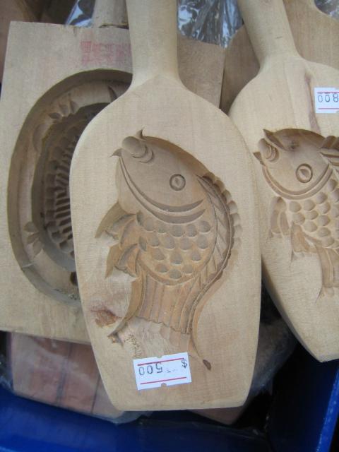
Next you come to a set of traffic lights, and Cadogan Street. On the left you’ll see the loop of tram line where trams make the turn to head back East along the island. It’s another option to get home – get on a tram at the terminus and bag the front seat upstairs for the view. Cadogan street to the right is the home of the K1 Bar. It’s the only Western bar in the area, so if you’re feeling thirsty it’s a pleasant place to rest awhile.
Still with us? Good, then let’s cross over Cadogan Street and keep walking, noting that Victoria Rd has now turned into Belcher’s Street. This area is a typical residential area in Hong Kong, so take your time to see what people are up to. You’ll pass Davis Street, Smithfield, then come to North Street. On the corner straight across is a popular choice for its congee (rice porridge), and noodles.
See the article for more details.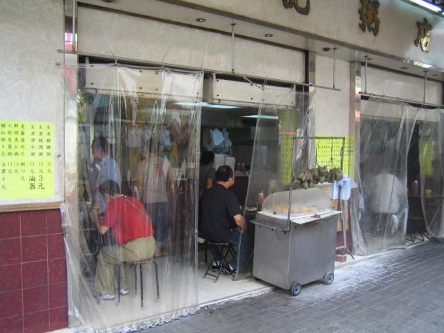
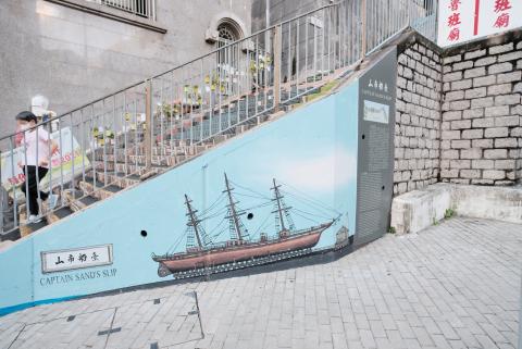
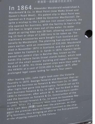
The next junction is Sands Street, and decision time! When you get there, pause a moment and take a look to your right.
See the article for more details.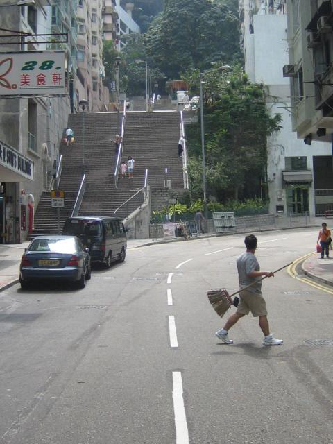
Comments


We’re nearly back to the start of the walk, but to get there we have to climb up the hill again. If you don’t like the look of the steps it’s probably best to turn left and walk to the next road over, Kennedy Town Praya. There you can catch a bus, tram or taxi back to Central district. If you’re feeling strong, head up those steps.
Just a little way up the steps you’ll see another staircase on the left, heading up to Tai Pak Terrace. That’s where we want to go. Mid-way along the terrace you’ll find some rare examples of what this area’s housing would have looked like in the early 20th century.
See the article for more details.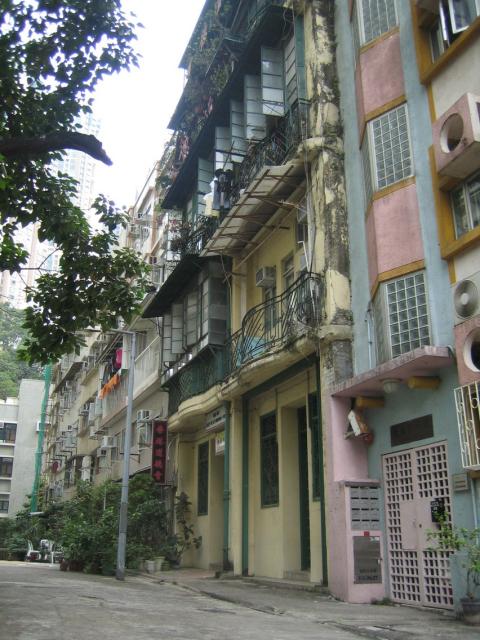
A government website covers this in their 'Western District heritage trail', and writes about the building and its owner:
Fok Hing Tong, Hong Kong Society for the Promotion of Virtue. The society was established in 1924 first on the fourth floor of 6-7 Tai Pak Terrace named as Fok Hing Tong. Inspired by Confucianism, Buddhism and Taoism, it promotes the study and practice of ethics and virtues. Its membership increased rapidly in a few years time and therefore in 1927, the society bought the neighbouring number 8-9 as permanent premises. The buildings are typical Chinese tenement houses of five storeys. Each floor has a balcony enclosed with intricate iron railings. The central part is articulated with a slight convex curve. The ground floor is usually rented out for income. These buildings represent the Chinese settlement housing type of the area in the early 20th century. The society also has branch offices in Tuen Mun.
Walk out of the far end of the terrace, and you reach Li Po Lung Path. Walk up the steps to the top, turn left and keep on up until you come to Ching Lin Terrace and the Lo Baan Temple. The government website again:
Lo Pan Temple. Lo Pan is the Patron Saint of Chinese Builders and Contractors. His real name was Kungshu Pan and was believed to be born in 507 B.C. in the state of Lo (ancient Shandong Province). His festival falls on the 13th of the sixth month of the Lunar calendar. Located in 15 Ching Lin Terrace, this is the only temple in Hong Kong erected to him in 1884 by the Contractor's Guild with donations from many people connected with the trade. The temple is a two-hall structure, with elaborate "fire" type parapet walls, sculptural figures, relieves and paintings. The land ownership changed several times and in 1921 was acquired by the temple management company Kwong Yuet Tong. A school was established in 1949-50 next door.
You are welcome to take a look inside the temple. When you are finished, keep the temple on your right and walk back to the steps and continue climbing. When you come to the next terrace, you’ll be at eye-level with the temple’s roof. It’s worth taking a moment to admire the ceramic figures in the little tableau built in to the roof.
This is a view of the ceramic figures on the roof of a local temple - "Lo Baan Miu". It's tucked away in Kennedy Town, so it is rarely visited. To get this view of the figures, walk up the hill from the temple to To Li Terrace, so you are at eye's level with the rooftop. This is the view of the rooftop above Hung Shing Temple on Queen's Rd East in Wanchai. If you look carefully, you'll see the quality is much poorer, several figures are missing, and the ones that remain have no heads! Lo Baan (the god of the temple shown at the top of the page) is the patron of builders and carpenters, so I guess the quality of construction reflects this.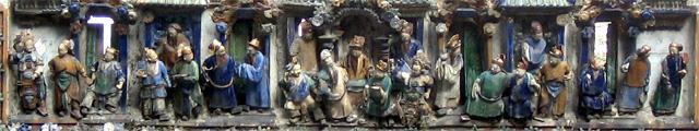
Comments

Then it’s back to the stairs, which bring you out to Pok Fu Lam Rd. Turn right and walk a short way up the hill to the bus stop where you can catch your bus back into the city centre. (No need to cross the road back to the terminus, as buses into the city stop on this side of the road.)
I hope you’ve enjoyed the walk. If you spotted any mistakes, if you would like to tell us about something interesting you saw along the way, or have any suggestion on how to make the directions clearer, please leave a comment below.
Regards,
David
More information:
Comments
Not on this route, but if you go a little further along victoria road and then down just after the West Island school before the old age home there is an entrance to what every much looks like squatter houses. Are they? Also the houses opposite the culinary institute on Pokfulam Road.
I've always thought of the houses below Sandy Bay road as squatter houses. But I'm not sure what makes the distinction between a village house, a squatter house that will be there forever, and one that must be cleared. Can anyone help?
The houses opposite the culinary institute are a bit different, as they are part of Pok Fu Lam Village, which pre-dates the arrival of the British. But it grew rapidly in the 1950's, with the huge influx of refugees that gave rise to the squatter villages elsewher. That was the time it was transformed from a little village to its current higgledy-piggledy layout. Again, I'm not sure what guidelines are used to decide whether a house is considered temporary or permanent.
Pok Fu Lam village has its own website, with a summary of its history.
Hi,
Your link to the village doesn't seem to be active anymore.
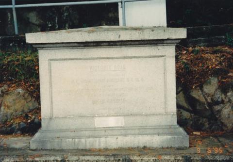
When I've got a moment I'll send you some links for the rest of Mount Davis Rd. There's also an interesting stone marking the opening of Victoria rd. on the corner of Mnt Davis and Victoria Rd, but it's very worn so hard to photograph with the inscription.
In 1897, Hong Kong marked the Diamond Jubilee of Queen Victoria with the laying of foundation stones by the Governor, Sir William Robinson for the commencement of Victoria Road and the Victoria Hospital for Women and Children on Barker Road. Both stones still stand today.
The Victoria Road Fondation Stone was initially placed at the western end of Hong Kong Island and later removed to its present site in 1977.
1995
Yes, the stones are quite similar in appearance. As Sir Paul Chater was the avid proponent of the Praya Central Reclamation Scheme and the Chairman of the Diamond Jubilee Committee, I will not be surprised if the same stone mason was used!
1996 Duke of Connaught Stone

Does anyone here know anything about Sandy Bay Village? I guess there are upper village and lower village coz I found two entrances: one is down there at Sandy Bay Road, right next to the Tung Wah Coffin House, only a few houses and sure still have people living there, another one I considered as the 'upper village', you may find a gov't sign on Bisney Road, and a stairway next to it will lead you all the way down to the village. I think the lower/upper one are not link together as they're located at separated areas. Most people focus on Pokfulam Village when they talk about squatters in that area, sounds like Sandy Bay Village is ignored by people as it is not even showed on centa/google map!
Hi there,
If you use the Map Search of Hong Kong Maps Service, you should be able to pull screens very detailed maps in various ratio. 大口環上村 is listed in the Chinese version of it. But in the English version only a few pieces of Cultivated Land are marked.
These maps are from the Lands Office's database. They should be quite accurate.
Best Regarsds,
T
I have published a book in Chinese regarding the history and life of the cottage area in 1960-70s. 山林之樂 - 摩星嶺公民村. The tit-da shop is the onlt surviving structure there for 60 years and still operating by the same family. Originally, it was a shoe repair and tea house.
Annemarie Evans joined me for a walk around Mount Davis, and recorded our conversation for her Hong Kong Heritage programme on RTHK.