Built : c. 1922/1923, with donation by Sir Paul Chater
Opened : 1924
According to Carl Smith's record [1], the Assembly Hall was at Cheung Chau Inland Lot 45. In the maps of Cheung Chau 1938 or present day, lot 45 seems missing.
CCIL 44 & 46 still exist today.
Could you help to suggest or locate its approximate location ?
By the way, its whole roof had caved in and all seats damaged, as newspapers of 1938. I just put a random placeholder on the Cheung Chau map above.
(update June 7)
Two more clues about the location I could find.
As W. J. Hinton's description in 1929, [2]
Of the foreign buildings the most conspicuous are the Meeting Hall of the European residents situated in the midst of their rather scattered bungalows,
and in the village, the red brick Police Station and the new School.
From Hongkong Telegraph (1938), [3] we read :
The Hall was built about 15 years ago ... It stands high on one of the island hills overlooking the reservation.
Does it offer some hints to confine its location to an area further southward ?
(update 28 Jul 2025)
one more hint from the papers :
... a letter to the Forestry Department thanking it for planting trees along the paths leading to the Assembly Hall. [4]
location of the pin is updated onto Fa Peng area to reflect findings to-date. It may be further fine tuned with new evidence and your inputs.
Please feel free to inform.
notes
1. grs.gov.hk catalogue
2. Cheung Chow - Long Island by W. J. Hinton on Journal of Royal Asiatic Society Hong Kong Branch (1977). First published 1929.
Mr Hinton had been Professor of Economics and thrice as Dean of the Faculty of Arts in HKU until 1929.
The day before, I was given 'the' location by perplexity.ai and referred to a gwulo page [link]. From the reader's mentioned, read in the Journal of 1977 and found another article instead. The location is actually some AI hallucination :D
3. Hongkong Telegraph, 1938-10-1
4. Hongkong Telegraph, 1925-8-5
Photos that show this Place
Comments
3 Foreign Buildings noted by Mr. Hinton
Good Day Folk!
Based on my past residency on the island of Cheung Chau in the 1950s through the early 70s, lot 45 is most likely a spot not far from the top of the Fa Ping area or its nearby ridge shared with Lot 47. From this height, it gives a very complete view, covering most of the European bungalows all around, most of those by Nam Tam Wan, some on the Peak road west.
Any ship and ferry coming to or leaving Cheung Chau's main harbor should be within sight of this spot.
The Red Bricked Police Station, as I suspect that it was not yet on the high ground next to the Tung Wan beach. It was near the Electric Power House, quite close to the village's business district or near the starting location of Peak Road. After some years, there was a horrific ambush at the police station, so they had got to build a very big and military-styled building situated in the center of a huge empty field with high metallic wired fence around the perimeter, as it is seen even today, after some major expansions. The design would hold up for stronger defense against any ambush from bandits.
The foreign School was a thing which has been in my speculation. Cheung Chau was not yet a part of the British ruling colony even though foreign missionaries had already visited and set up some church mission points there, under the Chinese jurisdiction of the Ching Dynasty up to 1898. And there was no School Road, it was a grassy hillside, as shown in some photos.
But the map in the 194os has The Penial Church addressed as No. 1 School Road. It implies a set-up of an educational corridor has indeed been developed. There is a school site I want to investigate regarding its origin. If someone could check on the first educator who operated this address: 12-c School Road (area : 8000sq ft) in the 1920s, 30s, up to the 40s. In 1958, my dad rented this site to operate the Ching Tak kindergarten. Before the early 50s, it was named Sum-Sum (heart-heart in meaning) Kindergarten. But I don't have any clue about what happened before that.
Its construction is quite unique and has a higher level of design than the other schools in the island village. The major classroom is just as roomy as a church assembly. Its back wall has a square hole designed solely for movie projection from the other classroom. The front yard is very big. Its backyard is on a lower terrace, overseeing a Boundary Stone, which is the one in Tai Choi Yuen. It seemed to be a property that tended to accommodate foreign children, not to mention that the London Mission had already secured an adjacent land deal, prior to church planting.
I still keep a photo from the early 1950s which shows the playground (Sum Sum Kindergarten) under the Twin Red Coral Trees was actually partially planted with lawn and a dozen rabbits were kept as pets by the school kids there. The picture shows that I was a toddler with the rabbit house in my background.
more clues?
Cheers
Tung
approx. location of CC Lot 45
Thank you Tung for the kind sharing and info. Extracted a map section for the said area.
CCIL 47 is 12A Fa Peng Road according to current Land Registry Lot/Address cross reference table for New Territories.
It is near the Fa Peng Knoll 花屏山莊 currently (on middle right of above map snippet; click and [zoom], [+]).
So if we infer with the contour line of 50 and 'near the ridge of Fa Peng Road' :
CCIL 45 may well be some high land between CCIL 46 and CCIL 47 (e.g. in the middle of map).
It may be refined to an area encircled by the contour 50 and slightly northward ?(the lot nos 44 to 47 also look more evenly distributed that way)
One more guess as a novice, with this Cheung Chau photo c.1924 (link), does it consider a high land for the few buildings residing on top on the right side ?
(just near the right side junction/crease of this stitched photo; press [zoom] to view)
any comments ?
The new school Hinton mentioned in 1929 may be the Anglo-Chinese School with red brick building as the admin report, at 5B School Road. Today it is the Cheung Chau Government Secondary School.
May add my ten cents for the other points you shared in a separate post later. Thanks again.
sources
- HK map services 2.0, with 'Multiple Lot Search'
- Gov't Administrative Reports 1928, p.531 etc
file : https://ccgss.edu.hk/sites/default/files/ccghis.pdf Readers may use google translate for this school history text in Chinese, using copy-and-paste.
other reference : David's walk through Cheung Chau's history in 2015 (link)
Three Foreign Buildings
Hello folk
The year 1924 view is made up of 3 pictures at different angles. The background on the left shows the hills and ridges of the Fa Ping region. The Assembly Hall could be somewhere over there, but it seems not to be in this picture because it hasn't been built yet. Therefore, it is impossible to pinpoint the exact location without further clues.
There seems to be a new police station building on top of a hill. It has both the Tung Wan beach and the village harbor in sight, for security against any sea bandit attack.
The middle picture is where the hillside of School Road can be identified. Nothing new except on the site of 5B School Rd. It is one of the earliest foreign houses. It could be the school noted by Hinton. It turns out to be the island's Post Office as I knew it from the 1950s, next to the site of Government School, which was still an empty site. 5B School Rd's building seems to be barely visible above the village houses.
The 5B School Rd site seems to be just too small for a school and not even constructed with red bricks in appearance. So, more clues are required.
The roads on the hills, in the 1950s, were mostly traditional walkways, muddy or stony slab paths and trails, even in the European Reservation. There is a very early photo, probably before School Rd. was built, which seems to be taken on a trail along this grassy hillside. (I like to show it once I get it later.) However, only the Peak Road seemed to be better built than the rest of those on the hills.
Most of the roads were upgraded to vehicle user quality in the early 1960s, but only the firefighting department, the police and the Navy patrol personnel have motor vehicles to use them quite once a while.
Many foreign bungalows can be characterized by their trees and plants around them. That can provide some clues related to or reflecting their property ownership or time in history.
Cheung Chau has long been a busy tiny hub for some foreign travelers!
Cheers
Tung
Fa Peng area, via Google Earth
The present day Fa Peng area could be viewed in 3D by google Earth also (link).
Cheung Chau L.M.S. Girls School ?
Hi Tung,
About the school site in 1920s you are interested in ... (link)
On the Admin Reports, there is only one 'non-local' school which was subsidized by government on CC. Recorded as early as 1920, possibly through 1926. (*)
Cheung Chau L.M.S. Girls School
pupils on roll 48 (42 girls) as for 1926
May it be on that site originally, whereas later a property seems more for foreign children ? That school is related to London Missionary Society though.
By 1936, only one other protestant missions listed on the Directory : South China Peniel Holiness Mission (SCPHM), on Cheungchow.
That is related to the Peniel Church you quoted, I think. The CC one founded on 1 School Road, nearby.
My two cents.
Best regards.
sources (*)
Government Administrative Reports, 1920 (up to 1926); the rest of the schools being all with Chinese names
Early Schools near No1 School Road in Cheung Chau
Hi
Thank you for the new information, I realize that Cheung Chau L. M. S. Girls School in the 1920s could have been the same site as Ching Tak Kindergarten or today's Yan Chak Yuen. The address is 12 c School Rd. It is only a pure assumption.
But as a rule in the 1950s, all kindergartens were privately funded. If the school was a regular one, backed and operated by the 'non-local' LMS, I think it could still be subsidized by the government.
As for the red-brick school, it could also be in the same neighborhood area.
Cheers
Tung
Foreign School in the 1920s
Hi folk,
In the 1950s, there was a school named Cheung Chau Girls School which was in quite a different location. It was near the Cheung Chau Baptist Church area. It was one of the few private schools operated by local Christians on CC island, obviously having LMS support. But it was for the local girls only. However, as the school later became government-subsidized, it also accepted boys too, without any change of the school's name.
Eventually, the school moved to a new site on Peak Rd. West in Fairy Well area.
Back at 12c School Rd., the kindergarten was known to have some students who were from mixed-race families. Could that be so-called a Foreign School?
Moreover, I was told, at 12 School Rd., the address seemed to be a building for a bible school at one time in the early 1940s, prior to being a regular residence. That bible school later moved away from the island.
LMS did have a supportive role in its mission plan in the area, I think.
Yet none of these were being built with red bricks.
Best Wishes
Tung
PS : 12 School Rd. and 12c School Rd. are two different addresses.
Re: Assembly Hall
As I understand, the Assembly Hall was built on a hill in the then European reservation on Cheung Chau. The exact location is not clear but known to have been on Cheung Chau Inland Lot No. 45.
Notes compiled previously. Further information:
2. The contract for the erection of the Cheung Chow (sic) Assembly Hall has been let to Chun Hung of Cheung Chow, at $6,300. Work will begin this week. Source: HK Daily Press 12 November 1923.
3. Permanent residents met on the site of the contemplated Assembly Hall which was expected to be completed in time for next summer and take the place of the Palmleaf Hall that has been put up each year for Church services and social gatherings. Source: China Mail 13 November 1923.
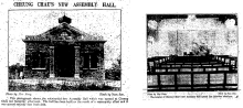
4. Good progress made with the Assembly Hall. Most of the roof is finished, including the belfry. Source: China Mail 8 May 1924.
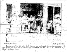
5. The Assembly Hall was opened by Lady Severn on 19 July 1924. It was built on a hill with pathways that radiate to all parts of the island. Source: HK Telegraph & China Mail 21 July 1924.
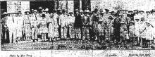
6. Group photo taken outside the Assembly Hall after the opening by Lady Severn. Source: China Mail 23 & 24 July 1924
7. The Assembly Hall was a single-storey structure. A description of the Hall is given in the China Mail 24 July 1924.
Three Foreign Buildings
In the late 1950s on the Fa Ping peninsula, only one European house remained to be a total ruin as the result of past Japanese occupation. The roof had been completely blown off, so were parts of the surrounding walls. It looked like the destruction was done by grenades and dynamite explosions.
We kids sometimes go there playing games like hide-and-seek. The wall overlooking the cliff is quite well-preserved with window frames quite intact. It is a bungalow built of granite that has a rectangular house plan. As for the interior, it was quite empty in design. I would not disagree if it was the remainder of the Assembly Hall in our recent search. Here, high on top of this wonderful spot with ocean in view, plus sea breezes and cooling winds, one would question when the ruin will get a total new replacement.
The location seems to be matching up with today's Fa Peng Knoll, just next to IL 26.
During the years attending the English College near the junction of Fa Ping Rd. and Bosco Rd., sometimes my PE class teacher would force us to run uphill on Fa Ping Rd., passing the ruined house, turning north to the Salvation Army Orphanage House, and running downhill back to the school field.
This ruined structure seemed to be there even in the early 1960s. At the time many new construction projects began to spring up in the Fa Ping and Nam Tam Wan areas, including the Caritas Retreat Camp and the Bosco Catholic school for priesthood.
I can still sketch a picture or two in brief from memory of it.
Regards
Tung
photos of the assembly hall and its interior
Moddsey, thanks for your detailed notes. Tung, thank you for sharing the first-hand anecdotes. Looks like our findings and recollections in the last 24 hours complement each other's. 👏
I come across few photos of the hall on a later newspaper by full-text search, samples below. Some arch is seen at the doorway of the building in another photo.
Would defer my notes about the two schools (e.g. the red brick building) to a later post.
Roof collapse in 1938
From page 9 of China Mail 1938-10-01:
CHEUNG CHAU ASSEMBLY HALL ROOF CAVES IN
The residents of Cheung Chau Island were startled by a loud crash which occurred at 6:30 a.m. to-day.
On investigating the cause it was discovered that the whole roof of the Assembly Hall had caved in and every seat was broken and flattened out. What would have happened to the congregation at church if this had occurred tomorrow morning during the usual Service is too appalling. The whole roof was repaired only last year after the severe typhoon which visited the colony.
WHITE ANTS
The Assembly Hall was built and donated by Sir Paul Chater about 16 years ago to the trustees of the Cheung Chau Residents’ Association. The supposition is that the wooden beams supporting the roof were eaten and decayed by white ants and sheared off at the two ends.
1930s Cheung Chau Photo
I think the Assembly Hall should show up in photos of Cheung Chau from 1920s/30s. Perhaps the building on the left above the two larger buildings in the left foreground ?
The Assembly Hall
Hello folk,
A picture worth a thousand words!
What I mean is the critical clues from one of the two photos (both dated July 1924), which appeared in the newspaper, showing on the left its front entrance and the porch, and the photo on the right is the interior of the Assembly Hall. The photo on the left has more very useful information.
My earlier description of the ruined European House seems to be no match for the shape and height of the Assembly Hall which appeared in the old newspaper, so frankly to say that my speculation is not possible. Never mind if it was nearby or not.
The good news, nevertheless, comes directly from the picture. The picture on the left has the critical clues. There were three people standing beside the hall near the rear. Their due north background indicated a part of European House #5, which is the one close to the highest hilltop on the Fa Ping Peninsula.
So the only candidate would be European House #12, most likely the lot I L 45. That perfectly satisfies the clues given, so far so good. The location is a hub which had pathways leading to different hills on the European Reservation pathways.
Another 1930s photo submitted by moddsey on 07/23/2025.
Carefully reviewing the geographic layout of the European Houses, one would have difficulty sorting out the outlines of the hills, the ridges and the hidden vales and valleys. As a local islander, I remember fairly well about that.
For this picture, the photographer was standing in the vicinity of today's Xavier House on Peak Rd. West, capturing the view of his north=east direction. The foreground shows houses that seemed to be House#28 and #28A, in the Fairy Well area. Further on the right is the headland of Nam Tam Wan area. The pathway of Peak Rd. is clearly visible, and so is the bending to the west.
Beyond this would be the Fa Ping area, which had the largest number of European houses. The tallest hilltop, which was House#5, which, I think, was the image that appeared over the three people mentioned.
House#12 was not entirely visible due to a visual obstruction by a bigger bungalow on the top of Fa Ping Rd., but the roof of house #12 is actually barely visible. It seemed to be right between the house beyond and the bigger one in front.
I think the unique bell tower lookalike on the rooftop is a very important feature, as visible evidence. This seems to be conformable with other photos. Another aerial photo of the year 1938 did reveal the same, through the shadow projected by the bell tower lookalike on its rooftop. This lot, IL 45 if that was the case, seemed to have two houses. One was house #12 and the Assembly Hall, a later addition.
But the location is really too remote.
Regards
Tung
try to zoom in to the location
Hi Tung,
Based on your hints, e.g. House #5 and #12, my try to estimate the present day location as below. Here, mainly use the notations and resources already cited on gwulo.
1938 map : CCIL 1A, House #12, House #11, nearly forms an equilateral triangle (link 1a)
1924 aerial : three such buildings may be observed similarly also (link 2; can maximize to above level 15)
My guess is --
1938 map : next to number '12', about north-east direction ? (link 1b) ** just take the top-side of map is north, as convention
today's map : next to CCIL 29, about north-east direction ? (link 3)
or, more south-west ? (if I mistake mostly, please correct me)
To specify the location of the hall more clearly, the letters A, B, C, D are put on below photo as reference points for this neighbourhood.
You may pinpoint and describe the approx. location by reference to them. It is just a cropped image from link 2.
Any clues from 'another aerial photo of 1938' and other info you have ?
Ideas from other ongoing readers are most welcome.
wl
note : Land Registry online enquiry is quite a handy tool (link); may input 'CCIL xx' directly
The Assembly Hall
Hello hk...
Assembly Hall is C or a second house in its proximity, between A and D.
Could it be possible for the lot I L 45 being created to harbor the house of Assembly Hall.
Tung
The Assembly Hall
Hello hk...wl,
Here is the summary:
From the two July 1925 newspaper photos, the size, the entrance by the porch side, at least one bell tower lookalike on top of the roof's ridge line. It showed the size of the hall's interior. The image visually blocked the view of two other houses up and behind, the Salvation Orphanage and its neighbor as marked as A. The hall existed roughly in a north-south direction, consistent with the pathway along the west wall of the hall which was fairly in line of sight to house#5
B was not visible from here because it was some place down the roll off of the cliff.
2.
From the 1930s photo, sites A, C and D were in the line of sight with most of the whole roof of the hall, site C, being hard to identify. There seemed to be lookalike bell towers or simply a chimney on the roof.
3.
From the November 25, 1924, aerial photo, we can check if house #12 was the only building on this I L xx, before the existence of the Assembly House.
4.
The ruined house from my memory remains to be a mystery as more clues are needed.
Regards
Tung
A Damaged Assembly Hall
Hello folk
I remember......
Several years ago, I saw a photograph of a European house in Cheung Chau with a damaged roof. Now it suddenly becomes a piece of evidence or a clue to my search for the Assembly Hall on Cheung Chau's European Reservation during the 1930s.
The capture of this photo has been uploaded to Gwulo media library.
At the link, https://gwulo.com/media/51603
Cheers
Tung
Comparison with Building with Damaged Roof
The damaged building recently posted is shown below.
Comparison with the side view of the 1924 Assembly Hall.
An extended side view.
Appears to be two different buildings.
today's location near 12 Fa Peng Road, but a bit eastward
As the landscape, this location today is also north to Fa Peng Knoll Blocks 17-19. (link) (*) This is possibly the location where the Hall was built.
For reference, google street view of the south side of this Lot on 12 Fa Peng Road (Bethany Ministries Lodge) is here. One tall tree still remains on the road side.
We may try to approximate this present day location of the Hall in two different ways :
- if I layer the 1924 aerial over the present day map (link 3) with photo editing software, could see the building at point C is at the updated pin position above
- gwulo readers may see similar effect by using the slider bar on top right hand of Map of all Places (can slide it down and up)
firstly, choose the '1938 Cheung Chau' map under Maps;
then, zoom to the Fa Peng area of Cheung Chau as shown above;
next, to view the outcome, pull the slider slowly downward will produce a transparency effect and you can see location of the "12" (House #) roughly
over the area of today's Fa Peng Knoll Blocks 16-20 (*)
(*) with some tolerance in alignment and inaccuracy between maps
That appears to fit in with all other conditions discussed above, with no conflicts.
some leads for readers to come (tba)
. . .
p.s. I have put some remarks about the damaged roof photo, just double click that photo ('Possible Candidate ...') above will take you there;
think discussions can go on in parallel in that post as a sub-topic.
1920s Cheung Chau
I was looking at the photo below. In the centre of the photo on the right of the two-storey structure on the hill is a building that appears to have a belfry. Would this be the Assembly Hall?
The Assembly Hall
That's a 300% No!
It's too big and like a school. It's facing the open water, from Nam Tam Wan. It's not on high ground either.
It was a Catholic institute or Abby near the turnaround of Don Bosco Rd. Their ministry is an attribute of the Vatican.
The Assembly Hall seemed to be used by the Protestants of different denominations only.
Tung
Re: Assembly Hall
Noted the % reply and subsequent elucidation.
The Assembly Hall
Sorry, I misread the one in the foreground!
The two-storey building on the hilltop near the right of the photo's center was by Peak Rd. It seemed to be the Jeffray House, quite a distance away from Fa Ping area. Not too far from it, the next house seemed to have a belfry. I don't know, but it is seemingly unlikely.
From the newspaper photo, the hall seemed to be directly south of House #5. The subject on the roof seemed to be a cover for the chimney and the installation of a lightning rod. The latter was necessary for building on higher ground, I suppose.
Tung
Re: Assembly Hall
Thanks. All good.
The Assembly Hall
First, many of the photos that are used by me to explore this view of Fa Ping Highlands were taken from the yard of House #29, in the Fairy Well area. (Let me name this house as point A.) They displayed quite a lot of past European houses scattered around and identifiable throughout the Nam Tam Wan landscape. So I can easily determine various lines-of-sight towards the houses in the Fa Ping area.
Secondly, I use the aerial photo of Nov 25, 1924 to locate any possible assembly hall building. I would name that to be point B. Keep in my mind are the critical clues about the ground, the trails, clearings and the background house #5 nearby. This way, I can get a better way to locate the Assembly Hall solely based on the photos taken on the day of the Hall's opening, July 19, 1924, eliminating the photo of a house with a damaged roof. So I obtained point B.
Using the proper length of thread to link up from A to B. To my disappointment, Point B seemed to be quite invisible from point A, a view being blocked by the higher ground to its south.
Point B is the site of today's Bethany Lodge. Only a possibility.
Tung
Re: Assembly Hall
As a longtime resident of Cheung Chau for over 20 years—mostly in the Fa Peng and Nam Tam areas—I've thoroughly enjoyed the photos, discussions, and historical details shared here about the Assembly Hall.
I'm particularly curious about its origins: Why was it built in Fa Peng back in the 1920s, especially when local residents apparently had no access to it during that era?
I'm quite familiar with the marked location on Google Maps, and today there's absolutely no visible trace of any former structure there. That said, it doesn't rule out the possibility that a building once stood in that spot.
The Assembly Hall
It is a very good question!
Tung
Re: Assembly Hall
Dear Tung,
I guess the simple answer, which was already mentioned above, is:
The primary reason for its construction was to provide a permanent venue for church services, social gatherings, and events for European residents on the island, as the temporary Palmleaf Hall was inadequate. The government granted the site at a nominal rent, as recorded in the 1922 Report of the New Territories.
There must be many more foreigners visiting/residing on our island than I could have imagined, given that they built a hall for 200 people on a hill, which would take at least 25 to 35 minutes to walk to at that time.
Re: Assembly Hall
If anyone would like to visit the site at Fa Peng, please let me know. I would love to join you.
Three Foreign Buildings
The only red-bricked foreign school building I can think of is the Government High School. I knew quite a number of local islander leaders were among its earliest graduates.
The location is near to the starting point of Peak Rd. School Rd. is just about a soccer field away from its west side.
Tung
Building on a Hill with Radiating Pathways
One of the comments made of the completed Assembly Hall in 1924 was that it had pathways that radiated to all parts of the island. China Mail 21 July 1924 refers.
Looking at the 1924 Aerial Map, there is a building on a hill near Kwun Yam Wan that has such features at botom left. Would this be the elusive Assembly Hall?
For some unknown reason, the building does not appear on the 1938 map.
Photo related to the Assembly Hall
I found a photo from THE COVENANTER WITNESS Vol. 21 P.267 of the Reformed Presbyterian Church of North America that mentioned moving the Language Institute to Cheung Chau due to the fall of Canton in 1937. The photo taken is highly likely to be Cheung Chau Assembly Hall.
In the article, a table was attached to show different missionaries' divisions and their student numbers. It seems that a number of missionaries moved to Cheung Chau due to the war in China.
"The South China Language Institute Rev. Samuel E. Boyle
War clouds have not frightened these young candidates for missionary service in South China. They are studying Cantonese in the South China Language Institute, Cheung Chau Island, near Hong Kong. This school is one organized by several Christian Chinese men who are among the most able and experienced teachers of the Cantonese dialect in this district. Before the bombing of Canton by Japanese planes became a daily ordeal this school was prospering in the eastern part of Canton. In the fall of 1937 the school, teachers and students moved to Cheung Chau. At the end of July the first year's work on Cheung Chau came to a close. The new term opens today (September 5). Although the photograph does not include the entire student body some idea of the division by denominations can be obtained by a study of this table:
These twenty-eight include only the ones shown in the picture. In the front row are the nine young Christian Chinese who manage and teach in the Institute. This picture was taken April 1, 1938. Other missions in South China have been sending word to their respective boards advising all candidates for South China service to come out as soon as possible to take advantage of this fine opportunity for quiet study in a secure place. This fact explains our own South China Mission's answer to the inquiry of the Board concerning Dr. Gertrude Martin and Mr. Lester Kilpatrick coming this fall to begin language study. We join with other missions in urging new workers to come now to Cheung Chau where in beautiful surroundings they can begin the study of Cantonese. From all reports another successful year is beginning now and new students are still coming from England, America, Germany, and New Zealand to get ready for work in China after the present war comes to an end. The regular course required for graduation is two years of varied study with classes and with private tutors. The present language school is said to be the best South China has ever had provided for new missionaries. ..."
The Assembly Hall
Happy to see the extra information.
Will talk about them later.
BTW, as for the aerial photo (on Nov 25, 1924) presented by Moddsey, the house at the bottom left is on the south bank of Vale, which later became the site of the famous soccer field solely for Europeans. This house had a complete background quite different from the photos given of the Assembly Hall.
Tung
Post-War Photos of Assembly Hall
As I understand, a great majority, if not all, of the missionary bungalows and buildings received serious damage and looting during the Japanese occupation. The Assembly Hall may not have survived the war.
It is interesting to note the Hedda Morrison Collection of photographs from 1946-47 does contain a few views of Cheung Chau. But none were taken of the former European Reservation and its bungalows.
Re: Assembly Hall
Aldi's inputs below refer to the building on the hill at top left.
(deleted an image that previously showed the building as European House #2)
Apologies
My apologies, I've had second thoughts about that since doing that page, so I have changed my pic accordingly. To me it doesn't look like the photos on the House #2 page.
Actually I think that number 2 is just beyond/behind the building I'd marked, and the building I'd marked as #2 is a very good candidate for the Assembly Hall. On the 1930s photo the left-hand side looks like the front of the hall with its columned portico. The orientation is right. And a
cupolabelfry at this end?The only caveat is that the building on the 1930s photo seems to have a verandah on the side facing us?
Modern buildings on that site could be the Marine Port District Junior Police Call Cheung Chau Clubhouse (moddsey's building radiating paths). Is that on elevated ground?
Confirmation?
I think on this crop from tonyb1943's 1920s picture we may have a view of the rear of the Assembly Hall. There seems to be a portico at the left end. It has a
cupolabelfry and the roof shape matches.The view is from the vicinity of Seascape Peninsula at Nam Tam Wan, marked X , between 18A and 21, and past what I have called House #22.
Confirmation welcomed.
The Assembly Hall
Very interesting indeed!
Will certainly check on it. No stone unturned!
Tung
Hong Kong Daily Press 1909-09-06
"While suggesting a future for the island it might be as well to mention some of the ideas of the missionaries on the subject. They hope to obtain from the Government a portion of land which could be utilised as a public place of recreation, with a tennis court, and they have ambitions for an assembly hall or school where their children could be taught".
Source: HK Daily Press
1924 Cheung Chau Assembly Hall photo
Thank you to Moddsey and Aldi,
Your suggestions are very good. The image of the house does look like the Assembly Hall even with the obscurity of an aged photo.
With your helpful clues, I re-visit one of the photos on the site at https://gwulo.com/media/16283, as 'Pictures for Tung'. The small house by the hilltop of Kwun Yum Wan (Afternoon Beach) could be the same as mentioned in the following discussion.
Now I am talking about a site that is much closer to the town. It is near the junction of Peak Road, the top of School Road and the higher end of Kwun Yum Wan Road. It makes better sense for easy public access with convenience. (Further away on the Peak Road is the Nam Tam Wan area).
This small cubic house seems to be a good match with the one small house appearing in one of the Assembly Hall photos, which had three people standing by the left wall near to its rear.
So actually, there is a small valley sitting between the site of the hall and its background house and hill. It runs all the way to a tiny outlet open to the water of the Nam Tam Wan. Over this small valley towards the open water of Nam Tam Wan, there should be a view in line of sight between the southern end of the Seagate Peninsula and the east end of the Assembly Hall, as suggested by Aldi. But that is only valid based on old photos. (Today, it may not be the same.)
As for the small cubic house, it was quite difficult to see from the aerial view photo. It seems quite easy to check from those of 'Pictures for Tung'.
So far, I tend to confirm your validity.
Tung
1920s Cheung Chau Assembly Hall
My query on 30 July 2025 to tonyb1943's photo regarding the building on the hill (with belfry) is the same building suggested. Thanks to Aldi for the additional clues for making the case stronger.
1924 Cheung Chau Assembly Hall photo
I agree.
Tung
First there!
So you did moddsey! So really you were first there. I came from a different path and only realised it yesterday.
And I prefer your 'belfry' to my 'cupola'. Will make changes.
Can we go ahead and add connections?
Re: Cheung Chau Assembly Hall
I am agreeable. Perhaps hkspace_wl may wish to comment on the latest findings/clues as the initiator of the discussion. Thanks.
(Resolved) The actual answer is here..
As the plan of the lot CCIL 45, the place is right. It is north east to CCIL 30.
Possibly none of the us probing on this post has had HK property agent experiences before. Else we may not need going so far, finding alternative ways to track it down.
Btw, this is also in line with an old Cheung Chau kaifong's oral history jotted down on the Footprint of CC Facebook recently. (**)
sources
(**) including the 'Weather Station'; this is in fact supported by what HKO has documented. May simply refer their annotations on a 1980s map here;
together these provide good evidences of the development history of this site
>> please advise if you have any comments or inquiry on my findings posted here on Aug 30
Cheung Chau Concert ( 1940)
I would like to check the historical event based on the timing.
1940 was the year when many foreign missionaries in South China suddenly had to leave for Hong Kong. Some of them decided to transfer the most vulnerable orphans to Cheung Chau because the fall of the City of Canton resulted in a very harsh life for people under the fear of military occupation and serious shortages of daily goods and materials. As for some orphanages, saving the infants and toddlers was their priority.
During the harvest season in the autumn of 1939, China had, for the first time after many serious defeats, the loss of the major cities of Shanghai, Nanking and Wuhan, and areas along the path of invasion, eventually become stronger and wiser enough to defeat a massive Japanese aggression attempt to seize the city of Cheungsha, a critical hub of the railway network of the South west China in the province of Hunan, which provides also a vast vital region with abundant food replenishment the Japanese army desperately needed. It was at the same time when World War II had just broken out in Europe.
Since then, the Japanese army, together with its air power, has failed to win further meaningful territorial gains to sustain its survival in China.
Hong Kong remained quite a safe city to stay in at that time. Soon after, it was packed up with many refugees. The role of some church missions in Cheung Chau's European Reservation had to change to include them as caregivers to orphans from their orphanages in Canton and other cities.
A concert at the Assembly Hall was probably a positive thing to do.
Tung
The 12c School Road and nearby area in the early 1960ss
A 1960s picture of the playground and front garden of CTK :
https://gwulo.com/media/20441
About the photo...
A photo of Ching Tak Kindergarten students and the staff. Probably they were just celebrating the last day of the semester and the beginning of the winter holiday.
The Gigantic Twin Red Coral Trees had already shedded off most of their leaves. In just a few weeks, the beautiful red coral flower clusters will sprout out all over the branches, in time for the Christmas season and Chinese Lunar New Year. Gradually, their new leaves will regenerate greatly as Springtime approaches.
A sun-lit church on the far-right in the background behind the Red Coral Tree is quite traceable, if not noticeable, is the original Church of Christ in China on Cheung Chau island.
History in question...
It is worth mentioning one site in this neighborhood, a place called Tai Ser Tan, just about a hundred feet southwest of the Penial Church (#1 School Road), is known to people who want to seek advice from the dead. Here the word 'Tan' means an altar. A woman is the only priest who does just that for a living. It seemed to us a lot like one of the Chinese shrines. It is actually not, its practices have some similarities with the medium of ancient cults in the Middle East or in Africa. Our curiosity towards this had been warned by most people. So we never know what it is.
2. Are they being planted by those who were among the Persian traders? For the great old Red Coral Trees seem to come from countries around the Indian Ocean, like South East Africa. So is a religious culture too.
Tung