
Where: As the title says, we're up at the Peak, looking out to the southeast with Mount Kellett over on the right. Here's a modern map of the area, with the red dot showing where I think the photographer was standing, and the arrow pointing in the direction we're looking.

I've also highlighted the main roads:
- Yellow: The road from Victoria Gap and the upper terminus of the Peak Tram to the very top of the Peak, known as Mount Austin Road today.
- Purple: The road to Victoria Gap from Central. The earliest residents of the Peak would have been carried home along this road in sedan chairs. Today we call it the Old Peak Road. (Originally the Old Peak Road and Mount Austin Road were one continuous road known simply as Peak Road.)
- Green: Plantation Road.
- Blue: Tramline of the Peak Tram.
- Orange: The road from Victoria Gap to the Pokfulam Reservoir.
Here they are on the photo.

When: The eBay seller described the photo as:
View from Victoria Peak Hongkong China Vintage Albumen Print 1880s
But sellers often knock a few years off the date of a photo, hoping that an earlier date gets them a higher price. Is this really an 1880s photo?

The first clue is that we can see the tramline. The Peak Tram started running in 1888, so the photo wasn't taken any earlier than that.
The next clue is something we can't see: just after Plantation Road passes under the tramline, a modern photo would show the junction with Barker Road. Construction of Barker Road started in October 1897, but there's no sign of it in this view. That gives us a ten-year window of 1888-1897 for when the photo was taken.
Our next clue is this grand building.

It's the Mount Austin Hotel, which opened for business in 1891. It wasn't a great success, and was sold to the government in 1897, when it was converted into army barracks.
Some time during the 1890s the building saw a major extension. Here's a view of the building from a later postcard, with the additions highlighted.

If anyone knows which year the hotel / barracks buildings were extended, please leave a comment below, as it may further narrow the range of years the photo could have been taken. Until then, we can say the photo was taken between the opening of the Mount Austin Hotel in 1891, and the start of work on Barker Road in 1897. Not quite the advertised "1880s", but not too far off.
What: Let's take a closer look at the buildings in the foreground, then make our way downhill, before finishing with a mystery I hope you can help solve.
I've highlighted the three nearest buildings.

- Red: We only get a glimpse of this one. I believe it is Tor Crest, but please correct me if I'm wrong.
- Blue: This is the pair of semi-detached houses known as Meirion.
- Green: The third building, with it's curiously narrow second storey, is Bahar Lodge. The owners must have found the second storey a bit odd too, as later photos show the building with its second storey removed, and a flat roof in its place.
All of these buildings have long since been demolished. Today you'll find Overthorpe occupying the combined site of Meirion and Bahar Lodge, while 22A & 22B Mount Austin Road stand where Tor Crest used to be.
Streams and a waterfall
Just to the right of Bahar Lodge, the road bends as it crosses the stream I've marked in blue.

After the stream makes that sharp right turn, it is hidden from view. Maps show it merges with two more streams that flow down from the Peak, then the enlarged stream reappears in a more lively form.

The three streams feed the Lugard Waterfall, a popular sight along Harlech Road, especially after rainy weather.
Returning to that bend in the road, here's the view today.

I could make out that the ground dips into a valley, but otherwise it is very difficult to match the modern view to the old photo - there's just so much more vegetation today.
However there is an easier match if we walk a little way downhill...
Haystack

The house was called Haystack, and to get to it you'd have to cross this bridge.

There's still a building on the same site today, and you still have to cross a bridge to get to it. The span of today's bridge looks to be modern, but the stone supports on either side may well be the originals.

The current house is still known as Haystack. It is much larger than the 1890s building, but there's a chance it's an extension rather than a replacement. Do readers know if any traces of the original building remain?


The Umbrella Seat
Continuing downhill, at the corner we can see the Umbrella Seat, a popular spot to sit and admire the view out over the city and harbour. (Today we'd think of Lugard Road as the prime sightseeing spot, but it hadn't been built when this photo was taken.)

The current seat is a newer design than the seat from the 1890s.


But not so much newer, as photos from the 1920s show this 'new' design was already in place.
It no longer attracts the sightseers though, as this is all the view you get today.

I'd like to see these trees and bushes given a trim so that visitors can enjoy the view again.
Finally, that mystery building.
In the 1890s, the ground in front of the hotel sloped steeply down towards the stream we mentioned earlier.

Looking at the above crop, note the corner on the right where the road disappears behind the hotel. If you stand on that corner today and look up the valley, you'll struggle - there isn't any valley to be seen! Instead you'll see the flat ground of the Mount Austin Playground, a small but very well-kept park.

A surprise but no great mystery - Hong Kong is always cutting rock away here, filling in a dip there, all in the quest for more flat land to build on. But look more closely at the old photo to see the mystery: the roof and chimney of a building at the bottom of the valley.

I haven't seen it in other photos or maps, so I wonder what it was?
The present-day park has public toilets in a building that is at a similar location as the roof and chimney. At first glance it looks old too.

Alas, its bricks look new.

So I think it's a modern building, and the location is just a coincidence. If you know anything about the mystery building, or have any other comments or corrections to add, please leave a comment below.
Trivia:
Before we finish, the postcard view of the extended hotel is worth a second look.
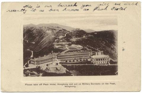
The handwritten note along the top of the card says:
This is our barracks you will see until recently it has been known as Peak Hotel
The soldier who wrote on it was mixing up this building with the real Peak Hotel that stood where the Peak Galleria is today. It wasn't his fault though, as the printed caption reads:
Please take off Peak Hotel, Hongkong and put on Military Barracks on the Peak, Hong Kong
!!!
It's hard to know which is worse:
- That the printer took the publisher's instruction and just printed it word for word, or...
- That when the publisher received the batch of mis-printed postcards, he still sold them to unsuspecting soldiers!
Turning the card over we see that the publisher in question was M. Sternberg.

Further reading:
The Gwulo website has more facts and photos for:
- Barker Road [1898- ]
- Mount Austin Hotel [1891-1897] & Mount Austin Barracks [1897-????]
- Tor Crest [1890-????]
- Meirion [1890-1953]
- Bahar Lodge [1890-????]
- Lugard Waterfall
- Haystack
- Umbrella Seat
- The Peak Hotel (2nd generation) [1890-1938]
- Moritz STERNBERG the man, and M. Sternberg his postcard company
And if you have copies of my books, you'll find more stories and photos from the Peak in Volume 1 (photos 2 & 3), Volume 2 (photos 15 & 16), and Volume 4 (photo 5).
Gwulo photo ID: A623
Comments
Re: Query on Extension to Hotel
Sale of Mount Austin Hotel - China Mail 29 May 1897 refers:
"More than two years ago, rumours were current that the military authorities had cast longing eyes upon this splendidly situated building, but the negotiations were understood to have fallen through because the authorities could not come to terms with the proprietors, Messrs J. D. Humphreys & Son. Since that time extensive alterations have been effected upon the hotel, a large new wing of bedrooms, which was completed only a few weeks ago, and a large ballroom, have been added to meet the growing demands of the Peak District."
The plan was for the military authorities to take over the Hotel in November 1897 Until the new military hospitat on Bowen Road was completed, the Mount Austin Hotel would function as a barracks as well as a temporary hospital.
So I guess the original photo was taken sometime between 1891 and 1895.
Mystery Building
Hi David,
Old Peak photos are a particular favourite of mine, so thanks for posting.
I wonder if your mystery building could be the small hut in the middle of this pic?
It was taken from the reverse angle of yours, albeit much later. Whilst the hut was in approximately the same position as the mystery building, it appears to have a flat roof whereas the mystery building has a pitched roof. That difference may not be problematic as typhoon damage to roofs was common in those days, sometimes to the extent of requiring an entirely new roof rather than just a patch up.
Emerging from near the left end of the huts roof is a light coloured shape that could be a chimney, although it's too blurred to be sure. If it is a chimney, it was in approximately the same place as the chimney on the mystery building.
I think the roof of the hut is also partly visible in this photo.
It's white in colour, just to the left of the bottom left corner of 10 & 11 The Peak (one building, the big one nearest the camera). Again, what seems to be a chimney can be seen at the same end of the huts roof.
If the mystery building and the hut are one and the same, then what was its function? At the time your pic was taken, and for many years afterwards, Haystack was the nearest building to the hut and the frontal shot of the hut shows a path leading to it from Haystack. The hut was therefore probably an outbuilding of Haystack. The front of the hut has two identical doors and windows, suggesting it was divided in half internally and that each half was rather small. Perhaps it provided additional storeroom or quarters for staff of the Haystack, e.g. groundsmen/gardeners?
Would it be possible to blow up the part of your photo showing Victoria Gap to assist in dating your photo? Peak Hospital, Peak Hotel and Formosa were all developed around the relevant time and may provide clues if they can be seen clearly.
Again, thanks for yet another interesting post.
Re: Query on Extension to Hotel
Thanks Moddsey, that newspaper article is just what I was looking for. It says the new wing (shown on the left below) was finished a few weeks before the date of the article, so around April / May 1897.
re: Mystery Building
Thanks GW, that's a match. So as you say, likely just a little hut for people working at Haystack.
I've uploaded the enlargement, and will keep my fingers crossed that you can glean more clues about the photo's date:
1890s View from the Peak
Thanks for the enlargement David. I think your photo can now be dated to before mid-1893. Here's why.
Your enlargement reveals the corner of a building sticking out from behind the slope of Mount Austin. I've ringed it below.
I think it's the Engine House at the Upper Terminus of the Peak Tram. Here's a better view of it in which it's the brick building nearest the camera.
Later photos show a second building at the Upper Terminus, just downhill from the Engine House and next to where the tram platform appears to be in the photo above. It's the building nearest the camera in this pic.
And it's the building with the two-level roof in the next photo in which I've ringed the Engine House again.
The 1909 and 1912 Peak maps (https://gwulo.com/atom/14774 and https://gwulo.com/atom/13074 list the new building as the Tramway Managers House. The 1924 Peak map (https://gwulo.com/atom/13017) labels it as the Tramway Station House and tells us it occupies Rural Building Lot (RBL) 80.
RBL 80 was put up for sale by auction on 8th May 1892 (Government Gazette Notification 190/1892). Unfortunately I can't find any record of whether the auction was successful. However, one of the requirements for any buyer was to construct a substantial building on the lot within one year of the auction and just a few months later, at the 8th Ordinary General Meeting of the Hong Kong High-level Tramways Co. Ltd., it was reported that;
"Arrangements have been made with A.S. Watson and Co. Ltd. to erect a building adjoining the engine house, a portion of which is to be leased to the Tramway Company so as to afford go down, waiting room and other accommodation which is much needed" ( China Mail, 13th December 1892).
The 1893 meeting was informed that the work had been completed (China Mail, 21st December 1893).
I am not aware of any other building being erected "adjoining the engine house", so presume that the building being referred to was the one on RBL 80. Assuming that a substantial building would take at least six months to complete, site preparation must have commenced by mid-1893. Therefore Davids photo must have been taken before mid-1893.
I've made enough mistakes in the past to know that there may be something wrong with the above arguement. Corrections welcome.
1891 - 1893
Thanks GW, that narrows down the range of possible years even further.