Current condition
Ruin
This is one of the three pavilions found on the knoll behind Tiger Balm Garden. There are broken steps between them, and numerous glass bottles are found among debris at the lower part of the slope.
For the exact location of this one and the one further downhill, please check the Geo Info Map online, they are shown in the large scale version of the Map. https://www.map.gov.hk/gm/geo:22.2739,114.1954?z=1361
This one is at the lowest level, near Tai Hang Drive.

This is the one in mid-level of the hill.

Photos that show this Place
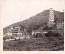
c.1940
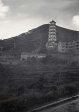
1946
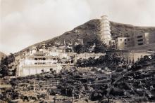
1947
Comments
Pavilion
Wow! Nice find.
Re: Pavilions
Not sure if the pavilions are connected to the Tiger Balm Gardens. There are many photos taken from the top of the hill looking down at the Tiger Pagoda. I also note there are trails leading uphill.
See here and the comments
See here and the comments attached:
Found the one further uphill
Found the one further uphill near the top today with reference to this link, one has to be in the satellite layer and the street map layer at the same time in order to be able to view the content:
https://maps.app.goo.gl/K1fKXBFaBorkpsWE8
Rear
Side
Maps of Tiger Balm Garden, and view from the lower pavilion
Hi H Lo, great find! Thank you for sharing. I am quite sure the three pavilons you found were part of the Tiger Balm Garden. How else would one explain their very existence on a barren hill? There may be more remnants of the garden up the hill and on the eastern boundary.
There is a pair of 'before and after' bird's eye view drawings (one on a semi-transparent plastic page) in the book Tiger Balm Gardens: A Chinese Billionaire's Fantasy Environments by Judith Brandel and Tina Turbeville. At least one pavilion is shown on the drawing.
'Before' drawing
'After' drawing in 'The 'real Garden' section -- This was after the top part of the garden was demolished for the building of Ronsdale Garden in the 1980s. This was the time that the pavilions became 'orphaned'.
This image on Flickr shows the view from the lower pavilion. The same photostream has more photos of the Tiger Balm Garden.
Nice view of all three pavilions.
Here's the government map of
Here's the government map of the area from 1960, showing the pavilions, paths, and squatter huts (marked "Temporary Structures") at that time: https://www.hkmapservice.gov.hk/OneStopSystem/map-search/getPreviewFile…
That website is very slow, so you may have to wait a few minutes after clicking the link before you see the map.
I don't think that the Tiger
I don't think that the Tiger Balm Gardens ever reached so far up the hillside even as far as the lower two pavilions. It is of course possible that the Haw family built the three pavilions up on the hill so that they, and presumably others(?) could enjoy the view down to the gardens. Is there any indication as to the age of the pavilions? Is it even possible that they were built by the Japanese? Whatever, it is quite remarkable that they have survived without apparently being converted into temporary dwellings as happened to so many of the military structures around the island.
Yes, the pavilion at the
C,
Yes, the pavilion at the lowest level can be seen in the 'Before' drawing.
The Flickr photo was taken from the above mentioned pavilion.
Is it possible to find out who owned that hill or that region during the 40's?
David,
Thanks for the map which shows all three pavilions, the present Geoinfo map only shows two of them.
No current lots on hillside of former Tiger Balm Garden
Thanks H Lo.
I looked at the online GeoInfo map and there are no lots on the hillside where the pavilions are. I am not sure whether the land was resumed by the government at some point.
The Lands Department has an online tool but I cannot figure out how to get historical lot information. The link is:
https://www.landreg.gov.hk/en/services/services_b.htm
Re: Pavilions
It is noted there were trails/paths from the lower levels of the Tiger Balm Gardens to the pavilions at mid-levls and the summit post WWII, I assume the pavilions are related to the Gardens. The structure of the pavilions look similar to pavilions in the Gardens. I don't think there can be any other explanation for the development of the hillside.
I'm trying to ask those in
I'm trying to ask those in their 60's ... etc. if they have any ideas of such, however, for people of those ages, some of them are not born and raised here. For the rest, they might not be living on HK island. People in those days were often unable to afford traveling for leisure with their families, some of them told me that it's rare that they had the chance to cross the Harbour, especially for those living in the N.T.
A lady in her 50's living at the Wun Sha St vicinity can only remember playing at the stream (Tai Hang). She can also recall memories of the squatters area beside Tiger Balm Garden, but nothing beyond that ... I am wondering if that hillside was already covered by trees instead of undergrowth which left her no pictures of the pavilions in view.
Re: Pavilions
I agree with moddsey.
I think it is useful to ask those who lived in the vicinity to provide information. The pavilions were not surrounded by walls so people might have visited them and the hill.
As for the stream beside the Garden, the bird's eye view depicting the Garden in the 1940s shows some structures around the stream. I wonder if remnants still exist.
I have been taking the path
I have been taking the path next to the stream once or twice, traversing the ruins of the squatters area. That path connects Tai Hang Rd and Sir Cecil's Ride.
Tai Hang Gorge 1946., by Jack
This photograph from Jack Cubitt's 1946 photographs in the 367 Association gallery shows more or less the same view as that taiken by Malcolm Trousdale in 1951/3. Malcolm's clearly shows a pavilion on the top of the hill but it is not clear whether the faint outline on Jack's photograph is a pavilion or just a smudge. Even allowing for a slightly different standpoint, it seems to be a bit too far to the right and lower down than the pavilion on Malcolm's photograph, which looks to be on the summit. If it is a smudge and not a pavilion, it would seem that the top pavilion might well have been constructed some time between 1946 and 1951/3. I still feel that the top pavilion, especially as seen on Malcolm's photograph, was far too high up on the hillside to have been part of the Tiger Balm gardens - athough it might have been constructed by the garden's owners at a time when there might not have been much control over such things. Andrew
A Book Reference
The Tiger Balm Garden site is mentioned here in "Landscapes Lost and Found: Appreciating Hong Kong's Heritage and Cultural Landscapes" from Page 21 onwards. Unfortunately, there are some missing pages in the book review.
Thank you Moddsey for
Thank you Moddsey for providing such an interesting link to the history of the garden. I read it very carefully but still have my doubts whether the three pavilions very high up on the hill were part of the garden. On page 22 the document is very specific in stating that 'the site was only about 1.2 hectares in area.' That is fractionally under 3 acres (2.965), being about 100 x 120 metres - the size of what everyone knew to be the Tiger Balm Garden. So, I suggest that the garden did not actually go outside what we all remember. On page 23 and 24 we read 'Careful siting of moon gates and openings in grottoes provided the visitor with borrowed views of the wooded hillside across the valley, making the garden seem larger and more vegetated than it really was. Clever use of small pavilions on top of the slope created a false perspective that made them look more distant when viewed from below.' I believe that these pavilions were probably miniature ones actually high up within the boundary of the garden but cleverly used to give added perspective. 'Forced perspective' is what this is sometimes called. My strong suspicion is that the three pavilions way up on the hillside especially the highest one are something very different. It is certainly an interesting mystery! Andrew
Agree
Agree that the three pavilions are not specifically mentioned in the book. I did note however that the "original site was relatively inaccessible".
Tiger Balm Gardens book
Thank you everyone for the input. The book Tiger Balm Gardens: A Chinese Billionaire's Fantasy Environments by Judith Brandel and Tina Turbeville is so far the most detailed book on the Gardens in Hong Kong and Singapore, and it may well contain some clues on these pavilions. The bookl should be in libraries and is available from the Aw Boon Haw Foundation.
Then maybe we can contact
Then maybe we can contact this Foundation enquiring them regarding any possible information on those pavilions. I have already done so, pending their feedback.
This section of a map that I
This section of a map that I bought in 1958 does show that the Tiger Balm Garden (marked with a pagoda just off centre) was some way from the major East / West road at Causeway Bay. I accept that this map is not as accurate as the Ordnance Survey ones but I recall having 'a long way' to walk up the Tai Hang road from Cauesway Bay - and we were young and fit! Perhaps many tourists wanting to see the famous garden would find the lack of easy access by tram or bus quite 'daunting' and maybe that's what the book was getting at?
Re: Then maybe we can contact
Hi H Lo,
It is worth trying, but I doubt if the Foundation would have the information we want. I went there to purchase the book (which, unfortunately, is not with me now) and only saw one staff member there. It may be better to try to get the contact information of the two authors of the books, and ask them.
By the way, the book was first published in English. A (translated) Chinese edition was published a few years afterwards.
Re: TIGER BALM GARDENS A Chinese Billionaire's Fantasy Environme
Hi There,
US$55.- is reasonable. Saw an entry at Amazon US offering the hard cover version for US$449.25 plus US$25.95 shipping used, claiming very good condition. That's a rip off if the Foundation still have stock for the hardcover.
T
Tiger Balm Gardens book
Hi tngan,
Wow, that is outrageous! The Foundation likely still has stock. I think I have seen copies in the Hong Kong Book Centre several years ago.
1: someone reminds me that
1: someone reminds me that the pavilion with the balustrades can be found in older versions of the country map (1:25000).
2: emailed to the Foundation for over a week, got no reply so far, maybe it has been in the junk mail box all the time.
Re: Country side map
Hi there,
The map you just uploaded showed the current shape of the Hong Kong Stadium. I checked one of my older maps (1990 version) and it still showed the old Government Stadium shape. Guess your map must be later than 1994.
I don't even remember the Tai Hang Drive already exist back 1990. But that means, the foot paths to the pavilions had already been cut off when Tai Hang Drive was built.
T
Pavilions and Tai Hang Drive
Hi H Lo and T,
I think Tai Hang Drive was built to provide access to Ronsdale Garden that was completed in 1986 on land that was part of the Tiger Balm Garden.
It may be more efficient to just phone the foundation, or even drop by during office hours. In such as case you can browse both the English and Chinese editions of the books, and perhaps talk to people who know something about the Garden. I find that e-mails and Facebook messages are not readily answered by many organisations in Hong Kong, but of course the sample size of my experience is relatively small.
Is yours a topographic map of
tngan,
Is yours a topographic map of 1:20000?
No pavilion is shown on it ...
Wow, haven't ever thought that those hiking pals still use such an old version nowadays, so it's either 1994 or afterwards ... Will confirm with them if ever meet them again.
C,
Yes, will try to remember to pay a visit one day when I happen to be in the vicinity.
ABH Foundation
Hi H Lo,
Better call them beforehand to make sure there is someone there when you go...
Re: HK Island plus Po Toi Island Map.
Hi Lo,
The title page reads: Countryide Series Sheet No. 1, Edition 9, (1990). 1:20,000.
I have a more recent set somewhere in the pile or still in my hiking bagpack, maybe dated 2004 onwards, which may as well be a bit outdated.
I have to admit, old maps sometimes contains information that the Map Office decided they are no longer required. Like those Footpath numbers I mentioned in another thread. I found those on Countryside series Sheet No. 1, 4th Edition, dated 1975. (which caused just HKD3.- back then)
Just took a peep and confirmed, Tai Hang Drive had not been extended to today's status yet. It stopped by just completed the S bend. There were foot paths in the map, but no pavilions on the slopes. This map is 1:25,000 and is still using Imperial System.
T
True, the old maps got more
True, the old maps got more information, perhaps it has to make way for new information in recent maps, or that the staff are not sure if the old information is correct anymore, so they'd rather remove it. Yet, sometimes certain information that we need which still exists is removed this way too.
Dam at Haw Par Stream
Here is a page with a photo of a dam nearby. I wonder if there are more remnants of the garden in the area, waiting to be re-discovered.
Pavilions
The area where the pavilions are was probably not used or visited by Tiger Balm Garden guests. In 1980 already the slope looks unoccupied and trees and bushes start to grow. In this photo, I can only spot the top pavilion, the others are probably overgrown already.
Pavilion above Tiger Balm Garden
An interesting photograph Klaus. My memory of that hillside above the Tiger Balm Garden in 1957/8 is that it was certainly quite barren, and that the lower parts close to the garden were covered in squatter huts. I visited the garden once, maybe twice, but its boundary was quite close in to the house and the statuary, and I still have serious doubts as to whether the garden actually stretched up the hillside. Historical evidence on Gwulo suggests that plots of land were always controlled quite strictly by the authorities, so I have a feeling that any pavilions erected up there were possibly very unofficial. However, on this photrograph taken by Jack Cubitt in 1946, it does look as though a pavilion is visible at the top of what looks like a short zig zag path in the centre of the image. Could that area have been a more natural extension of the garden? There might also be another pavilion at about two o'clock from that one. Then, moving slightly further to the right and a bit lower are clear signs of some terraced fields just above some of the statuary and another of the pavilions actually in the garden which have been described elsewhere as being built deliberately on a small scale in order to add 'depth' and 'size' to the garden.
Pavilions
It looks to me as if there is something like a viewing terrace around the middle pavilion.
Yes, that would seem to be
Yes, that would seem to be the case. I still find it odd that, no matter how prosperous the Aw Boon-Paw family was, they could have received permission to extend the property's land and build pavilions up there, especially the one at the top of the hill as is visible just to the left of the pagoda's top. That is a huge area of land. Is it possible that the Japanese, who would not have been at all constrained by property rights, could have built them?
Another guess
The homepage of Haw Par Mansion refers:
Adjoining the Mansion and its private garden was the landscaped Tiger Balm Garden, opened in the same year for public enjoyment and has since become part of the collective memories of generations of Hong Kong people.
Obviously, a private garden existed that was not open to the public.
In the Hong Kong Sunday Herald from 1936-07-19 a report is given about "Mr. Aw Boon Paw's new home in the colony". Presented there were the villa itself and the garden.
Situated as it is on the top of the Tai Hang hill, it commands a good view of the eastern portion of the harbour, while it overlooks Tai Hang itself, including the old polo ground.
On the neighbouring hillside are the thatched village huts to remind one that in Hong Kong there still many may be found remainders of ancient China.
So the latest guess would be that the pavilions were part of the private garden of Haw Par Mansion.
Klaus,
Klaus,
The pavilion at mid-level has a railing with balustrades, and its the only one having that. The one near the hilltop was built on top of a giant rock pillar, it's a bit dangerous to be strolling around, I wonder if there used to be some kind of railings for this one.
1950s Tiger Balm Gardens
Rummaging through old photos. An aerial view I think of the mid-level pavilion at the rear of the red pagoda ?
Fantastic! That's the one at
Fantastic! That's the one at the lowest level (alt. 130), it's so close to the Garden, without any fence or railings separating them.
Looks like the steps on the right almost reached the level walk above ...
Only the large scale shows the lower two pavilions, it seems to me that the slopes looked quite different from how it was. From the photo, that pavilion seems to be situated on a knoll, whereas it's just not the case at all.
https://www.map.gov.hk/gm/geo:22.2739,114.1953?z=1260
Re: Pavilion
Thought the lowest one was closer to the main Tiger Pagoda whereas the one at mid-level was closer to the Red Pagoda as seen here
I note the "Clever use of small pavilions on top of the slope created a false perspective that made them look more distant when viewed from below."
Lower pavilion
This has to be the lower pavilion because this was the section of the garden that was removed to make way for Ronsdale Gardens and Tai Hang Drive.
Pavilion
The 2 small pagodas and the pavilion in the photo here seem to be more or less at the same elevation and similar distance apart. It's unlikely the same pavilion in the other photo. It can be seen in this drawing.
Re: 1950s Tiger Balm Gardens
I agree with tkjho. It is more apparent in the two photos posted by Klaus.
By the way, I believe the pagoda on the left in the photo posted by moddsey is the tomb of AW Chu Kin (胡子欽), father of AW Boon Haw (胡文虎) and AW Boon Par (胡文豹).
Hi Everyone,
Hi Everyone,
I have enjoyed reading all your contributions and seeing more detailed photographs and pictures showing the two lower pavilions. You have convinced me that they were certainly in a remote and not generally accessible part of the garden in the mid 1950s, when I first visited the garden. The topmost pavilion remains a bit of a mystery as it still seems to be much higher up on the rocky hillside. So, my tentative suggestions that they were built unofficially by the family or even by the Japanese are now redundant! The only thought that I still have is that the two(?) pavilions shown on H Lo's recent photographs don't show 'miniature' ones but structures that look even larger than the umbrella seat canopy on Mt Austin Road. Any thoughts? Regards, Andrew
pavilion
C - my understanding is it was a memorial rather than the actual tomb, but I'm not certain.
In hindsight I think I agree about the pavilion. Perhaps the one in Moddsey's image also disappeared following the Ronsdale Garden development?
For easy reference, here
For easy reference, here are the records of altitudes of the 3 pavilions in my app:
~154m, ~?m, ~192m (forgot to pin the marker for the mid-level one, only estimated the location according to the route I made, cos I have been moving about the place taking pictures). But then a new mystery arises, for if the two squares on the GeoInfo Map are the lower two pavilions, then my GPS for the altitudes may not be working properly, it's likely to be the case, for I was too close to some tall buildings, my signals might not be that accurate. Only the topmost one has a proper record since I was farther away from those tall buildings downhill.
Legend: L - lowest, M - mid-level, T - topmost
The green arrow points at the boulder-like legend of which I wonder if it is the pavilion instead, cos it has a triangular roof, and is standing beside a rock pillar or a giant boulder with a sheer drop on its north face.
Re: Geo Info Map
Thanks for the Map. Yes, the photo I recently posted does show the lower pavilion and trail/path leading to the middle pavilion on the right.
A Heritage Impact Assessment on Haw Par Mansion can be viewed here A wealth of information is given and the leased land extensions to Haw Par Mansions between 1936 and 1939. Not sure if the land extensions refer to the hillside areas behind Haw Par Mansions or just the main building itself.
Unfortunately, pre-WWII photos are scarce and do not clearly show the pavilions. A photo from 1938 here
However, this photo here from September 1945 does show the pavilions.
After checking details on
After checking details on this screen capture of a photo from this site
https://zolimacitymag.com/haw-par-mansion-and-hong-kongs-lost-chinese-f…「Tiger Balm Garden and Haw Par Mansion in the 1950s. Photo courtesy University of Hong Kong Libraries」, I have circled the mid level and lower pavilions in red. On the other hand, those two pagodas which can be seen in the aerial photo you posted are circled in pink.
In view of this new discoveries, I believe the pavilion in the aerial photo isn't the lower pavilion, instead, it may be something of similar design.
Just called the Foundation
Just called the Foundation over the phone, the lady answering it believed that the slope where the pavilions were didn't belong to them. However, as she has no idea there is Tai Hang Drive with the Green minibus terminus, I am wondering if she really get what I am enquiring about, so if you have any other questions to put to the Foundation, maybe you may ring up for enquiry.
At about 1:22 of this video, one may catch a glimpse of the pavilions.
Old video
If this Video is can be shown at a slower speed, we may be able to see the pavilions ... I seem to be able to see the topmost one near the last part of the video.