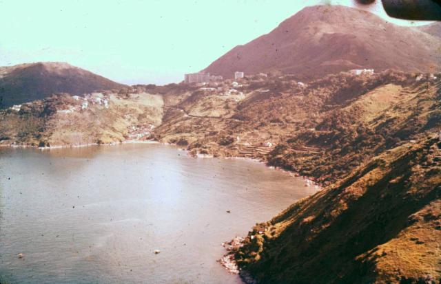
Taken while Ken was flying a light aircraft, the starboard propeller being just visible at top right. Can anyone identify that part of the coast? I think it was probably somewhere on the West side of the island, probably in the Pokfulam area. Andrew
Date picture taken
1960 (year is approximate)
Gallery
Shows place(s)
Comments
High West
Hi There,
That looks like High West on the upper right. The very BIG building looks like Queen Mary Hospital while the hill on the left hand side looks like Mount Davis.
T
Coastal Scene
Thanks to Tngan for identifying the photograph as having been taken from over the sea looking towards High West and Mt Davis. This Google Earth Street view image shows more or less the same view.
This is telegraph bay
This is a very nice photo of Telegraph Bay and not Sandy Bay. Sandy bay is next to Telegraph Bay behind the little peninsula sticking out to the sea on the left side of the photo. From the shading of the sun, looks like the photo was taken in mid-morning. Also, the photo was taken in the early sixties or earlier when this pristine area of Hong Kong Island was still mostly owned by Dairy Farm and had not been “urbanized.” The tall building in the middle of the photo is Queen Mary Hospital and the building at the same elevation as Queen Mary Hospital, but on the right side of the photo is the University of Hong Kong’s University Hall. The mountain behind is, of cause, High West, and the hill on the left side of the photo is Mount Davis. Victoria Road can be seen hugging the coast at a lower elevation. Further up the slope close to Queen Mary Hospital is PokFuLam Road but there are just too many trees blocking the view of the road. This Telegraph Bay area has since been reclaimed and now it is where the high-tech Cyberport is located.
Thank you WYIP. I have…
Thank you WYIP. I have amended the appropriate items associated with the aerial image.
Follow up
Thank you for sharing this photo with all the readers on the Gwulo website. Aerial photo of the west coast of Hong Kong Island in the fifties and early sixties is very rare. The western slope of High West was a sleepy little town consisting mainly of Queen Mary Hospital, Chinese Christian Cemetery, Dairy Farm, and a couple of villas occupied mainly by westerners at the end of Sasson Road. There were two sleepy little farming villages, one in Sandy Bay and the other in Telegraph Bay. The main reason the Chinese did not want to move into this area is mainly out of superstition. The cemetery and the hospital are not what the Chinese would like to live next to, despite the tranquility and breathtaking sunset view. Development did not come about until around 1961 when the HK Government decided to build the Northcote Teacher Training Center at Sasson Road. This was followed by other residential developments there. Another development boom came in 1966 when the HK Government Housing Authority selected a coastal area south of Telegraph Bay and developed it into the Wah Fu Housing Estate. From then onwards, the floodgate was opened, and more private developers started to build apartment complexes along Victoria Road. People seem to have forgotten there is a cemetery and a hospital nearby!
Again, thank you for posting this photo on the internet for me to reminisce.