Completion date approximate. Both dates taken from the Offbeat Magazine article:
((The first)) No. 8 Police Station, located in Station Street, Tai Ping Shan District, gave the street its name. In use from 1870, the station had to be moved to the nearby Hospital Road during re-development of the Tai Ping Shan District in the late 1890s, immediately after the bubonic plague epidemics. ((ie the second generation)) It was demolished in 1925. A new No. 8 Police Station ((the third)) in High Street was inaugurated in 1928 and then demolished in 1934. The fourth No. 8 Police Station was built on the same site and was completed in late 1935. It now houses the Crime Hong Kong Island Regional Headquarters.
This page refers to the second generation. We have pages for the first generation at http://gwulo.com/node/32521, and the third generation at: http://gwulo.com/node/9098


Comments
I've set the completion date
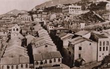
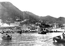
I've set the completion date for this building back to unknown. I'd previously set it as 1895, based on the Offbeat article shown above, but the two-storey building appears in the c.1870 photo shown above.
I guess that the Police had to find a new location at very short notice once Tai Ping Shan was evacuated after the plague, and so moved to this existing building nearby.
I'm not sure what it was named or used as before it was a Police Station.
The 1924 map shows this is lot IL 598.
Seems that the police station
Seems that the police station move didn't have anything to do with the plague.
I890.—Purchase of Inland Lot No. 598 with the Premises erected thereon, for Police Station: $34,000
Source here:
Perhaps they just needed a bigger premises as the first location was very small
That's an interesting find,
That's an interesting find, and as you say it shows they'd already decided to make this a police station long before the plague hit HK.
I stand to be corrected,
I stand to be corrected, (perhaps someone can help out here), but I think the 4th station on this site was pulled down for construction of the MTR station at this location.
This was the station to which George Wright-Nooth was posted when the Japanese captured HK, and he gives an wonderful description of surrendering to them at Christmas 1941 in "Turnipheads."
Incidentally, Mike Watson's & Crisswell's book gives an excellent history of all of HK's Police Stations from 1844 up to WW2.
4th generation site & MTR
We've got a page for the 4th generation site a bit further west on Hospital Road, see:
http://gwulo.com/node/8579
That building was redeveloped to become the new David Trench Rehabilitation Centre.
The old David Trench Rehabilitation Centre on Bonham Road (see http://gwulo.com/node/32550) was demolished during the MTR line work, and there's an entrance to the Sai Ying Poon MTR station there now.
Regards, David
Demolition of the 2nd generation of No.8 Police Station
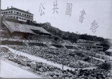
The building was demolished in the first half of 1925, with the intention of constructing a new No. 8 Police Station on the same site (see point 110 in the 1925 PWD AR). However in July that year there was a major landslide (see https://gwulo.com/node/38024) when the retaining wall at the front of the site collapsed. That ended plans to build a police station on this site, and instead the Police Station moved into a building on Hospital Road, see: https://gwulo.com/node/9098.
Caine Lane Missing
Any reason why Caine Lane was not shown in the map? I know it used to connect to Caine Road at the junction with Ladder Street. Does anyone know when the disconnection happened and why?
Regards
David
re: Caine Lane Missing
It looks as though that's a mistake in the ESRI map. If you choose another map the connection to Ladder Street is shown, eg:
https://gwulo.com/node/20883#18/22.28349/114.14834/Map_by_Thunderforest-Markers/100