Named after: Sir Matthew Nathan, Governor of Hong Kong (1904-07)
Timeline:
Nathan Road was developed in several phases.
- c.1865: Street first laid out.
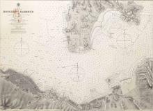
A comment below links to an article that notes construction began in 1865. - 1888: The earliest map at http://www.hkmaps.hk/mapviewer.html that shows any part of this road is the 1888 map. It shows the southern end of the road was roughly where the junction with Middle Road is today. At that time it was a sandy beach at the southern end of the peninsula. The road ran north in a straight line along its present route til it reached today's junction with Austin Road. From there the road continued north then west to Yau Ma Tei, but following a different course than the modern road.
- 18??: Street named
Originally it was named Robinson Road. Of course there was also a Robinson Road on Hong Kong island, so this would cause trouble later. - 1???: Street extended north from Austin Road to Market Street
- 190?: Street extended south across the newly reclaimed land, to reach the junction with Salisbury Road.
- 1908: Street extended north from Market Street to Waterloo Road (see point 76 in PWD 1908 AR)
- 1909: Street renamed.
The name changed from Robinson Road to Nathan Road. (The announcement appeared in the March 1909 issue of the Gov't Gazette. "Nathan Road" is also used in the PWD's Annual Report for 1908, but that was only completed in May 1909, after the Gazette announcement.) - 1909: Street extended north from Waterloo Road to Kowloon Farm Lot 2 (today's Soy Street, see point 79.ii in PWD 1909 AR.)
- 191?: The section north of Waterloo Road became Coronation Road.
- 1926: Nathan Road absorbed what used to be Coronation Road, and the Coronation Road name was dropped. (See Item 329 in the Gov't Gazette for June 18, 1926, which announces the numbering of buildings along Nathan Road north of Waterloo Road, "formerly Coronation Road".) The northernmost point of the extended Nathan Road road in that document is some Crown Land north of Mong Kok Road.
- 19??: To be continued ...
Other points of interest:
Current condition
In use
Photos of this street:
(see more)Photos of this street:
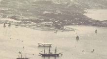
1886
1888
1888
Comments
Construction date 1865
An interesting find by moddsey regarding Haiphong Road:
Haiphong Road is one of the few roads in Hong Kong not named after Chinese or British cities, counties or provinces. Instead, it was named after a northern Vietnamese port in 1909, when dozens of streets in Kowloon were renamed after cities that had close commercial ties with Hong Kong. Before then, it was known as Elgin Road after Lord Elgin - the British plenipotentiary who officially received Kowloon from Qing officials in Beijing in 1860. He in turn handed Kowloon over to Governor Robinson of Hong Kong. Five years later, when Tsim Sha Tsui was still what its name means - a sharp sandy spit - two roads were laid out on the peninsula: Nathan Road (originally called Robinson Road after the governor), and Elgin Road (now Haiphong Road), the shorter road leading off it.
So it looks as if Robinson/Nathan Road was built in 1865 already.
re: Construction date 1865
Thanks Klaus. I've deleted the original "c.1888" date I had for the original construction of the road. It'll be good to see some more evidence of the c.1865 date before using that.
Construction date
Hi David. Probably it was better to hesitate as I found an article by Tymon Mellor on industrialhistoryhk.org about Hong Kong Roads:
In Kowloon, by 1887 a fairly comprehensive road system was in place south of Austin Road. The first 850 metres of the 30 metre-wide Robinson (Nathan) Road from Middle Road, some 1.1 kilometres of MacDonnell Road (later Canton Road), and Des Voeux Road (later Chatham Road) were all started. Many of the intersecting roads, for example Granville and Kimberley Roads, were already built. To the north of Austin Road the road network was concentrated in the southern Yau MaTei district with the 15 metre-wide and 1.6km-long Station Road (later Shanghai Street) reaching Mong Kok Tsui. A small independent road system had already been constructed in the Hung Hom area near the docks, for example Bulkeley Street and Gillies Avenue.
By the turn of the century there were some 35 kilometres of roads in Kowloon which included the first two original direct links into the newly-leased New Territories, that is those to Kowloon City and the Tong Mi area. In particular the road network in the new development at Yau Ma Tei was well under way and the Hung Hom road system had been enlarged and connected to the extension of Des Voeux (Chatham) Road.
.......
The main road network in Kowloon continued to expand with Sham Shui Po being linked to then existing road system in 1916 with a 6 metre wide 700 metre long road, part of which was formed on a 3.4 metre high embankment. The first section of Waterloo Road, Argyle Street and much of Prince Edward Road were completed by 1924. At this time, Nathan Road had been already extended by Coronation Road (later also part of Nathan Road) nearly up to the old boundary.
Construction date
David, I'm trying to find more information on the construction year. There is a map from 1863:
As you already said, this is obviously more a general idea on possible roads than existing or planning ones. Possibly this map led to the idea that Nathan/Robinson Road was constructed that early.
Another map from 1897 shows Robinson Road, but that doesn't help with fixing a date:
1905: Extension to the south
1905: Extension of Robinson Road between Middle and Salisbury Roads
Source: 1905 Public Works Report, clause 64 , subclause iii
1904/5: Extention to the north
In the Public Works Report for 1904 under clause 78 is reported:
Portions of certain Lots were resumed in connection with this extension of Robinson Road, viz., Kowloon Inland Lots 1011, 69A, 79, S0 and 81, and paid for from special votes.
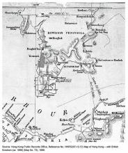
These lots can be seen on the 1896 map on Gwulo (blue line marks Robinson/Nathan Road)
The new road cuts through these lots (note: on this map I.L.1110 is designated as I.L. 58).
The 1905 Public Works Report under clause 65 is reported:
65. Kowloon Roads.—Two contracts were undertaken out of this vote ; one for lowering the summit of Robinson and Austin Roads, extending the former to the Yaumati Theatre and completing that portion of Gascoigne Road between Robinson Road and Station Street; and the other for forming roads in the vicinity of the Disinfecting Station. Both works were nearly completed at the close of the year.
window.parent.CKEDITOR.tools.callFunction(158,this);
Robinson/Nathan Road - early evidence?
Construction start 1865 confirmed
From Historical and Statistical Abstract of the Colony of Hong Kong 1841-1930
Public Works 1865 : .......
Battery Road laid out at West Point and first sections of Robinson and MacDonnell Roads in Kowloon.