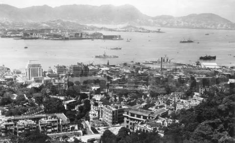
When: A couple of clues say this photo was taken not long after the end of WW2. First there's the blotchy appearance of the Peninsula Hotel, still wearing the camouflage paint applied during the Japanese occupation of Hong Kong.
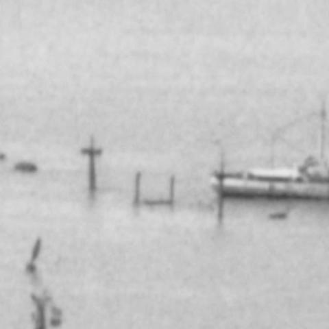
Second are these masts sticking up from the sea, and what looks like a salvage boat working next to it. The masts belonged to one of the many ships sunk by American bombers during the war.
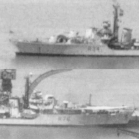
Other clues for the date are the two Royal Navy C-class destroyers.
Out in the harbour is R34, HMS Cockade [1], then back in the dockyard's tidal basin is its younger sister R76, HMS Consort [2]. HMS Consort wasn't commissioned until March 1946 so this photo must have been taken after that date. I'll guess mid-1946, but if you can give a more accurate date please let us know in the comments below.
|
Gwulo in London: Talk on 20th February, 2016 |
What: We often see this in post-war photos of the harbour.
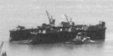
I'm pretty sure it is a floating dry dock, but I'd be interested to know where it came from, and what it was used for. We can see the dry dock at the Naval dockyard was already working again as it has a ship in. Then why the extra floating one?
Was it originally part of the preparations for the invasion of Japan that got re-deployed to Hong Kong after the end of the war? You can imagine them having lots of surplus useful equipment that needed a good home.
Or was it part of the salvage operations to recover the wrecks from the harbour? Could they float a wreck high enough to bring it in to the lowered floating dry-dock, then raise the dry-dock to work on the wreck and patch it up?
These are just my guesses, so please put me straight if you know more about it.
Who: Down in the centre foreground, the photo shows two groups that were affected by the war years.
Let's get our bearings first. The bridge at lower-left is where Macdonnell Road crosses the Peak Tram tracks. Follow the tracks beyond the bridge and you'll see there is a dark-coloured section about half way along. That's the bridge where the tram crosses Kennedy Road.
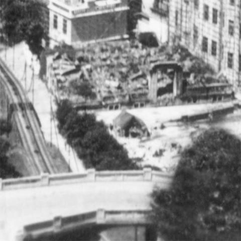
On the downhill side of Kennedy Road are the ruins of a building. From the appearance of the remaining arch it looks to have been burnt down by fire. Before WW2 this was St. George House [3]. Today it's the site of the Freemasons' Zetland Hall [4], replacing their previous building that was destroyed during one of the American bombing raids [5]. I'd wondered how the Kennedy Road plot of land was available for them to build on, and now we know.
Across on the uphill side of Kennedy Road is a bare patch of land that has another mystery. The land belongs to the Union Church [6], and when its congregation was interned in early 1942 the church was still standing. But when they went back to the church after liberation, all they found was a small pile of rubble, and the three dedication plaques from the walls of the old church.
The church's historian says the material from the old church was used by the Japanese in their reconstruction of Government House, but did the Japanese demolish the church or simply make use of rubble from an already destroyed building? My guess is that both St. George House and Union Church were hit in a bombing raid, but again please let us know if you have the facts.
Where: No mystery about this, the card is titled:
H.K. harbour from May Rd.
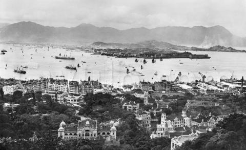
This was a popular view for postcards. Here's one from the 1920s, showing the spire of the old Union Church building, and St. George House beyond. (You can click any of the photos to see a larger copy that you can zoom into.)
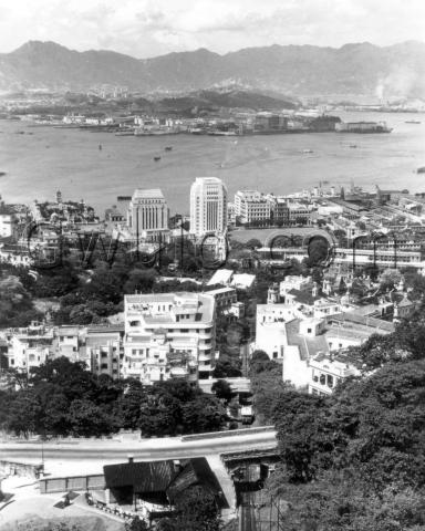
And another from the 1950s after the new Zetland Hall had opened.
Gwulo reference: A360
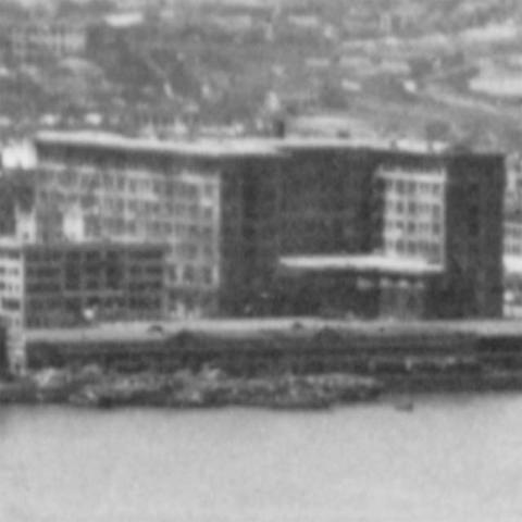
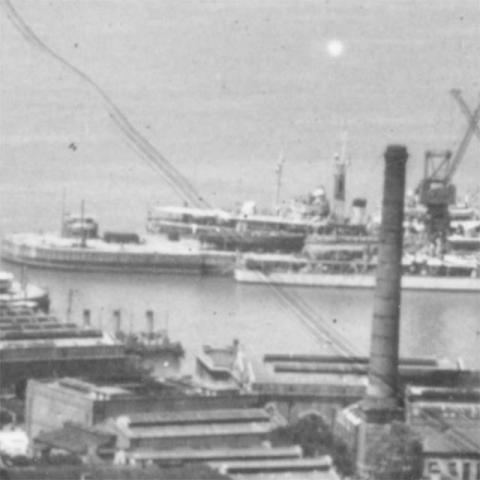
Trivia: This has been a fiddly photo to restore. It looked good at first glance, but once it was scanned and zoomed, there were lots of blemishes to fix. Here's a close-up of the area around the tidal basin, as it looked after scanning.
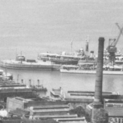
Here are the all the fixes.
And the final result!
|
Also on Gwulo.com this week:
|
References:

Comments
This photo shows a rare clear
This photo shows a rare clear view of the facade of the Old Building of St. Joseph's College, just behind the St. George House/Zetland Hall. Photos from up the hill usually show a building there blocking our view, and only the two towers from SJC poking their heads out the top can be seen. This picture tells us that the face of the Old Building has basically remained the same till today.
Can anyone tell me what that small building sandwiched between SJC and the ruins of St. George House is? It is still standing today.
breskvar
Re: Floating Dock
China Mail 10 and 11 December 1945
The floating dock belonged to the Admiralty and arrived in Hong Kong harbour on 9 December 1945. It was towed from Manus, Admiralty Islands to Hong Kong via Subic Bay by two tugs, Advantage and Cheerly. HMS Hart acted as the escort ship.
More information on the floating dock here and here
After Zetland Hall (in
After Zetland Hall (in Zetland Street, Central) was destroyed by American bombing in 1944 the Zetland Hall Trustees decided to rebuild it on the site of St. Georges House at 1 Kennedy Road. As the following extract from the official history of Zetland Hall explains:
"Bro. Brown then came to the main scheme: to sell the old Zetland Hall site of almost seventeen thousand square feet, to realise at least a million dollars, and purchase the old St. George's Hotel site at 1 Kennedy Road, five thousand seven hundred square feet costing $114,000. In support of this, he put forward five points. First, the plans drawn up in Stanley internment camp (presumably for the redevelopment of the original site in Central) had been examined and would cost three million dollars. Secondly, two brethren from the architectural firm of Leigh and Orange had examined the foundations of the old building and considered them unsafe. Thirdly, the cost of a new building at Kennedy Road might not involve any debt whatsoever. Fourthly, Bros. C.B. Brown and E.M. Raymond had bought the St. George's Hotel site and would offer it to the Trustees at cost; if the trustees declined this offer they would sell at a profit. And last, several valuation experts had expressed the unanimous view that the price was a bargain, and that the site was suitable for a masonic temple in quiet, dignified surroundings. The new site was conveniently located outside the business centre, adjoining the first stop of the Peak Tramway."
The site was duly acquired and the new Zetland Hall at 1 Kennedy Road was opened in 1949.
re: c.1946 View over HK harbour from May Road
Breskvar, for the "small building sandwiched between SJC and the ruins of St. George House" do you mean the one under scaffolding to the right of St George House, or the building downhill from St George House? The second building is 2, Tramway Path. I've made a Place for it at http://gwulo.com/node/30617
Moddsey, thanks for the extra information about the Admiralty Floating Dock, good to know what it was named. And mparker, thanks for the extra info about the 'new' Zetland Hall.
Regards, David
Floating dock and salvage vessel
David,
The floating dock is AFD18 (Admiralty Floating Dock 18), built Portsmouth 1941 for servicing destroyers and other smaller vessels. After war service in Corpach and Oran, in 1945 she was towed via Malta, Aden and Cochin to Darwin, Australia (epic story) and then on to Manus in PNG via Milne Bay. She was in Manus August-Nov 1945 before being towed to HK, arriving in December and staying until June 1955, when she was moved to S'pore, being transferred to the S'pore Govt in 1968 after the Brits moved out and being broken up in 1978. So her presence on moorings (clearly marked on the central harbour charts as of the 1948 new edition) just ENE of the eastern end of the Naval Dockyard north wall is a sure diagnostic of a photo 12.1946-6.1955.
The salvage vessel was one of originally two King Salvor class salvage vessels that came to HK to begin clearing the harbour. The two were the King Salvor and the Salvestor, the latter leaving HK in c.early-1946, so the vessel in the photo is almost certainly HMS King Salvor. She was in HK from late 1945 until around May 1949, when her replacement was HMS Prince Salvor.
The ship being salvaged helps date the photo. She was an unidentified Japanese general cargo vessel sunk in the position shown which was very close to the main freshwater supply pipeline running under the harbour from Kowloon to HK. She could not be salvaged intact by refloating. Instead she had to be cut into three pieces (using a new-fangled oxyarc cutter and explosive cutting charges for the double bottoms) starting at the bow, each piece being sealed, repositioned to be in line with the tidal flow, refloated and towed to Yau Tong or Lei Yue Mun for breaking up. In October 1947 there was a Notice to Mariners indicating that salvage work was ongoing. It was a very protracted process with work beginning in June 1947. In October 1947 there was a Notice to Mariners indicating that salvage work was ongoing. The lift of the after part started - with an initial failure when the lift cables broke - in Jan 1948, with final completion in late 1948 or early 1949. A Mardep notice in Nov 1948 indicated that final removal work was still going on. The photo shows the ship has still got all her aft and possibly midship sections complete, but it looks as though at least the bow has been removed. The sequence had been intended to be bow, stern, midships, but after the stern lift failure the midships was tackled while the decision was made whether to cut the stern section into two parts. I have found no record indicating what was eventually done, but clearly things took a while. I wonder whether the King Salvor’s departure had anything to do with finally completing the whole exercise, suggesting that complete clearance and the reinstatement of the Admiralty mooring may have taken until early 1949. An exhaustive search of Notices to Mariners would probably provide an answer. My hunch is that we're looking at sometime between late 1947 and mid-1948.
StephenD
Date of sinking
As near as I can figure, the sunken Japanese ship visible in the photo was sunk on April 3, 1945, by the 64th Bomb Squadron of the 43rd Bomb Group, 5th Air Force. Pre-strike photos taken just before the bombing show a ship (identified by its Office of Naval Intelligence codename as a Fox Tare Charlie of 2900 tons) anchored in this location with a superstructure that matches what is protruding from the water in the photo above. The name of the ship is not mentioned in the documents from the 43rd Bomb Group, though other postwar US military documents state that two vessels--identified as the Heikai Maru and the Shozan Maru--were sunk during this raid. -- Steve Bailey
c.1946 but actually c.20th May 1947 view
Great input from Steven Bailey - I'll chase up the two ship names and see if one may be the sunken vessel.
On a different topic, the resolution available online doesn't help me answer my delighted hope, but it looks as though this photo also shows the only image I have ever seen of the large beacon on Cust Rock (part of a very awkward cluster including Rumsey Rocks between TST and Hung Hom). The danger was marked with a buoy in 1909, but in 1929 a fixed beacon was erected on top, not far in front of the Signal Hill (Blackhead Pt) light that had been lit in 1909. Once the Cust Rock Beacon had been lit, someone worked out that money could be saved by having only one light, not two, so in 1933 TST light was extinguished and the Cust Rock Beacon upgraded (Fl. 4s 25' 10M - i.e. one flash every 4 seconds, light 25' above the sea, visible 10 nautical miles away in good visibility from a height of eye of 15').
Post-war the light was reinstated - it is shown working on a copy of the Emergency Chart 9215 sent by Mardep to the UK Hydrographic Office in early 1952 and we know from newspaper reports that all pre-war lights had been relit by 1948, most having been reinstated by end 1947.
So, if the resolution can be improved, we can look closely at this beacon to check that we can see the light (i.e. there's not just a concrete pillar).
Finally - sorry - there is another diagnostic. In the naval dockyard drydock is one of the Abdiel class fast minelayers. Three of these were with the British Pacific Fleet (BPF) at the end of the war - the only three survivors of a class of six. The Apollo and Ariadne, only occasional visitors to HK (their speed and mine deck storage space made them admirable post-war mail run ships!), had returned to Britain by 1946. The Manxman, also used post-war like the Apollo and Ariadne, differed in that after likewise returning to Britain, in February 1947 she was sent back to the BPF to take over as HQ ship in HK from HMS Euryalus. She was in HK in that role until late that year.
Gloriously this allows us to date the photo to within a week or so. We learn from the SCMP May 20 1947, that Consort was on the South Wall, Cockade on Admiralty Buoy 8, the tug Allegiance on the West Arm (you can see her there) and the Manxman was in the dry dock and on the East Arm was a crane ship (again she can be seen).
So my conjectured late 1947 was a mistake - none of the wreck had been removed and what we are seeing are the first preparations for starting the salvage operation.
Stephen D
Great detective work on the
Great detective work on the wreck and the date, thank you both!
Stephen, I've made a page for the beacon at http://gwulo.com/node/36170#15/22.2986/114.1828/Map_by_ESRI-1952_All-Ma… (it's under your account so you can edit it if needed) and added a max-resolution crop of the area you're interested in. Hopefully it's that cone-shaped item in the centre, but not sure there's enough detail there to answer your question.
Regards, David
Cust Rock
Thanks David. Yes, that's it I think. The resolution is just good enough to see something on top of the cone shape - and the black paint is correct. I think the buoy that marked Rumsey Rocks may just be evident too. I think nearer to the camera may be a Chinese Maritime Customs revenue cruiser...maybe.
Cust, by the by, was Herbert Edward Purey-Cust (1857-1938), the skipper of the surveying ship Rambler in HK 1897 and Hydrographer to the Navy 1909-1914. After specializing in surveying in 1881, he had earlier served as a Lieutenant in the Rambler, under Commander W.U. Moore, during her epic 1886-1887 re-survey (previous surveys had screwed up datum reconciliation with surveys up and down the coast) and it may be at that time the rock got named after him and Rumsey Rock after the then Acting Harbourmaster, Robert Murray Rumsey (1850-1922), made Harbour Master in 1888 (he served until 1903), the year Moore's chart was published. On the other hand, the naming could have waited until a new edition of the chart (1892, 1900, 1905, 1907, 1908, 1909, 1910, 1911, 1912 - the chart went through about 99 editions in its 80 odd years of life and is the best record of Victoria Harbour's changing shape - though one seldom if ever consulted by AMO!). It would be interesting to find out which date the name first appears. It certainly had the name by the date of marine enquiry into a grounding on the rock in 1897, though that's the earliest record I have found.
Best,
Stephen
Naming of Rumsey and Cust Rocks
Hello Stephen,
Today is the first time ever I have heard of both these rocks, so thank you for enlightening me. You mention you have not found these names before 1897, but I have this for you:
http://www.hkmaps.hk/map_1888.html
This is a map from 1888 based on, the caption says, a survey from 1886 to 1887. Zoom in and you will see both names appear on the map. This website linked above have many maps of HK from different years and this 1888 map is the earliest I found these names.
breskvar
Cust Rock
Thanks Breskvar. My hesitation and identification of an 1897 HK Government source is because I have only got access to a 1912 edition of the Rambler 1888 chart, so couldn't be sure whether the name had been on the original pull. Thank you kindly for your link, which shows that indeed the name was there. Commander Moore was evidently following what had become a Surveying Service convention in allowing his subordinates a small mede of toponymical glory.
The rocks are on Belcher's 1841 survey, but not in any detail. The Rambler survey was the first complete re-survey of the harbour since Belcher - Rifleman under Reed in 1866 had only done HK Island's north shore - and to a much larger scale. This had evidently revealed the rocks Belcher shows as a more complex area with two shoals. One assumes Cust must have been in charge of that part of the survey that minutely explored the bay between Hung Hom and TST - on the east side of which the Kowloon Docks were growing apace and where on the north west side, twelve years later, the important Holt's Wharf was to be built, in the approaches to both of which the rocks lay.
The fun name in the line up of juniors in the chart colophon is that of Lieutenant Charles Henry Alfred Gleig (1862-1945), who pesudonymously as 'Whitewash' wrote the most hilarious spoof on the Surveying Service as a result of his work on the Rambler, The Bogus Surveyor or a Short History of a Peculiar People. The result of its publication in 1887 put the kibosh on Gleig's career. He'd been one of the distinguished 1875 class of the RN officer training ship HMS Britannia but, promoted Lieutenant in 1886, never advanced beyond that rank before resigning in 1890. He made Lieutenant Commander in the emergency reserve (predecesssor of the RNR) in 1895 and Commander in 1901 but served as a Captain in the territorial army (!) in WW1. In 1897 he wrote an obscure science fiction novel When All Men Starve: Showing How England Hazarded her Naval Supremacy, and the Horrors Which Followed her Interruption of her Food Supply but is otherwise buried in deep obscurity.
Such are the hidden secrets of Victoria Harbour's past.
S
Cust Rock Beacon
Hello all
I am a secondary school student currently researching on the history of marine navigational aids in HK. Good thing I came across this site. Unfortunately, other than the information available on the 6 major lighthouses, not much is known about the minor beacons, and lights such as the Cust Rock beacon have been demolished due to reclamation. I find it very hard to locate information on these beacons, and old photos are hard to come by. I've only learnt of the existence of the Cust Rock beacon after looking through an old chart on hkmaps.hk and entries in Lists of Lights, which provided a vague description of the structure. I hope I could help shed light on the interesting history of these navigational aids, especially the lesser known beacons. I am currently making a wikia and a Facebook page to document my findings.
Thanks
Matthew
hkmarineaton@gmail.com
https://www.facebook.com/HKMATON/
https://hk-marine-aton.fandom.com/zh-hk/
lights
Matthew - I've been studying and writing about HK's lights and beacons for years and have a very extensive database with a complete timeline. Contact me off site if you need information: daiwaisi@hku.hk.
StephenD
lights
Thanks Dr Davies. I have emailed you and I look forward to learning more about the history of HK navigational aids from you.
Cheers,
Matthew