Found this at the website of the Commando Veterans Association here.
India, Burma & Hong Kong, 1944 - 1946: Views and life in S.E Asia as seen through the lens of No5Commando, a collection of photos owned by Sgt Ted Tharme, No5 Cdo, kindly donated by Ted's son Paul. Posted by Nick Collins.
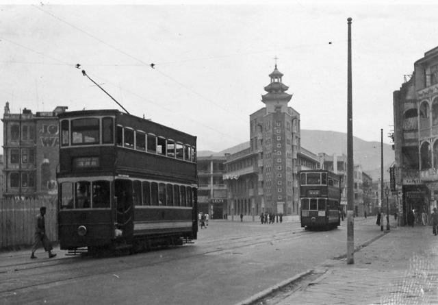
I first thought the photo was taken after the war, so the date would be late 1945 to the end of 1946. The discussion showed that on the photo trams at the junction of Hennessy and Johnston Road with Arsenal Street can be seen, with the Chinese Methodist Church in the center. Here the trams come from Arsenal Street and not - as today - from Hennessy Road.
So the date would not be 1945/46, but earlier. I found the same image on flickr by HT (eternal1966e). It is dated to 1936. This fits perfectly into the realignment dates for that area (1938-1939). I changed the date of the image accordingly.
Comments
Pre-war or Post-war
I guess it might be pre-war as the gates didn't applied on trams after war. Trams passed along Arsenal Street before Praya East Reclamation commenced. I am attaching an old map with 'T' stands for the left side tram and 'M' stands for the Methodist Church. Also another circa 1990 view showing the tramlines 'turn-in' as seen today.
Joseph
Is it possible that the 1946
Is it possible that the 1946 photo is flipped? It doesn't look quite right.
breskvar
Pre-war?
Here's a photo of this area taken near the end of the war, showing the bomb-damage to Wanchai. It also shows that Hennessy Road runs on to Queen's Road, so the trams no longer had to make a turn into Arsenal Street:
Does anyone know when the tram line stopped using Arsenal Street?
Regards, David
Flipped?
I've enlarged the photo, so we can see some of the words more clearly. They show the photo is the right way around.
I think it looks odd because we're not used to seeing the trams approach the church from this angle.
Regards, David
Arsenal street and trams
Hi David
This is an enlarged section of a map dating from 1924, but with revisions up to 1945. Unfortunately it doesn't show the tram line but it does confirm that the western end of Hennessy Road still had a sharp kink in it. Certainly, in 1957 there was a large area of derelict land to the south of the China Fleet Club and the Missions to Seamen buildings, as on this photograph in my 1958 folder. Perhaps it was in very late 1945 or even 1946 that the kink was removed and the tram line straightened out.
David - did I send you a DVD a year or so ago containing several old maps? If not let me know and I'll make a copy for you.
Regards, Andrew
Sensible
Hi David,
Thank you for bringing into my mind some perspective about this scene. I have not been able to picture this properly in my mind before. Now that you've clarified the photo being the right way round, I can see where the photographer must have stood.
breskvar
Arsenal Street re-alignment
Hi Andrew,
Thanks for posting the map. I don't think I've received the disk of maps before, but it sounds very useful. Please send me a copy if convenient.
I think I've pinned down the date of the realignment to the end of the 1930s, later than I expected. In the 1938 PWD report, it mentions:
9. Works under construction were :— [...] re-construction of junction of Hennessy Road, Arsenal Street and Queen's Road East; [...]
The 1939 PWD report shows work was still underway:
172. Praya East Reclamation Scheme:—Improvements were put in hand comprising the re-alignment of Queen’s Road East and Hennessy Road at Arsenal Street Junction.
The reports for 1940/41 aren't online, but judging by the c.1945 photo above, the work was finished before the fighting started in 1941.
That also raises the question of why this photo appears in a collection titled "India, Burma & Hong Kong, 1944 - 1946: Views and life in S.E Asia as seen through the lens of No5Commando". I bought a photo album that had belonged to a serviceman, and had a couple of pages titled "Hong Kong 1945". The photos were photo postcards he'd bought in Hong Kong in 1945, but were printed from photos taken in the mid-1930s. I guess something similar has happened in this case.
Regards, David
Hi David
Hi David
Between you all, a good solution has been reached. I'm slightly surprised that what would have been a fairly easy amendment to the map that I posted wasn't made before it was printed in 1945/6.
I'll burn a DVD for you and post it in a day or two.
Regards
Andrew
Re: Photo
I also tend to think the photo was taken before WWII. In 1945/1946 the area in the vicinity would have looked like this
Looking at Moddsey's photo,
Looking at Moddsey's photo, does it mean that we can conclusively say the photo was taken before 1941 because there was no pillbox around?
breskvar
Hi All
Hi All
In response to Moddsey and Breskvar, I'm a bit worried that there is a danger that we might be confusing two junctions. The methodist chuch/hall building was, and still is, in the triangle of land where Hennessy Road and Johnston Road meet and that's featured on David's(?) first photograph. The more recent one from Moddsey showing the pill box is of the junction a bit further to the west where Hennessy Road meets Queen's Road East - where the Air Raid Shelter doors are set into the hillside. This junction is the sixth one, 1950s Hennessy Rd / Queens Road east Junction in my 1957-8 folder. What a pity I didn't stand a bit further back. Then, the pill box (if it still existed in 1958) would have been visible! The balconies on the Hennessy Road side of the building match those on Moddsey's photograph, but all the advertisements on mine show that they must have been added after his photograph was taken. I hope this clarifies things a bit and doesn't generate more confusion!
Best wishes, Andrew
Thank you
Many thanks Andrew. Clearly, I haven't yet got my head around the area (spatially) in a proper manner. Thank you for clarifying the confusion.
breskvar
Hi Breskvar
Hi Breskvar
Let's just hope that Moddsey agrees with my reasoning. My Memories of locations on Victoria from 57 years ago are pretty sound - no doubt helped by my visits in the 1980s before things changed too much. Thinking about that pill box, I have a gut feeling that it had,already gone by 1958 - but I could easily be wrong!
Andrew
Re: Photo
Yes, agreed the photo in my reply is west of the church. Just trying to show the general area opposite the church in 1945/46. Not sure but I think the fenced area may have been the area that had Japanese curio shops or part of the military area that faced Arsenal Street
Date of image
Hi everybody,
The image I posted is from the website "Commando Veterans Association" and related to "India, Burma & Hong Kong, 1944 - 1946". Some of you already suspected that this image might not be taken by Ted Tharme himself but being an older one bought by him.
Now I'm pretty sure that you are right! I found the same image on flickr by HT (eternal1966e). It is dated to 1936. This fits perfectly into the realignment dates for that area (1938-1939). I will change the date of the image accordingly (soon).
Possibly other images of that Ted Tharme series are also incorrect regarding their date.
Regards, Klaus
P.S. More HK Tram photos are here.
trams
Hi Klaus
I really enjoyed seeing the photographs of the trams - especially three, maybe four, that were taken in the vicinity of the old cricket ground. One of them was taken looking towards where I stood to take this photograph of a pal at the Cheero Club, located on the old Murray barracks parade ground. Another showing the two trams was taken from near where my pal stood on this photograph. All very nostalgic!
Andrew
Re-Realignment of Tram Tracks at Johnston and Hennessy Roads
China Mail 2 February 1939 (excerpt from HK Tramways Annual Report)
Just about by the close of the year (1938), the new alignment at Arsenal Street was completed and a new double track was laid in the centre of the new 100 ft road between Queen's Road East and the junction of Hennessy Road and Johnston Road. The length of the new track is 310 yards. The elimination of the Arsenal Street curves will not only effect a saving in wear and tear but has greatly improved the general layout of the tramway at that important junction.
China Mail 22 December 1938
Captioned Straight and Narrow. The new tram track across Arsenal Street has been completed. However the new road (Hennessy) will take 3 to 4 weeks to complete.
1935 Hennessy Road
Hennessy Road between Arsenal and Fenwick Streets.The fenced-off area diagonally opposite the Chinese Methodist Church.
Tram Tracks Realignment
The realignment of the western end of Hennessy Road and the tram tracks were completed in 1938-1939. The business card below shows the former tram track alignment into Arsenal Street.